This is most of the info of Halsall from other sites. To search for something specifically, use the search box at the top
Click on image for a bigger photograph.
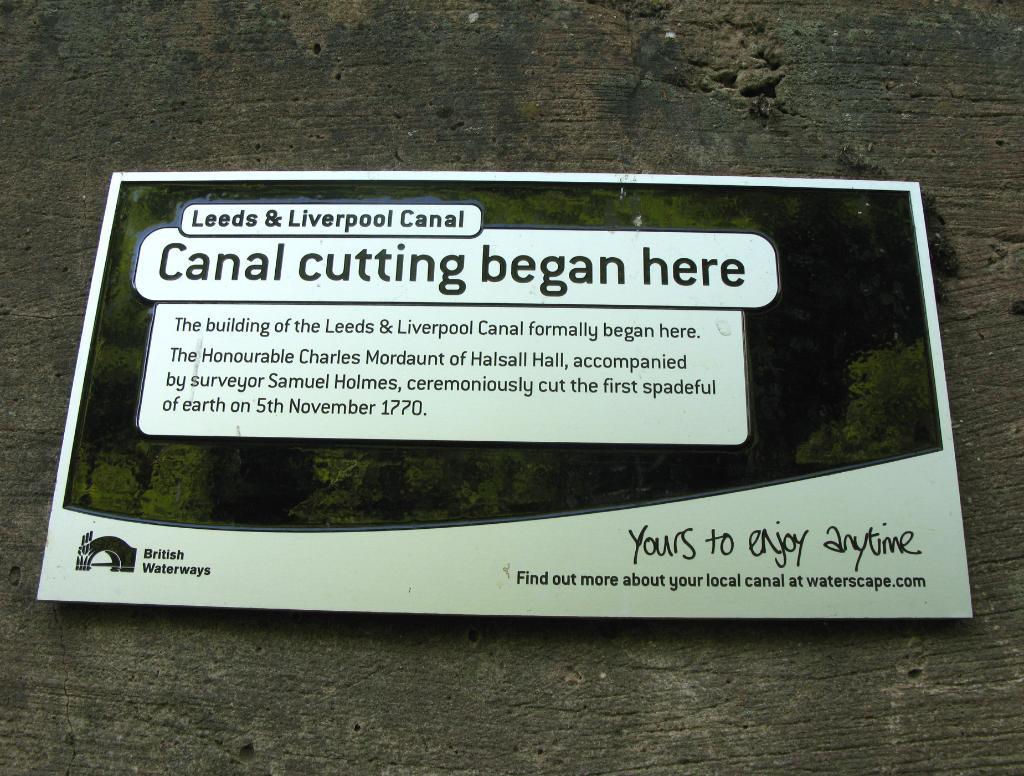
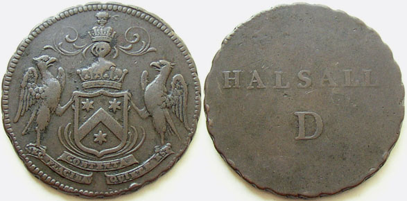
Mordaunt's Halsall (Lancashire) copper Conder penny token undated, probably 1792. Obverse: Coat of arms supported by two falcons above banner reading: “CONTENTA NEC PLACIDA QUIETE EST”. Reverse: Legend on two lines: “HALSALL D”. Heavily patterned edge. Penny, arms of the Earls of Peterborough, rev. value, edge engrailed, 16.16g/6h (DH 1). Small die flaw in reverse field. These were issued by Colonel Charles Lewis Mordaunt to pay his workers at Halsall Cotton Mill. Col Charles Lewis Mordaunt (c.1729-1808), a former Guards officer appointed JP in March 1763, came into possession of the Mohun estate at Halsall in the late 1760s. A decade later he had built a water-powered spinning/cotton mill there and by 1782 was employing 160 women and children. As early as December 1783 John Moon, Mordaunt’s superintendant, was in touch with Boulton & Watt, enquiring about having tokens made; it would seem that they were issued shortly after this time and, if this were the case, they would pre-date the pioneering Anglesey series. A document on the state of the copper coinage in circulation in Liverpool in 1791 infers that Mordaunt’s pennies were, by then, not in circulation (cf. Chaloner, SCMB 1972, pp.402-3). Famously, Morduant dug the first sod of the Leeds-Liverpool canal in Halsall on 5 November, 1770.

Click on image for a bigger photograph. From: www.towpathtreks.co.uk
This brick built/covered pill box is near Halsall Cutting close to Harkers Bridge #23. It is hard to see in summer as there is a tree growing in front of it. It's roof is covered in vegetation too.

Click on image for a bigger photograph.
Halsall, Ormskirk, Lancashire

I was born in Ormskirk, Lancashire. I lived and went to school in Halsall and then Merchant Taylors' and was a choir boy under the reign of Canon Bullough. I had a very enjoyable childhood in Halsall where I lived for 19 years. My mum lived there for a further 15 years
Here is the fascinating history of Halsall according to the Internet
Click here to see the Halsall conservation area
Click here to see The Office of National Statistics data for Halsall
Click here to see census, birth, marriage and burial data for Halsall
Click here for the top surnames in Halsall in 1881
If you would like to search for anything on this page, click on Edit at the top, and then Find and type what you are looking for in the box in the bottom left of the screen
From: http://uk-genealogy.org.uk/england/Lancashire/towns/Halsall.html
Halsall, a village, a township, and a parish in Lancashire. The village stands near the Leeds and Liverpool Canal, is a scattered place, and has a station, called Barton and Halsall, on the Cheshire Lines Committee's railway, and a post and telegraph office under Ormskirk; money order office, Orms-kirk. The township includes also the hamlets of Barton and Haskeyne. Acreage, 6995; population, 1264. The parish contains likewise the townships of Down Holland, Lydiate, Moiling, and Maghull. Acreage, 16, 679; population of the civil parish, 5451; of the ecclesiastical, 1568. A considerable area of marsh land has been reclaimed and laid out as farms. The manor belongs to the Castega family. Good building stone is found. The living is a rectory in the diocese of Liverpool; gross value, £3500 with residence. The church is a fine example of the Decorated order, consists of nave, three aisles, and chancel, with tower and spire, contains a piscina, effigies of a priest and a knight, and several mural monuments, and was thoroughly restored in 1886. There is an endowed school for boys, founded in 1593, and other charities.
From: http://www.genuki.org.uk/big/eng/LAN/Halsall/
and
http://www.visionofbritain.org.uk/place/place_page.jsp?p_id=10301&st=HALSALL
In 1870-72, John Marius Wilson's Imperial Gazetteer of England and Wales described Halsall like this:
HALSALL, a village, a township, a parish, and a subdistrict, in Ormskirk district, Lancashire. The village stands near the Leeds and Liverpool canal, 3 miles NW of Ormskirk r. station; is a scattered place; and has a post office under Ormskirk. The township includes also the hamlets of Barton and Haskeyne. Acres, 6, 996. Real property, £10,661. Pop., 1,204. Houses, 196. The parish contains likewise the townships of DownHolland and Melling, and the chapelries of Maghull and Lydiate. Acres, 1,658. Real property, £36,268. Pop. in 1851, 1, 510; in 1861, 1, 672. Houses, 803. The property is much subdivided. The manor belongs to Lady Scarisbrick. Good building stone is found; and a kind of moss exists which has been used for candles. The living is a rectory in the diocese of Chester. Value, £3,500.* Patron, H. H. Blundell, Esq. The church consists of nave, three aisles, and chancel, with tower and spire; contains a piscina, an effigies of a priest, and several mural monuments; and is in good condition. The p. curacies of Maghull, Melling, and Lydiate, are separate benefices. There are a national school for girls, an endowed school for boys, with £26, and other charities with £200. The sub-district comprises Halsall and Down Holland Townships. Acres, 10,470. Pop., 952. Houses, 329.
From: http://www.genuki.org.uk/big/eng/LAN/Halsall/StCuthbert.shtml
Church History: St Cuthbert's was founded in Norman times. The first Rector of Halsall was Robert (no second name known), c.1190. There was originally a Norman Church founded on the site (no documents are known with the date of foundation). The early English church was started around 1290. The church has undergone numerous alterations over the centuries. Scheme of alterations:
From: http://www.allertonoak.com/merseySights/OutlyingAreasMH.html
St. Cuthbert's Church, Halsall
Halsall was recorded in the Domesday Book, when it was one of the principal manors in the district. The village used to sit at the edge of a great moss that spread out to the west and became flooded in winter. Like much of the neighbouring area, the land has now been drained and is fertile crop growing territory. The church of St. Cuthbert dates from about 1320, probably replacing an earlier church, and stands on slightly higher ground, along with most of the older habitations. The 126 ft (38 m) tower and spire were added in about 1400, though the present spire is a more recent replacement. In mediaeval times, it appears that the area was leased to the Lord of Warrington, who extraordinarily enough paid 1 lb of cumin for the annual rent. I wonder if they had a curry house back then. The Leeds and Liverpool Canal passes behind the village and, indeed, the first excavations took place here in 1770.
Halsall in Lewis's Topographical Dictionary of England (1848)
It is situated near the coast, and intersected by the Leeds and Liverpool canal, which passes through each of its townships; the views of the sea are good, and the air salubrious. There are some quarries of freestone; and in Halsall moss, which is rather extensive, is found a bituminous turf, which burns like a candle. The parochial church is handsome, partly in the decorated and partly in the later English style, with a lofty spire, and forms a conspicuous object in the scenery.
Halsall in the Victoria History of the County of Lancaster (1907)
This township had formerly a great moss on the west, covering about half the surface, and constituting an effectual boundary. Down to recent times there were also three large meres - Black Otter, White Otter, and Gettern. The fenland has now been reclaimed and converted into fertile fields under a mixed cultivation - corn, root crops, fodder, and hay. There is some pasture land, and occasional osier beds fill up odd corners. The soil is loamy, with clay beneath. The low-lying ground is apt to become flooded after wet weather or in winter-time, and deep ditches are necessary to carry away superfluous water. In summer these ditches are filled with a luxuriant fenland flora, which thus finds shelter in an exposed country. The scanty trees show by their inclination the prevalence of winds from the west laden with salt. The ground rises gently to the east; until on the boundary 95 ft. is reached. [...]
The Liverpool, Southport, and Preston Junction Railway, now taken over by the Lancashire and Yorkshire Company, formed a branch through the township with a station called Halsall, half a mile west of the church, and another at Shirdley Hill. The scattered houses of the village stand on the higher ground near the church. To the south-east is the hamlet of Bangors Green; Four Lane Ends is to the north-east. From near the church an extensive and comprehensive view of the surrounding county is obtained. The northern arm of the Downholland Brook rises in and drains part of the district, running eventually into the River Alt, which is the natural receptacle for all the streams and ditches hereabouts. The Leeds and Liverpool Canal crosses the southeastern portion of the township, with the usual accompaniment of sett-laid roads and untidy wharfs. [...] The hall is to the south-west of the church; between them was a water-mill, taken down about 1880. North-east of the church are portions of the old rectory house, consisting of a wall 55 ft. long, with three doorways and three two-light windows, several traces of cross walls, and a turret at the north-west. Part is of fourteenth-century date.
From: http://www.numsoc.net/halsall.html
The Halsall Penny and Colonel Mordaunt’s Mill
How Happenings In A Lancashire Village Changed The World
Whenever is told the story of the Industrial Revolution, the Lancashire village of Halsall and the name of Colonel Mordaunt seldom feature largely, and yet in a succession of three individually small events they influenced the course of affairs which changed the basis of human society and brought about the world we live in today. These are great claims, but can they be justified?
Our story really begins with Colonel Mordaunt. Charles Lewis Mordaunt was born in 1730 to father Charles, a nephew of the Earl of Peterborough, and mother Anne, formerly Anne Howe. As did many scions of the nobility, Charles Mordaunt entered upon a military career, serving in the Guards, and travelling out to India where he developed a taste for exotic pastimes, including cockfighting.
Promotion in the army came quickly, as it could to those of adequate means in the days of purchased commissions and by 1765, when he retired from the service, Mordaunt had reached the rank of Colonel. His retirement may have been prompted by his acquisition, in the early 1760s, of the Mohun estate at Halsall by marriage to the widow of Lord Mohun, and it was at Halsall Hall that Mordaunt took up his residence. The Mordaunt coat of arms was placed over the door leading to the courtyard at the rear of the Hall, and a spouthead still exists bearing the date 1769 together with the crest and initials of Col. Mordaunt.
Change was in the air: the Colonel bored for coal in the Rectory garden - a process assisted by his brother Henry Mordaunt being Rector - and tapped a chalybeate spring. Rector Mordaunt rebuked his brother for his wild ways - ‘he enlivened Ormskirk with public sword practice’ - and the Colonel responded by making a bonfire out of green stuff and smoking brother and congregation out of the the Church.
But for other reasons, Halsall, still a sleepy backwater, would soon become famous.
The First Event
One of the major constraints on economic development in the eighteenth century was the appalling state of transportation. The roads alternated between mud baths and dust bowls, depending on the season, while navigable rivers were few and far between. Relatively small scale works, such as the Douglas Navigation between Wigan and the Ribble Estuary, had improved matters to some extent, but in 1767 two groups of far-sighted businessmen set up committees, one in Liverpool and one in Leeds, to investigate the construction of a canal to link the growing industrial areas with the coal fields and the major ports of the North East and North West of England. The outcome of their planning was the Leeds and Liverpool Canal Act of 1770, which authorised the construction of the first major canal in Great Britain. The route of this canal passed immediately adjacent to Halsall, and the very first sod turned, in the construction of this industrial miracle, was turned on 5th November 1770 by Col. Mordaunt himself.
In 2006 a stone statue of the 'Halsall Navvy' by sculptor Thompson Dagnall was unveiled adjacent to the canal in Halsall to commemorate this event.
The Second Event
In his story so far, Col. Mordaunt seems to have followed the typical career of a gentleman of means, but at some point, now uncertain, the Colonel seems to have taken up the trade of cotton spinning. Equally uncertain is whether there was already a mill at Halsall, or whether Col Mordaunt started from scratch, but start he certainly did. The first positive evidence we have is found in a letter which he wrote to the Secretary At War on 7th October 1779, at the time of the cotton riots in Lancashire, giving warning of a riotous mob forming at Halsall. A sergeant and fourteen soldiers were sent from Liverpool to maintain order, and presumably protect Halsall Mill.
Unlike many of his class, it seems as though Col. Mordaunt took more than a passing interest in the operation of his enterprise. A letter to the Society of Arts, written in 1780, refers to some development of the water wheel powering his mill:
'Having erected a considerable work by his majesty's Patent and being deficient in Water during the Summer Months, I thought of reworking the Water by the means enclosed, if it answers in operation, it will be an Acquisition of great consequence to Mechanics.'
It appears as though Col. Mordaunt believed he had achieved some kind of perpetual motion machine, and the paper was 'laid aside till further Notice.'
The reference to 'his majesty's Patent' concerned a patent which had been granted to Col. Mordaunt in 1778 for 'preparing cotton, sheep's wool, and flax; materials and necessary articles for manufacturing cotton and linen cloth.' Richard Arkwright's patents of 1769 and 1775 were still in force, and it seemed likely that some part of Col. Mordaunt's 'considerable work' might infringe Arkwright's rights. He certainly thought so, and as part of a programme of intended retribution against infringers of his patents, Arkwright launched a series of law suits in 1781 against ten mill owners whom he considered to be the principal culprits.
The Lancashire Ten decided that an attack on one was an attack on all, and agreed to mount a common defence. One of the Ten was Col. Mordaunt who, according to a leading Treasury Counsel of the time was 'a gentleman of family but not much fortune, who was thought from the lightness of his purse, the fittest to be put in the front.' Fortunately for Mordaunt, Arkwright lost the case, but because of the rather primitive nature of patent law at the time, did not lose his patents. This had to wait for a further trial in 1785 when the overthrow of the patent restrictions resulted in a massive expansion of mechanisation in the cotton industry. Arkwright's consolation was a knighthood, awarded in 1786.
The Third Event
By 1782, Col. Mordaunt could write to the Duke of Rutland:
'I am obliged for your enquiries after my health and our little work at Halsall. We have 600 spindles complete with their appendages - our powers calculated to 1,300 - an employment for about 160 poor children and women.'
By this time, the mill is recorded as being powered by an eighteen foot diameter overshot water wheel, fed by a stream. To anyone who examines the topography of Halsall today, it is quite difficult to understand quite how such a fall of water could ever have been achieved.
The relative scarcity of water, and the lack of height to provide a fall to drive the wheel, undoubtedly explain why, in 1782, Col. Mordaunt, through his Mill Superintendent John Moon, opened discussions with Boulton and Watt, of Soho, Birmingham, for the possible supply of a 'patent Fire Engine' which would be used either to pump water to operate the water wheel, or to operate the mill directly.
Whatever the irregularity of the water supply, it was nothing to the irregularity of the coinage. Effectively, no silver had been coined since 1758, and the Royal Mint had ceased production of copper in 1775. Increasing industrialisation meant an increasing burden for employers who required cash to pay their employees, and who were ever more unable to find sufficient quantities. There was no real shortage of money; there were local and Bank of England bank notes, and an adequate supply of gold coins. The real need was for small denominations which bore some relationship to the costs of living for mill workers. Worn-out discs of metal, forgeries and 'evasions' all became acceptable in the absence of anything better.
We will never know why, or when, the linkage occurred in Col. Mordaunt's mind, between his two perennial problems, water and cash, but there is no doubt that on 2nd December 1783, Superintendent John Moon wrote what has become one of the most significant letters in eighteenth century numismatics. It was addressed to Boulton and Watt:
Gentlemn.
We are frequently at a loss for Good Copper to pay the Hands employed under the Honrble Colonl Mordaunt at his Cotton Works now in a very flourishing state; His Honor order’d me this Day to write to you for a Die to Stamp Copper; The value of one, must be one Penny the other Two Pence; Or the weight of Four good Half Pence for the support in payment of the hands at his Works The Die with the Earl of Petersbourgh’s Coat of Arms on one side; And the word Halsall across the back. As you are coversant in Novels; I wish you to make (or procure made) the above mentioned Die for His Hons use; In this youl merrit the esteem of His Honr
For whom, I am yr most Obt Servt.
John Moon
Certainly the pennies exist, today, though there has never been any indication that two pences were ever produced.
Certainly the designs of the coins are precisely as set out in Mr Moon's letter. But in 1783, Matthew Boulton did not have a mint, as such, and whether he took the matter up, or whether he let it go to another manufacturer, we do not know. Boulton might have made the coins - he had been producing coin weights at Soho since 1775, and there is not that much difference between a coin and a coin weight - or possibly he made the dies and contracted the striking to someone else. The record is silent. And frustrating.
But whatever the source of the Halsall Penny, it seems likely that it pre-dates the enormous issue of penny tokens from the Parys Mine Company, in Anglesey, which started in 1787. The Halsall Penny is almost certainly the first of the flood of copper tokens which mark the great expansion of industry in the last decade or so of the eighteenth century.
Speculation, questions, but not many answers
But the Halsall Penny was not, of itself, a flood. Writing in 1908, in his 'Notes on Southport and District,' the Rev W T Bulpit described the Halsall tokens as 'now very valuable' but while the coins are not rare, neither do they appear in the bottom of junk boxes in street markets, as do the tokens of the Parys Mines and John Wilkinson.
Where was Col. Mordaunt's Mill? There should be an easy answer to a simple question such as this, but there isn't. The few local records which mention the mill seem to assume that everyone knew where it was! There are two possible sources of water. The photograph at left shows a watercourse running towards Halsall village, having passed underneath the Leeds and Liverpool canal. There are no signs on the surface of the ground in the village itself, and it has been suggested that the mill might have been in the basement cellars of the Hall itself. More likely is that the mill was in a separate building, in a field at the back of Halsall Hall itself, fed by the brook
When were the Halsall Pennies produced? There is no definite information; presumably some time after 2nd December 1783, and most probably before the advent of the Anglesey tokens in early 1787.
What purpose did they serve? R C Bell in his learned review of 'Commercial Coins' suggested that the Halsall tokens might have been estate passes, serving as admission tickets to the Mill and environs. The letter from Superintendent Moon surely disproves this theory. There can be little doubt that the pennies were intended to pay the workforce.
Where did they circulate? The area of their circulation is somewhat speculative, but in the Lancashire Record Office at Preston is a document headed 'State of the Copper Coins in Circulation at Liverpool, Anno 1791' which lists, in order and including the Halsall Penny, the best tokens to be found, but makes the note 'Mordaunt not in circulation.' Although disappointing, in that 'our' pennies were not in use, the document does indicate that they were well enough known in Liverpool for their absence to be something worthy of note. So it would seem reasonable to assume that they circulated generally in the area, and were not restricted to a factory 'truck' shop, as has been suggested.
Why did they go out of use? A possible reason for the decline in circulation centres on the weight of the tokens, and the reluctance of the people to accept light weight pieces. As long as Col. Mordaunt's pennies were unique, their weight of 25 pieces to the pound of copper would not matter; they were vastly better than anything else in circulation. When the Anglesey pennies arrived in 1787, their weight of 16 pieces to the pound would make them significantly more acceptable, and the Halsall pieces would meet with rejection.
The End?
There is no evidence that Col. Mordaunt repeated his experiment in coinage. Perhaps the ubiquitous tokens from Anglesey, and then slightly later, those issued by Iron Master John Wilkinson and the myriads of Liverpool Halfpennies ascribed to Thomas Clarke, made a second token unnecessary. But whatever did or did not happen later, to Colonel Charles Lewis Mordaunt belongs a significant place in the numismatic record.
The Colonel died in Ormskirk on 15th January 1808 aged seventy eight, and is possibly buried in the Parish Churchyard. The manor was sold to Thomas Eccleston Scarisbrick, of Scarisbrick, and the advowson to Jonathan Blundell, of Liverpool
Reviewing the history of the Halsall Penny today is fascinating, but is an exercise in frustration. There is just enough certain knowledge to whet the appetite, and enough knowledge missing to make much of the story speculative. But that is the nature of numismatics! But possibly, just possibly, they represent Matthew Boulton’s first tentative steps into coining.
Chris Leather
From: http://sohomint.info/tokenstory1.html
The first private tokens of the industrial revolution consisted of a modest issue of pennies from a small Lancashire village. Unfortunately little is known of these, just that they were made for Col Charles Mordaunt, who owned a mill, now vanished, in Halsall, near Southport. In the Birmingham City Archives, there is a letter from John Moon, Superintendent of the Halsall Mill, to Boulton, dated 2nd December 1783
His Honor order’d me this Day to write to you for a Die to Stamp Copper for the support in payment of the hands at his Works. The Die with the Earl of Petersbourgh’s Coat of Arms on one side; And the word HALSALL across the back As you are coversant in Novels; I wish you to make (or procure made) the above mentioned Die for His Hons use; In this youl merrit the esteem of His Honr
Were the dies made at Soho? Did Boulton strike the coins? We have no definite indication that Boulton took the job on, even though the tokens we see today closely match Mr Moon’s description. We think we know that Boulton did not have a mint until around 1789, which would suggest that the striking was done elsewhere, but we do know that he had been producing coin weights since at least 1775…. and in manufacturing terms there is little practical difference between a coin weight and a coin! But we don’t really know. As for its acceptability, a contemporary survey of tokens in circulation in Liverpool in 1791 reported that Col Mordaunt’s token was not found which, at least, suggests that it was well-enough known to have been expected.
From: http://www.numsoc.net/lancsct.html
The Eighteenth Century - I - Halsall and Lancaster By the beginning of the eighteenth century copper was well and truly established as the every day money of the poor. As the century progressed, new coppers were struck less and less often, until by 1775 production entirely ceased, just as the Industrial Revolution, and the rise of cash wages, put an increased demand on the copper coinage.
A survey by the Royal Mint in 1787 found that more than 90% of the coppers in circulation consisted of forgeries and evasions - coins which looked superficially like the real thing, but had meaningless inscriptions in order to avoid charges of forgery. In the face of governmental inertia, only one solution was possible. A second major round of vernacular token coinage began.
Precisely when is unclear. The best estimate is somewhere between the end of 1783 and around 1785. Where is quite clear. The 18th century answer to the cash shortage began at the cotton mill of Colonel Charles Mordaunt, in Halsall, near Southport.
There is a possibility that the dies for this issue were made by Matthew Boulton, but nothing is known for certain. By 1791, Colonel Mordaunt's pennies were reported as being no longer found in circulation in Liverpool. They had been supplanted by the Druid coins issued by the Parys Mine Company of Anglesey, and the Liverpool tokens of Thomas Clarke.
From: http://www.allertonoak.com/merseySights/OutlyingAreasLH.html
St. Cuthbert's Church, Halsall
Halsall was recorded in the Domesday Book, when it was one of the principal manors in the district. The village used to sit at the edge of a great moss that spread out to the west and became flooded in winter. Like much of the neighbouring area, the land has now been drained and is fertile crop growing territory. The church of St. Cuthbert dates from about 1320, probably replacing an earlier church, and stands on slightly higher ground, along with most of the older habitations. The 126 ft (38 m) tower and spire were added in about 1400, though the present spire is a more recent replacement. In mediaeval times, it appears that the area was leased to the Lord of Warrington, who extraordinarily enough paid 1 lb of cumin for the annual rent. I wonder if they had a curry house back then. The Leeds and Liverpool Canal passes behind the village and, indeed, the first excavations took place here in 1770. Halsall in Lewis's Topographical Dictionary of England (1848)
It is situated near the coast, and intersected by the Leeds and Liverpool canal, which passes through each of its townships; the views of the sea are good, and the air salubrious. There are some quarries of freestone; and in Halsall moss, which is rather extensive, is found a bituminous turf, which burns like a candle. The parochial church is handsome, partly in the decorated and partly in the later English style, with a lofty spire, and forms a conspicuous object in the scenery. Halsall in the Victoria History of the County of Lancaster (1907)
This township had formerly a great moss on the west, covering about half the surface, and constituting an effectual boundary. Down to recent times there were also three large meres - Black Otter, White Otter, and Gettern. The fenland has now been reclaimed and converted into fertile fields under a mixed cultivation - corn, root crops, fodder, and hay. There is some pasture land, and occasional osier beds fill up odd corners. The soil is loamy, with clay beneath. The low-lying ground is apt to become flooded after wet weather or in winter-time, and deep ditches are necessary to carry away superfluous water. In summer these ditches are filled with a luxuriant fenland flora, which thus finds shelter in an exposed country. The scanty trees show by their inclination the prevalence of winds from the west laden with salt. The ground rises gently to the east; until on the boundary 95 ft. is reached. [...]
The Liverpool, Southport, and Preston Junction Railway, now taken over by the Lancashire and Yorkshire Company, formed a branch through the township with a station called Halsall, half a mile west of the church, and another at Shirdley Hill. The scattered houses of the village stand on the higher ground near the church. To the south-east is the hamlet of Bangors Green; Four Lane Ends is to the north-east. From near the church an extensive and comprehensive view of the surrounding county is obtained. The northern arm of the Downholland Brook rises in and drains part of the district, running eventually into the River Alt, which is the natural receptacle for all the streams and ditches hereabouts. The Leeds and Liverpool Canal crosses the southeastern portion of the township, with the usual accompaniment of sett-laid roads and untidy wharfs. [...] The hall is to the south-west of the church; between them was a water-mill, taken down about 1880. North-east of the church are portions of the old rectory house, consisting of a wall 55 ft. long, with three doorways and three two-light windows, several traces of cross walls, and a turret at the north-west. Part is of fourteenth-century date.
From: http://www.lan-opc.org.uk/Halsall/index.html
Historically, the Parish of Halsall consisted of the villages of Halsall, Barton, Haskayne, Downholland, Lydiate and Maghull and the hamlets of Shirdley Hill and Bangor’s Green.
The parish is about 9 miles long and 4 miles wide and runs roughly north to south, with the market town of Ormskirk 3 miles to the east and the Irish Sea 5 miles to the west. Halsall Moss, an area of very fertile farmland reclaimed by drainage, occupies much of the western part.
The name Halsall comes from the Doomsday word Heleshale meaning “rising ground near the edge of the great bog or mire” but by 1212, the village was already referred to as Halsale.
The Parish Church of St Cuthbert dates from 1250 but has been rebuilt and embellished in the intervening years. It is regarded, by many, as one of the finest churches in the area.
The population and its environment were very much influenced by the advances made in transport during the Industrial Revolution. At one time the parish could boast a turnpike road, a canal and two railways.
From: http://en.wikipedia.org/wiki/Halsall
Halsall is a village and civil parish in West Lancashire, England, located close to Ormskirk on the A5147 and Leeds and Liverpool Canal. The parish has a population of 1,921 and covers an area of 28.31 square kilometres. The church and much of the village stand on a rocky ridge, in marked contrast to the low-lying flat peat mossland between the ridge and the sand of Ainsdale and Birkdale.
In Halsall there is St Cuthbert's Church, which dates from 1250 and is famed as the oldest Parish Church in England (although several reconstructions have taken place), the vicar of which is the Rev. Paul Robinson (also vicar of Lydiate). There is a junior school, St Cuthbert's Church of England Primary School with around 140 pupils from age 4 to 11. The Saracen's Head pub is a large public house on the banks of the canal. There is also a post office, a garage, a financial adviser office (in what used to be the Scarisbrick Arms public house) and a phone box. Halsall now has a pharmacy, situated by the playing fields. The central feature in the village is the war memorial located in front of the church on what is now a traffic island.
Halsall is where the first sod was ceremonially dug (on 5 November 1770, by the Hon Charles Mordaunt of Halsall Hall) for the commencement of the Leeds and Liverpool Canal, and a sculpture ("Halsall Navvy" by Thompson Dagnall) just across the bridge from the Saracen's Head pub now commemorates this. Halsall Hall still stands, but it is now divided into several houses.
Halsall built up from being a small farming settlement, and, reflecting this background, a lot of the land area of Halsall is sparsely populated with many isolated dwellings. The land area (and postal area) of Halsall extends quite a way towards Ainsdale along Carr Moss Lane, to a point where the border is closer to Ainsdale village centre than it is to Halsall.
The village has two bus stops, served by the 300 bus route, operated by Arriva, travelling from Liverpool to Southport (and the reverse) and the 315 operated by Holmeswood Coaches, running between Southport and Ormskirk. Halsall railway station on the Liverpool, Southport and Preston Junction Railway was in service between 1887 and 1938.
From: http://www.british-history.ac.uk/report.aspx?compid=41318
The parish of Halsall is about ten miles in length, and has a total area of 16,698 acres, (fn. 1) of which a considerable portion is reclaimed mossland.
Judging by the situation of the various villages and hamlets it may be asserted that in this part of West Lancashire the 25 ft. level formed the boundary in ancient times of the habitable district. All below it was moss and swamp, which here formed a broad and definite division between Halsall parish on the east and Formby and Ainsdale on the west.
The parish used to contribute to the county lay as follows:—When the hundred paid £100, it paid a total of £6 5s. 0¼d., the townships giving—Halsall, £1 8s. 1½d.; Downholland, £1 5s. 9½d.; Lydiate, £1 5s. 9½d.; Maghull, 17s. 2¼d.; Melling, £1 8s. 1½d. To the more ancient fifteenth the contributions were: Halsall, £2 4s. 1½d.; Downholland, £1 12s.; Lydiate £1 8s. 8d.; Maghull, 12s.; and Melling, £1 13s. 4d. or £7 10s. 1½d. when the hundred paid £106 9s. 6d. (fn. 2)
Before the Conquest the whole of the parish, with the exception of Maghull, was in the privileged district of three hides. Soon after 1100 the barony of Warrington included the northern portion of the parish, Halsall, Barton, and Lydiate; while Maghull was part of the Widnes fee, and Downholland and Melling were held in thegnage.
The history of the parish is uneventful. During the religious changes of the Tudor period, Halsall is said to have been the last parish to adopt the new services. This, of course, cannot be proved; but the immediate reduction of the staff of clergy, the partial or total closing of the chapels at Maghull and Melling, and the careful dismantling of that at Lydiate, are tokens of the feeling the changes inspired.
The freeholders in 1600 were Sir Cuthbert Halsall of Halsall, who was a justice of the peace; Lawrence Ireland of Lydiate, Lydiate of Lydiate, Richard Molyneux of Cunscough, Richard Hulme of Maghull, Richard Maghull of Maghull, Robert Pooley of Melling, Robert Bootle of Melling, Gilbert Halsall of Barton, Henry Heskin of Downholland. (fn. 3) In the subsidy list of 1628, the following landowners were recorded:—At Halsall, Sir Charles Gerard and Mr. Cole; Downholland, Edward Haskayne and John Moore; Lydiate, Edward Ireland and Thomas Lydiate; Maghull, Richard Maghull; Melling, Robert Molyneux, Robert Bootle, Lawrence Hulme, the heir of William Martin, Anne Stopford, widow, and the heirs of John Seacome. (fn. 4) George Marshall of Halsall, Edward Ireland, and Robert Molyneux paid £10 each in 1631 on refusing knighthood. (fn. 5)
The recusant and non-communicant roll of 1641 names five distinct households in Halsall; large numbers in Downholland and Lydiate; several at Maghull, and at Melling. (fn. 6)
During the Civil War there is little to show how the people of the district were divided. The principal manorial lord, Sir Charles Gerard of Halsall, was a Protestant but a strong Royalist; he probably did not live much in the place. His son and successor was an exile. Ireland of Lydiate was a minor; Maghull was in the hands of Lord Molyneux, a Royalist; and Robert Molyneux of Melling was on the same side. The Gerard manors were of course sequestered by the Parliament, and in 1653 orders were given to settle a portion of them, of the value of £600 a year, upon the widow and children of Richard Deane, later a general of the fleet. (fn. 7) Radcliffe Gerard, brother of the late Sir Charles, described as 'of Barton,' petitioned for delay in paying his composition because his annuity had not been paid for twelve years past. (fn. 8) John Wignall, of Halsall, was allowed to compound in 1652. (fn. 9)
The troubles of the Irelands are narrated under Lydiate; the estate of Edward Gore there was sequestered and part sold. (fn. 10) Confiscations at Maghull and Melling are related in the account of these townships; in the former place also Richard Mercer, a tailor, had had his estate seized for his 'pretended delinquency,' but it had never been sequestered and he obtained it back. (fn. 11)
The hearth tax of 1666 shows that very few houses in the parish had three hearths. In Downholland the Haskaynes' house had seven hearths and the hall five. In Lydiate the hall had ten; in Maghull James Smith's had nine and Richard Maghull's six; in Melling Robert Molyneux's house had ten hearths, William Martin's six, Thomas Bootle's five, and John Tatlock's, in Cunscough, eight. (fn. 12)
The connexion of Anderton of Lydiate with the Jacobite rising of 1715 seems to be isolated; the squires and people generally took no share in this or the subsequent rising of 1745.
The land tax returns of 1794 show that, except in Lydiate, the land was in the possession of a large number of freeholders.
The making of the Leeds and Liverpool Canal at the end of the eighteenth century did something to open up the district, which has, however, remained almost wholly agricultural.
The geological formation consists entirely of the new red sandstone, or triassic, series. Taking the various beds in rotation from the lowest upwards, the pebble beds of the bunter series occur to the eastward of the canal in Melling, and to the south of a line drawn from Maghull manor-house to the nearest point on the boundary of Simonswood. To the east of a line drawn southward from Halsall village to pass a quarter of a mile or so to the eastward of the villages of Lydiate and Maghull, following the line of a fault, the upper mottled sandstones of the same series occur, whilst to the west of the same line the formation consists of the lower keuper sandstones. To the north-west of a line drawn from Barton and Halsall station to Scarisbrick bridge, spanning the Leeds and Liverpool Canal, the keuper marls occur, whilst the waterstones, which elsewhere intervene between these two members of the keuper series, are entirely wanting.
There are stone quarries at Melling and Maghull, producing good grindstones. About 1840 some of the inhabitants were employed in hand - loom weaving. (fn. 13) The agricultural land is occupied as follows: Arable, 13,337 acres; permanent grass, 1,515; woods and plantations, 10.
CHURCHThe church of St. Cuthbert consists of a chancel with north vestry and organ chamber, nave with north and south aisles and south porch, west tower and spire, and to the south of the tower a late sixteenth-century building, formerly a grammar school. It stands finely on rising ground on the edge of the broad stretch of level land which once was Halsall Moss, and is, as it must have been designed to be, a conspicuous landmark for miles round. Two roads join at the west end of the churchyard, from which point a raised causeway runs across a depression in the ground in which is a little stream flowing northward, and joins the outcrop of sandstone rock, facing the church, on which the hall and part of the village stand.
No part of the church as it exists to-day is older than the fourteenth century, and its architectural history seems to be as follows. The nave with north and south aisles and south porch were begun about 1320, doubtless replacing the nave of an older building, whose eastern portions were left standing till 1345–50, when they were destroyed and the present fine and stately chancel built. The work seems to have gone on continuously, but there were several alterations of the first design, which will be noticed in their place. When the new chancel was complete— it was no doubt built round the old chancel after the usual mediaeval fashion, beginning at the east—it is quite clear that the intention of the builders was to go on and re-model the nave, if not to rebuild it, although it was barely thirty years old at the time. But the work came to a sudden stop when the east wall of the south aisle was being built, and nothing more was done to the fabric for some fifty or sixty years, when the west tower and spire were added, and the church assumed substantially its present appearance. About 1520 a large three-light rood window was inserted high up in the south wall of the nave, and in 1593 Edward Halsall's grammar school was built at the west end of the south aisle. The north and south aisles were nearly rebuilt in 1751 and 1824, and in 1886 the north wall of the north aisle and vestry was rebuilt throughout its length, as was the greater part of the south aisle wall, with the south porch and doorway, though both this doorway and the outer arch of the porch have been reconstructed with the old stones as far as they would serve.
Remains of mediaeval arrangements are plentiful. In the chancel are triple sedilia and a piscina, a large piscina and a locker in the vestry, and there are piscinae at the eastern ends of both nave aisles. Traces of the roodloft are to be seen, and the roodstair remains perfect, but the nave altars below the loft have left no trace. The patron saint's canopied niche exists on the north of the altar, and in the north wall of the chancel is a fine sepulchral recess which was doubtless made use of in Holy Week for the purposes of the Easter Sepulchre. A wood screen on a low stone wall stood in the chancel arch, and against it the stalls were returned. Some of these stalls, of the fifteenth century, still remain, but the return stalls, for which evidence was found some years ago, have disappeared. A turret for the sanctus bell stands on the east gable of the nave.
The architectural details of the chancel are exceedingly good, and in common with the rest of the church it is faced with wrought stone both inside and out. Its internal dimensions are 47 ft. long by 20 ft. 6 in. wide, and it is 46 ft. high to the ridge of the roof. It is divided into three bays, having three-light windows in each bay on the south side, and a five-light east window. There are no windows in the north wall. The stone used is a sandstone of local origin, but of a quality very superior to the ordinary. The jambs and heads of the windows are elaborately moulded, internally with the characteristic roll and fillet, and hollow quarter-round; while externally the orders are square, each face being countersunk, the effect being to leave a raised fillet at the salient and re-entering angles. This detail also occurs on the east window of the south aisle. The tracery of the east window is mainly original, and that of the south windows a modern copy of the former work; it is very late in the style, and shows a distinct tendency to the characteristic upright light of the succeeding style. Above the head of the east window, inside, is a hand carved in low relief, somewhat difficult to see from below. It is said by those who have seen it at close range to be an insertion.
The sedilia, in common with nearly all the masonry details of the chancel, are original. They are triple, with cinquefoil arches and moulded labels which mitre with the string running round the chancel walls. The three seats are on the same level, and the piscina forms a part of the composition, being under an arch similar to the other three, and adjoining them to the east. Its bowl is elaborate, with a cusped sinking of some depth, but the drain is not visible, though the bowl seems to be part of the original masonry. It projects from the wall, and is carved on the underside with foliage and a small mitred figure. The niche north of the altar, which probably held St. Cuthbert's image as patron saint, has a fine crocketed canopy, with flanking pinnacles and a central spirelet and finial. The corbel to carry the figure projects as three sides of an octagon, and is carved below with oak foliage and acorns. The image itself was bonded into the back of the recess at half height, and the head dowelled to the wall. On either side of the shafts of the pinnacles which flank the niche are two pin-holes, probably for the fastenings of iron rods.
The first ten feet of the north wall, from the east, are blank, but about opposite to the sedilia is a recess 6 ft. 6 in. wide, and 14 in. deep, under a beautiful feather-cusped arch set in a crocketed gable and flanked by tall crocketed pinnacles; the pinnacles and gable finish at the same level, about 17 ft. from the floor, with heavy and deeply-cut finials of foliage, whose flattened tops seem designed to serve as brackets for images. It is to be noted that the arch is not constructive, but all joints are horizontal and part of the walling. In the recess is a plain panelled altar tomb, on which lies an ecclesiastical effigy of alabaster, wearing a fur almuce with long pendants over an alb and cassock; the head rests on a cushion, on either side of which are small winged figures, and at the feet is a dog. The effigy is of much later date than the recess, and both effigy and recess have been injured by a process of adaptation, the back of the recess being hollowed out, and the head and feet of the effigy cut back to get them to fit the space. The effigy is not later than 1520. A tomb in this position in the north wall of the chancel was often used as the place of setting up the Easter Sepulchre, and adjoining the recess to the west is a curious masonry projection, splayed off at a height of 2 ft., and dying into the wall face at 3 ft. 9 in. from the floor. It is 4 ft. 8 in. long, with a maximum projection of 12 in. There are no traces of fastenings or dowel-holes on it (in which case it might have formed a backing for the wooden framework of the sepulchre), and its purpose is hard to understand. It is of the same date as the recess, for the stooling of the western flanking pinnacle is worked on one stone of its sloping top, and the masonry joints range with the surrounding walling. Close to it on the west is the vestry doorway, of three orders with continuous mouldings and a hood mould formed by carrying the chancel string round the arch, an admirable piece of detail, retaining its original panelled door, with reticulated tracery in the head, and lock and handle of the same date. To the west of this doorway is a modern arch for the organ. The chancel arch is of three orders with engaged shafts, moulded capitals and bases, and a well-moulded arch with labels. It is 26 ft. high to the crown, and 15 ft. 8 in. to the springing. The central shaft shows the almost obliterated traces of the coping of a dwarf stone wall 10 in. thick, and about 3 ft. high, which served as a base to a wood screen across the arch; a 3 in. fillet on the central shaft has been cut away for the fitting of this screen.
Parts of the stalls are ancient, good and deeply-cut work of the end of the fifteenth century. They were re-arranged at the late restoration, and there are now six ancient stalls on the south side, and one on the north. All these retain their ancient carved seats, the subjects of the carvings being (1) wrestlers backed by two 'religious'; (2) an angel with a key in each hand, and wearing a cap with a cross; (3) a bearded head; (4) a flying eagle; (5) a fox and goose; (6) an angel with a book, wearing a cap with a cross; (7) fighting dragons. Some of the old desks remain, with boldly carved fronts and standards, the finials being a good deal broken; one of them has the Stanley eagle and child, another a lion standing. East of the southern stalls is an altar tomb with panelled sides containing shields in quatrefoils, which have lost their painted heraldry, and an embattled cornice. On the tomb lie two effigies, said to be those of Sir Henry Halsall, 1523, and his wife Margaret (Stanley). Besides the tombs already noticed there are a fragment of a brass to Henry Halsall of Halsall, 1589, memorials of the Brownells, Glover Moore, and others. (fn. 14)
The vestry on the north of the chancel was probably built in the first instance for its present purpose. Its north wall has been rebuilt, but the south and east walls show some very interesting features. The south wall, which is also, of course, the north wall of the chancel, was originally designed as an outer wall, and had a plinth like that of the rest of the chancel; but when the wall had been built to the level of the top of the plinth the design was altered and the vestry built as it now is, the plinth being cut away, leaving its profile in the east wall. A large piscina was placed in the south wall, and the east wall built against the west side of the second buttress from the east, with a locker at the south end and a central window of one wide, single cinquefoiled light with a trefoil in the head. This window is somewhat clumsy, and shows signs of having been rebuilt. It does not belong to the chancel work, but its details are those of the nave, and it is probably an adaptation of the east window of the north aisle of the nave. Under the first design for the chancel this window would not have been disturbed, but when the vestry was added to the east it became useless, and was probably taken down and rebuilt in an altered form in its present place. (fn. 15) The two rows of corbels in the south wall of the vestry show the line of former plates, belonging to a roof now gone.
Externally the chancel has a fine moulded plinth of two stages and a string at the level of the window sills. The buttresses set back 3 ft. above the string with weathered and crocketed gablets, with excellent details of finials and grotesque masks, and are carried up through a simple parapet projecting on a corbel course to crocketed pinnacles, which have at their bases boldly designed gargoyles, the most noteworthy being that at the south end of the east face of the chancel, a boat containing a little figure with hands in prayer. In the east gable, above the great east window, is a single trefoiled light which lights the space over the chancel roof. The roof is of steep pitch, covered with lead; the timbers are mainly ancient, and are simple couples with arched braces under a collar. At the western angles of the chancel are square turrets finished with octagonal arcaded caps and crocketed spirelets. The southern turret contains the rood stair, which is continued upwards to give access to the nave and chancel gutters on both sides of the roof in an original and interesting manner. The northern turret contains no stair from the ground level, and appears never to have done so, being built solid at the bottom. It could not therefore give access to the northern gutters or roof-slopes; and this was provided by taking a passage from the south turret over the chancel arch in the thickness of the wall, opening into the north turret in its octagonal story, whence doors east and west led to the gutters. The passage rises at a steep pitch from both ends, and is lighted by four small square-headed loops, two towards the nave and two towards the chancel. (fn. 16) On the apex of the gable above is an octagonal sanctus bell-cote with a crocketed spirelet, which is open to the passage, and it is quite possible that the bell may have been rung from here at the elevation, as anyone standing at the loops looking towards the chancel has a clear view of the altar. Access to the west end of the chancel roof is also obtained from the highest point of the passage, and in the west wall at this point, exactly over the apex of the chancel arch, is a short iron bar, which may be connected with the fastenings of the rood.
The nave is of four bays with north and south arcades having octagonal bases, shafts, and capitals, 11 ft. 6 in. to the spring of the arches, which are of two orders with the characteristic fourteenth-century wave-moulding. There is no clearstory, and the whole work is much plainer and simpler than that of the chancel. The nave roof is 47 ft. high to the ridge, covered with stone healing, and the timbers are modern copies of the old work. At the east end of the nave the junction of the two dates of work is clearly shown in the masonry of both walls, and the plate level of the later work is considerably higher than that of the nave. On the south side the upper part of the wall has been cut away for the insertion of a three-light sixteenth-century window with square head, embattled on the outside, its object, as already mentioned, being to light the rood and rood-loft. There are many traces of the beams which carried the rood-loft, which was entered from the south turret by a still existing doorway. Access to the turret is from the south aisle, the lower part of its stone newel being treated as a shaft with moulded capital and base. About ten feet up the stair is lighted by three narrow loops at the same level, one on the south, looking out on the churchyard, one on the north-east, commanding the tomb in the north wall of the chancel, and one on the north-west, towards the nave, below the level of the rood-loft floor. From the north-east loop nothing but the tomb in the north wall can be seen, and it is evidently built for that object only. It was in all probability used for watching the Easter Sepulchre erected over the tomb. Anyone standing here could also command the entrance of the chancel from the nave and the south-east portion of the churchyard.
The south aisle of the nave has been largely rebuilt, but retains a piscina in the east end of its south wall. At the foot of the east wall a course of masonry of 3 in. projection runs southward from the angle by the turret doorway for 6 ft. 3 in., and its reason is not apparent, but it may show that the floor level here was originally higher, and it is further to be noted that this would go some way towards accounting for the curious fact that the base of the south nave respond is a foot higher than that of the north. (fn. 17) The east wall with its window and angle buttresses are of the chancel date, agreeing exactly in detail with the south windows of the chancel. There is a little ancient glass, some of it of original date, in this window. It is chiefly made up of fragments collected from other places, but the two angels in the tracery seem designed for their position. Owing to the projection of the stair turret the window is thrown considerably out of centre, and the roof timbers barely clear its head. It is conceivable that a gabled roof was contemplated in the projected rebuilding, which came to a sudden stop at this point. It naturally occurs to the mind that a stoppage of work on a building of this date, circa 1350, may be a result of the Black Death of 1348–9, which has left so many traces of its severity all over the country. The south doorway and porch entrance, mentioned above as partly rebuilt with the old masonry, are alike in detail, of three orders with wave moulding. Over the outer entrance is a modern niche with a figure of St. Cuthbert.
In the north aisle nothing ancient remains but the west wall and window of two lights with fourteenthcentury tracery and jambs and head with wave moulding. A little old glass is set in the window, a piece of vine-leaf border being of fourteenth-century date. The west face of this wall shows a straight joint, partly bonded across, on the line of the north arcade wall, which tells of a stage in the building of the nave when its west wall was built, but not that of the aisle. In this case it seems doubtful, as the masonry is so alike in both parts, whether the angle is much earlier than the aisle wall and represents an aisleless nave. The evidence at the corresponding western angle is destroyed.
Externally the nave has little of interest to show; the main roof has a plain parapet, much patched at various dates. On the north side is a tablet with churchwardens' names of 1700, (fn. 18) and another on the south, with the date illegible, but of much the same time. (fn. 19) The modern aisle-windows are good of their kind, square-headed, with tracery of fourteenthcentury style.
The west tower is 126 ft. high, of three stages with a stone spire, which is modern, replacing an old spire of somewhat different outline. The octagonal parapet at its base is also modern, with the four gargoyles representing the evangelistic symbols. They replace four ancient gargoyles in the shape of nondescript monsters, now to be seen set up among the ruins of the fourteenth-century building northeast of the church. The top of the parapet is 63 ft. from the ground. The tower is of the first half of the fifteenth century; whether the church had a tower before this time does not appear, but the foundations of the west wall of the nave are said to run across the tower arch, and there must have been a western wall of some sort, temporary or otherwise, before the building of the present tower, unless perhaps an older tower was preserved at the rebuilding of the nave. The design is that of the Aughton and Ormskirk towers, with square base and octagonal belfry and spire. In the belfry stage are four squareheaded two-light windows, with a quatrefoil in the head; the second stage contains the ringing floor, and forms the transition from octagon to square. The lowest stage has a two-light square-headed west window and boldly projecting corner buttresses, with raking gabled sets-off reminiscent of the chancel buttresses. In the head of the northern of the two western buttresses is a small roughly cut sinking which may have held a small figure. The tower stair is in the south-west angle, entered from within through a low angle doorway with jambs having the common fifteenth-century double ogee moulding; the stones of the jambs are marked with Roman numerals for the guidance of the masons in placing them. The tower arch of three orders is 26 ft. 4 in. high, with an engaged shaft on the inner order and continuous mouldings on the two outer, the detail being very good. Part of the walling above it may be of the nave date, and consequently a remnant of the former west wall.
The font has a circular basin panelled with quatrefoils on a circular fluted stem, which is the only ancient part, and appears to be of the early part of the fourteenth century. In the churchyard are several mediaeval grave slabs, turned out of the church during restoration; it would be a very desirable thing to bring them under cover, even if replacing in the nave floor is impossible. The octagonal panelled base of a churchyard cross is also to be seen, and the churchyard wall is of some age, probably sixteenth century, having a good deal of its old coping remaining. There is a picturesque sun-dial of 1725 with a baluster stem. Of wall paintings the church has no trace, except for a few remains of Elizabethan black-letter texts; and the piece of panelling with the Ireland arms and date 1627, at the east end of the south aisle, is the only old woodwork in the church, except part of the stalls and the chancel roof already described.
It remains to notice the gabled building running north and south, built into the angle of the tower and south aisle. It was built to contain a grammar school founded by Edward Halsall in 1593, and was originally of two stories, the main entrance being the now blocked doorway in the east wall, above which are the Halsall arms with 'E. H. 1593.' The west doorway, which is cut through the tower buttress, gave access to the stairs to the upper room, and the marks of their fitting remain in the tower plinth. Over this doorway are two panels, the upper having the Halsall arms and 'E. H. 1593,' and the lower a now illegible inscription, the words of which have fortunately been preserved:--
ISTIUS EXSTRUCTAE CUM QUADAM DOTE PERENNI EDWARDO HALSALLO LAUS TRIBUENDA SCHOLAE.
The windows, of which there are two on the west and one on the south, are of two lights with arched heads, churchwarden gothic of the poorest, inserted after the removal of the upper floor. A fireplace remains at both levels, and in the east wall is a modern doorway into the south aisle.
There are six bells, four recast in 1786, one cast in 1811, and another in 1887. The curfew bell is rung in the winter months. (fn. 20)
The church plate consists of several plain and massive pieces, all made in London, viz.: a chalice and paten, 1609; chalice and paten, 1641; flagon and paten, 1730; two small chalices, 1740. (fn. 21)
The register of baptisms begins in 1606, that of marriages and burials in 1609; but they are irregularly kept until 1662. From this time they seem to be perfect. (fn. 22)
ADVOWSONFrom the dedication of the church (fn. 23) it has been supposed that Halsall was one of the resting-places of St. Cuthbert's body during its seven years' wandering whilst the Danes were ravaging Northumbria (875– 83). The words of Simeon of Durham are wide enough to cover this: the bearers 'wandered over all the districts of the Northumbrians, with never any fixed resting-place'; but the places he names—the mouth of the Derwent, Whitherne, and Craik (Creca) —point to Cumberland and Galloway rather than to Lancashire. (fn. 24)
The patronage, like the manor, was in dispute in the early years of Edward I between Robert de Vilers and Gilbert de Halsall, (fn. 25) but the latter seems to have vindicated his right, as his descendants continued to present down to the sale of the manor to the Gerards, when the advowson passed with it. In 1719 and 1730 Peter Walter, a 'usurer' denounced by Pope, presented; (fn. 26) and about 1800 the lord of the manor sold the advowson to Jonathan Blundell, of Liverpool, whose descendant, the late Colonel H. Blundell-Hollinshead-Blundell, was patron.
The Taxatio of 1291 gives the value of Halsall as £10. (fn. 27) The Valor of Henry VIII places it at £28 10s. (fn. 28) The rectors have from time to time had numerous disputes as to tithes and other church property. Rector Henry de Lea complained that in 1313 the lord of the manor had seized his cart and horses owing to a disputed right of digging turf. (fn. 29) A later rector, about 1520, leased the tithes of the township of Halsall to his brother Thomas Halsall, the lord of the manor, for 14 marks yearly. But seven years later he had to complain that Thomas would not pay the tithe-rent, and that he had refused the rector's tenants the common of pasture on Hall green, and common of turbary, which had been customary. (fn. 30)
Bishop Gastrell in 1717 found the rectory worth £300 per annum, Lady Mohun being patron. There were two churchwardens, one chosen by the rector and serving for Halsall township, the other by the lord of the manor and serving for Downholland. (fn. 31) From this time onward the value of the rectory increased rapidly. (fn. 32) The gross value is now over £2,100.
Halsall has obviously been regarded as a 'family living' from early times, as witness the promotion of mere boys to the rectory because they were relatives of the patron.
Master Richard Halsall, a younger son of Sir Henry Halsall, was rector for fifty years, from 1513 to 1563, seeing all the changes of the Tudor period. (fn. 60) In 1541–2, besides the rector and the two chantry priests there were attached to Halsall parish three clergy, two paid by the rector, and perhaps serving the chapels of Melling and Maghull, and one paid by James Halsall. (fn. 61) In 1548 there was much the same staff, six names being given, though 'mortuus' is marked by the bishop's registrar against one. (fn. 62) In 1562 the rector appeared at the visitation by proxy (fn. 63) —probably he was too infirm to come. John Prescott the curate came in person; the third resident priest died about the same time. In 1563 the new rector was absent at Oxford; Prescott was still curate, but was ill—subsequently 'defunctus' was written against his name. Two years later Master Cuthbert Halsall (fn. 64) appeared by proxy, and the curate was too ill to come. (fn. 65) It would thus appear that the pre-Reformation staff of six—not a large one for the parish—had been reduced to an absentee rector and a curate 'indisposed' at the visitation. (fn. 66) George Hesketh, (fn. 67) the next rector, was in 1590 described as 'no preacher.' (fn. 68) The value of the rectory was £200, but the parson, 'by corruption,' had but £30 of it. (fn. 69) His successor, Richard Halsall, was in 1610 described as 'a preacher.' (fn. 70)
On the ejection of the Royalist Peter Travers or Travis about 1645 Nathaniel Jackson was placed in charge of Halsall. He soon relinquished it, and in December, 1645, 'Thomas Johnson, late of Rochdale, a godly and orthodox divine,' was required to officiate there forthwith and preach diligently to the parishioners; paying to Dorothy Travers a tenth part of the tithes for the maintenance of her and her children. (fn. 71) On 23 August, 1654, a formal presentation to Halsall was exhibited by Mary Deane, widow of MajorGeneral Richard Deane, the true patroness; she of course nominated Thomas Johnson. (fn. 72) He, as also William Aspinall of Maghull and John Mallinson of Melling, joined in the 'Harmonous Consent' of 1648. The Commonwealth surveyors of 1650 approved him as 'an able minister.' (fn. 73) Thomas Johnson stayed at Halsall until his death at the end of 1660. (fn. 74)
The later rectors do not call for any special comment.
Mention of a minor church officer, Robert Breckale, the holy-water clerk, occurs in 1442. (fn. 75)
There were two chantries. The first was founded by Sir Henry Halsall, for a priest to celebrate for the souls of himself and his ancestors; a yearly obit to be made by the chantry priest, and a taper of two pounds' weight to be kept before the Trinity. This was at the altar of Our Lady, and Thomas Norris was celebrating there at the time of the confiscation. There was no plate, and the rental amounted to £4 4s. 5d. (fn. 76)
A second chantry was founded about 1520 by the same Sir Henry Halsall in conjunction with Henry Molyneux, priest, (fn. 77) for a commemoration of their souls. This was at the altar of St. Nicholas, and in 1547 Henry Halsall was celebrating there according to his foundation. There was no plate, and the rental amounted to no more than 64s. 4d. (fn. 78) The chantry priest was aged fifty-six in 1548; the full stipend was paid to him as a pension in 1553. He died in 1561 or 1562, and was buried at Halsall. (fn. 79)
A free grammar school was established here in 1593 by Edward Halsall, life tenant of the family estates.
CHARITIESApart from schools (fn. 80) and the benefaction of John Goore to Lydiate, the income of this amounting now to £136 a year, (fn. 81) the charities of Halsall are inconsiderable, (fn. 82) and are restricted to separate townships. (fn. 83)
Footnotes 1 16,682 acres, according to the census of 1901; this includes 87 acres of inland water. 2 Gregson, Fragments (ed. Harland), 22, 18. 3 Misc. (Rec. Soc. Lancs. and Ches.), i, 238–43. 4 Norris D. (B.M.). The only 'convicted' recusant, charged double, was Edward Ireland. 5 Misc. (Rec. Soc. Lancs. and Ches.), i, 213. 6 Trans. Hist. Soc. (New Ser.), xiv, 232. 7 Royalist Comp. P. (Rec. Soc. Lancs. and Ches.), iii, 6–18. 8 Ibid. iii, 23. His delinquency was being in arms against the Parliament; he had laid them down in 1645 and taken the National Covenant and the Negative Oath. 9 Cal. Com. for Comp. iv, 2953; he had been in arms for the king in the first war. 10 Royalist Comp. P. iii, 87. 11 Ibid. iv, 130. 12 Lay Subs. Lancs. 250–9. 13 Lewis, Gazetteer. 14 A full description of the church and its monuments with plates is given in Trans. Hist. Soc. (New Ser.), xii, 193, 215, &c.; for the font, ibid. xvii, 63. A view is given in Gregson's Fragments (ed. Harland), 215. See also Lancs. Churcbes (Chet. Soc.), 106, for its condition in 1845. 15 That the change of design took place at a very early stage of the building is clear for three reasons: (i) that the piscina in the south wall is of the same masonry as the wall, i.e. it is not a subsequent insertion; (ii) that the vestry doorway is built from the first to open into a building and not to the open air (it would, of course, have been reversed if this had been the case); (iii) that the buttress west of the doorway, although having the gabled weathering of the other external buttresses, has never had a plinth; the vestry door could not open if it had. 16 There is a similar arrangement at Wrotham church, Kent. 17 The position is a normal one for a charnel, beneath the east end of the aisle, and the floor level might well be raised on this account. 18 The inscription reads:--
IOHN · SEGAR
HENRY · YATE
CHURCHWARD ·
N. B. R. 1700.
i.e. Nathaniel Brownell, Rector. 19 The inscription is:--
RICHARD HES
KETH ROBERT
MAUDESLEY
CHURCHWAR
DENS ///////// 20 Trans. Hist. Soc. (New Ser.), xii, 224, 231. 21 Ibid. 22 Ibid. p. 230. 23 In a charter dated 1191 Mabel daughter of William Gernet granted an acre of land in Maghull, to God and St. Cuthbert of Halsall. Dods. MSS. xxxix, fol. 142b. 24 Sim. Dunelm. (Rolls Ser.), i, 61–9. The later wandering (995) seems to have come no nearer Halsall than Ripon; ibid. i, 78, 79. 25 De Banc. R. 10, m. 55; 11, m. 109. 26 Peter Walter, money scrivener and clerk to the Middlesex justices, died in 1746, aged 83, leaving a fortune of £300,000 to his grandson Peter Walter, then M.P. for Shaftesbury; Lond. Mag. 1746, p. 50; Herald and Gen. viii, 1–4. 27 Pope Nich. Tax. (Rec. Com.), p. 249. The ninth of the sheaves, &c., in 1341 was valued at 19 marks; Halsall, 84s. 5d.; the moiety of Snape, 6s. 5d.; Downholland, 32s.; Lydiate, 50s. 8d.; Maghull, 29s. 2d.; and Melling, 50s. 8d. Inq. Nonarum (Rec. Com.), 40. 28 Valor Eccl. (Rec. Com.), v, 224. The sum was made up of assized rents of lands belonging to the church, 32s. 8d.; tithes, £21 10s. 8d.; oblations and Easter roll, £5 6s. 8d. The fee of James Halsall, the rector's bailiff, was 66s. 8d., and synodals and procurations to the archdeacon, 12s. 29 De Banc. R. 211, m. 94. It is noticeable that the rector asserted that a quarter of the manor belonged to the rectory, only three-quarters being held by Robert de Halsall. The latter, however, claimed the whole, including the portion of waste in Forth Green, near the High Street (regia strata), as to which the dispute arose. In 1354 Richard de Halsall, rector, claimed common of turbary belonging to five messuages and five oxgangs in Halsall, in right of the church; this was allowed, in spite of the opposition of Otes de Halsall and Robert de Meols; Duchy of Lanc. Assize R. 3, m. ij. 30 Duchy of Lanc. Pleadings, Hen. VIII, v, H. 8. 31 Notitia Cestr. (Chet. Soc.), ii, 172. It was the custom to tithe the eleventh cock of hay and hattock of corn. 32 Matthew Gregson, about a hundred years later, stated that 'the late Rector Moore never received for his tithes more than £1,400 per annum,' though the rental of the parish was given as nearly £25,000; Fragments, 215. 33 A witness; Dods. MSS. xxxix, fol. 143 (64); Cockersand Chartul. (Chet. Soc.), ii, 572, 754. Also about 1230 'Robert parson of Halsall, Roger his brother'; Trans. Hist. Soc. xxxii, 186. 34 Cockersand Chartul. ii, 602. 35 Dods. MSS. xxxix, fol. 138; Assize R. 408, m. 56 d. 36 Lich. Epis. Reg. i, fol. 27; also fol. 28, two years' leave of absence for study, Jan. 1307–8; fol. 103, Henry de Lea, rector of Halsall, ordained subdeacon Dec. 1306 (?); fol. 106, priest, Sept. 1308. He was probably the Henry son of Henry de Lea, clerk, who was concerned with Down Litherland; Final Conc. (Rec. Soc. Lancs. and Ches.), ii, 27; for Henry de Lea, rector of Halsall, was in 1333 witness to a Litherland charter; Moore D. n. 717. 37 Lich. Reg. i, fol. 111; called 'son of Thomas de Halsall.' He was ordained subdeacon Sept. 1337, fol. 183. He was still living in 1354; Duchy of Lanc. Assize R. 3, m. ij. 38 Lich. Epis. Reg. iv. He was made a notary by Innocent VI in 1353; Cal. Pap. Letters, iii, 490. 39 Lich. Epis. Reg. vi, fol. 60b; he was in minor orders and nineteen years of age; vi, fol. 155b, ordained subdeacon Sept. 1396. He became archdeacon of Chester; Ormerod, Ches. i, 114. 40 Lich. Reg. vii, fol. 103b. W. Neuhagh was also a prebendary of Lichfield; he probably died in 1426, when his prebend became vacant; Le Neve, Fasti. He had been archdeacon of Chester since 1390, so that his appointment to Halsall was in the nature of an exchange with Henry Halsall. 41 Mentioned as rector in a plea of 1429; Pal. of Lanc. Plea R. 2; Scarisbrick Charter, 165. In 1425 Gilbert de Halsall, aged about twenty, obtained a papal dispensation enabling him to hold any benefice on attaining his twentysecond year; Cal. Papal Letters, vii, 390. 42 Lich. Epis. Reg. xi, fol. 3b. He was ordained subdeacon 24 Feb., fol. 5; deacon in May, fol. 97; and priest in Sept. 1453, fol. 98b. 43 Ibid. xii, fol. 158; ordained subdeacon in Sept. 1497, fol. 265; deacon in Dec. 1497, fol. 267b; and priest in Dec. 1500, xiii-xiv, fol. 289. Hugh Halsall was on institution obliged to take oath that he would pay a yearly pension of £20 for five years to James Straitbarrel, chaplain, of Halsall, and £13 6s. 8d. afterwards for life. There had been a dispute as to the patronage, Straitbarrel having been presented by Nicholas Gartside, patron for that turn; Lich. Epis. Reg. xii, fol. 158. In June, 1502, the archdeacon of Chester granted a dispensation to Hugh Halsall to retain his benefice, in spite of his having been instituted without dispensation before he was of lawful age (namely, in his nineteenth year), and ordained priest also before the lawful age; xiii, fol. 249b. 44 Ibid. xiii-xiv, fol. 58b. Richard Halsall's will directs his body to be buried in the parish church in the tomb made in the wall on the north side; £20 was to be distributed in alms on the day of the funeral; £98 3s. 4d. to his cousin John Halsall, son of James Halsall of Altcar, 'towards his exhibition at learning where my executors shall appoint': a brooch of gold with the picture of St. John Baptist thereupon to his nephew Henry Halsall; to Sir John Prescott, his 'servant and curate,' a whole year's wages; with other bequests. Any residue of his goods was to be given 'in such alms, deeds or works of mercy, and charity' as his executors might judge best. A codicil orders £4 13s. 4d. to be given for a chalice for the use of Halsall church, 40s. and 20s. towards the repairs of Melling and Maghull chapels. The inventory attached to the will shows a fair amount of plate, among it being the 'best standing cup,' called 'a neet,' garnished with silver and gilt, and valued at £5; Piccope, Wills (Chet. Soc.), ii, 35–9. 45 Paid first-fruits 6 Nov. 1563. Norris presented under the will of Sir Thomas Halsall. Cuthbert was ordained acolyte 17 April, 1557; see Lancs. and Ches. Records (Rec. Soc. Lancs. and Ches.), ii, 409; Ordin. Book (same soc.), 90. In 1572 Gilbert and Thomas Halsall, administrators and natural brothers of Cuthbert Halsall, late rector, sued Robert Amant of Downholland for £30; Pal. of Lanc. Plea R. 231, m. 12. 46 Paid first-fruits 10 May, 1571. 47 Paid first-fruits 20 Nov. 1594. 48 Institution not recorded; paid firstfruits on date given. He was also rector of Bury; q.v. 49 Institution Book; the Commonwealth incumbent is ignored. For the institutions and rectors see Trans. Hist. Soc. (New Ser.), xii, 241–52; Lancs. and Ches. Antiq. Notes; and Baines, Lancs. (ed. Croston), v, 272–5.
Dr. Matthew Smallwood, of the Cheshire family of that name, held Gawsworth in Cheshire and other benefices, and became prebendary of St. Paul's and dean of Lichfield. He is buried in the latter cathedral. Foster, Athenae Oxon. and references. 50 Nathaniel Brownell was an Oxford graduate; he is buried in Halsall church. He is described as 'an active and careful man; the restorer of both the church and the school.' He was returned as 'conformable' in 1689; Kenyon MSS. He had had a faculty for teaching boys in the school in 1680, so that he was probably curate for Dr. Smallwood. For further particulars, will, &c., see Ches. Sheaf (ser. 3), ii, 93, 98, 102; also W. J. Stavert, Study in Mediocrity. 51 The next rectors appear to have been of foreign birth. Albert le Blanc was made S.T.P. at Camb. in 1728, 'comitiis regiis'; and David Comarque was a graduate of the same university (B.A. 1720, M.A. 1726), being of Corpus Christi College; Graduati Cantabr. A Renald Comarque was made M.D. at the 'comitia regia' in 1728. 52 Dr. John Stanley was brother of Sir Edward Stanley, bart., who became eleventh earl of Derby in 1736; he had several benefices, and died as rector of Winwick in 1781. 53 Henry Mordaunt, son of Charles Mordaunt of Westminster, no doubt the patron, matriculated at Oxf. in 1750, aged eighteen, being of Christ Church (B.A. 1755). He was killed by falling from his horse. 54 Glover Moore was a local man, being son of Nicholas Moore of Barton. He matriculated at Oxf. (Brasenose Coll.) in 1756, when eighteen years of age, and graduated in 1760. He is called M.A. on his monument. 55 Thomas Blundell, son of Jonathan Blundell of Liverpool, was also of Brasenose Coll.; M.A. 1783; Foster, Alumni. 56 Richard Loxham was a Camb. man (Jesus Coll. B.A. 1783); he had previously been incumbent of St. John's Church, Liverpool. 57 Afterwards rector of Walton on the Hill. 58 A younger son of the patron. He was educated at Christ Church, Oxf.; M.A. 1860. In 1884 he was made canon of Liverpool, and in 1887 rural dean of Ormskirk and proctor in Convocation; also honorary chaplain to Queen Victoria 1892. He died 1 Nov. 1905. 59 Previously rector of Walton; q.v. 60 He was educated at Oxf.; M.A. 1520; B.Can. Law, 1532; Foster, Alumni Oxon.
His university course will account for his being non-resident in 1530, when the conduct of his curate Thomas Kirkby was the subject of an appeal to the chancellor of the duchy by Thomas Halsall, lord of the manor, on behalf of himself and the inhabitants. The parish, the complaint states, was a very large one, worth £100 a year or thereupon; and Thomas Kirkby was accused of visiting the sick and persuading them to make their wills, telling them they were bound to leave him something; of denouncing those who had deprived the curates of their mortuaries as 'accursed,' and telling the people in his sermons that the souls of their parents were burning in hell or purgatory, and many other 'seditious and erroneous words'; of taking parts of the tithes which the rector had leased, although as curate he 'kept no household but lay at board in other men's houses, and at the ale house by the meals'; of using menacing words to the parishioners, calling them knaves and other 'ungodly names,' and then going straightway into church and saying mass and other divine service; and of being a great meddler in temporal business, otherwise than a priest ought to be, dealing in cattle and regulating the disposal of the rector's tithe corn. The answer was a denial of all the accusations. See Duchy Pleadings (Rec. Soc. Lancs. and Ches.), i, 198–200.
The curate brought countercharges against the squire. Thomas Halsall would not allow him to say mass in the church, and threatened to draw Kirkby away from the altar should he attempt to do so. He once made one of his servants lie in wait to kill the curate, and again sent seventeen of them to the house of William Prescot, where he was at table, with orders to drive him out of the house or else kill him; they actually drove him into the next parish and forbade him to return. In the middle of the following night some of the same men came to the house of Gilbert Kirkby (the curate's father) in Aughton, opened the window of the priest's room with a dagger, and with 'a coal of fire' kindled a 'burden' of straw, intending to burn him to death, but being fortunately awake he escaped; Duchy of Lanc. Pleadings (n. d.), xxi, K5.
From another plea it appears that a book of churchings and burials had been kept at Halsall for many years, one of the entries going back to 1498, William Houghton being curate at that time. Duchy Pleadings, i, 177–9. 61 Clergy List, 1541–2 (Rec. Soc. Lancs. and Ches.), 16. 62 Visit. Lists; see Trans. Hist. Soc. (New Ser.), xii, 244–6. 63 He and his curate had refused to appear at the visitation of 1559, Gee, Elizabethan Clergy. 64 There was one of this name at Hart Hall in and before 1568; Foster, Alumni. 65 Visit. List; see Trans. Hist. Soc. ut sup. Nicholas Horscar, then curate, was ordained priest in March, 1555; Ordin. Book (Rec. Soc.), 82. 66 For the ornaments of the church in 1552 see Ch. Goods (Chet. Soc.), 106. 67 A George Hesketh was ordained priest by Bishop Scott in March, 1558; Ordin. Book (Rec. Soc. Lancs. and Ches.), 101. He may have been the 'parson of Halsted,' stated by an informer to have been 'reconciled [to Rome] since the statute of 23 [Eliz.]'; Gibson, Lydiate Hall, 260, from S.P. Dom. Eliz. ccxv. 68 Lydiate Hall, 249. 69 Ibid; Ch. Goods, 1552, p. 108. 70 Kenyon MSS. (Hist. MSS. Com.), 13. In 1609 the staff consisted of rector, curate, and curate of Melling. This rector was buried at Halsall 2 Jan. 1633–4, and said to be sixty-nine years of age. His inventory is at Chester. 71 Plund. Mins. Accts. (Rec. Soc. Lancs. and Ches.), i, 12, 14, 55. Thomas Johnson was in trouble with the authorities in 1652, it being alleged that he had joined the earl of Derby for a week; Cal. Com. for Comp. iv, 2955. 72 Ibid. ii, 49. Peter Travers probably died at this time. 73 Commonwealth Ch. Survey (Rec. Soc. Lancs. and Ches.), p. 86. For his living he had a parsonage house and glebe lands worth £8 a year; the tithes of the township were £60 a year; those of Snape, paid in alternate years, were worth £25 a year; from the tithe of Downholland and Lydiate he received £100, and there were some other rents. He paid £20 a year to Mrs. Travers. 74 In his will, dated 14 March, 1659–60 and proved 27 April, 1661, he describes himself as rector, and makes special mention of property acquired in Brockhall and Rainford. The inventory was made on 17 Dec., 1660; it is of interest as naming the various apartments in the parsonage—the hall, guest parlour, matted chamber, little closet, great chamber, little parlour, little closet in the entry, women's parlour, fellowes chamber, stone chamber, buttery chamber, buttery, larder, brewhouse, deyhouse, wet larder, kitchen, and study. The value placed upon the goods was £60; Will at Chest. 75 Pal. of Lanc. Plea R. 4, m. 10b. 76 In 1534 the income was £4 6s. 8d., of which 6s. 8d. was distributed in alms on the founder's obit day; Valor Eccl. (Rec. Com.), v, 224. Charles Scarisbrick in 1858 was paying to the crown a quit rent of £2 4s. 5d. for this chantry; Duchy of Lanc. Returns (Blue Book), p. 7. The lands were in Melling, Downholland (Calders meadow, Myrscolawe, &c.), Aughton, Formby, Aintree, and Maghull. 77 This Henry Molyneux, priest, is mentioned as his brother by Hugh Molyneux of Cranborne in Dorset, who in his will (1508) left him an annuity in order to help him to continue at Oxford. The will also mentions Hugh's father, Richard (buried at Halsall), his mother, Emmot, his wife, Agnes, and his children. To Halsall church, where Hugh was baptized, was left 10s., and to the wardens for keeping the light burning before the image of Our Lady, 6s. 8d.; Gisborne Molineux, Mem. of Molineux Family, 139. Henry Molyneux himself 'left Lancashire and went into the south country' before his death; Duchy of Lanc. Pleadings, Hen. VIII, iii, H5. 78 The gross rental in 1534 was found to be 67s. 10d., but 18d. and 2s. were fixed rents due to the earl of Derby and the abbot of Cockersand: Valor Eccl. (Rec. Com.), v, 224. The lands were in Lydiate, Westhead, and Aughton. 79 Raines, Lancs. Chantries (Chet. Soc.), i, 115–119. The lands belonging to the chantry of St. Nicholas were in May, 1549, granted to Thomas Ruthall for twenty-one years, a yearly rent being reserved; this lease was sold to Richard Halsall, the rector, and he complained that certain persons had assembled in Aughton and forcibly taken possession of part of his property. Duchy of Lanc. Pleadings (Phil. and Mary), xxxiv, H19. 80 At Halsall, Maghull, and Melling. 81 The following details are taken from the End. Char. Rep. for Halsall, issued 1902; this includes a reprint of the report for 1828.
John Goore, by his will dated 1669, bequeathed his real estate and the residue of his personal estate for the benefit of the poor of Lydiate. He had a house and land in Aughton, and land called Houghton's Ground at Birscar in Scarisbrick; and the personal estate amounted to £340, which was invested in land in Lydiate. In 1828 the income amounted to £97 4s. a year, most of which was distributed in sums of 5s. to 20s. at the half-yearly meetings of the trustees. In 1861 a new scheme was approved by the Charity Commissioners. The net income, about £120, is distributed partly in money and partly in clothing. 'An apparently complete series of accounts from 1677 exists among the books of the charity.'
Anne Huyton of Lydiate, widow, by her will of 1890, left £100 for clothing 'the deserving poor of the Protestant faith'; the income (£3 17s. 6d.) is distributed at Christmas to poor members of the Church of England belonging to Lydiate, mostly widows. 82 The Hon. and Rev. John Stanley, sometime rector, left £50 to purchase Bibles and Prayer Books for poor families in Halsall parish. The stock is intact, and every few years the accumulations of interest are applied according to the benefactor's wish, the recipients being in practice chosen from the township of Halsall. 83 For Halsall and Downholland the rent charge of £13 6s. 8d. given by Edward Halsall in 1593 is still paid by the owner of the Sherdley Hall estate in Sutton and Ditton, and is distributed to the poor of the townships, Halsall receiving £12 and Downholland the rest.
For Halsall itself there was a poor's stock of £74 contributed by Gabriel Haskayne in 1661 and later benefactors. In 1828 five cottages were held for this trust, the income being distributed partly in money and partly in bread. Although some of the cottages were destroyed about 1840 by the lord of the manor, apparently without compensation, on the expiry of the leases, there are still four cottages, the rents of which, amounting to £14 10s., are distributed in annual gifts of blankets and sheets and monthly doles of bread. Robert Watkinson in 1816 left £200, the interest of half this sum to be distributed in bread, and of the other half on St. John's Day, at the discretion of the churchwardens. In 1828 bread and linsey were distributed. The bread is still distributed in monthly doles, and the other half of the income is spent in conjunction with the previous distribution of blankets and sheets.
For Downholland donations to the amount of £175 were given between 1599 and 1726, the earliest being a gift of £10 by Henry Simpkin, and the latest £100 by James Watkinson. The money was used in the purchase of cottages, and in 1828 eleven were held on trust, of which five were occupied rent-free by paupers, and the rent of the others, £22 10s., was carried to the account of the poor rate. The commissioners disapproved of this application, but shortly afterwards the leases expired, and the property reverted to the lord of the manor, the fund thus being lost. In 1730 John Plumb gave his interest in a house in Church Street, Ormskirk, for the use of the poor of Downholland. In 1828 his interest was stated to be a moiety of the public house known as the 'Eagle and Child': and half the rent (£19) was then paid to the overseer, and distributed in money doles. In 1902 it was found that the licence of the house having been refused by the justices, the property had been sold for £426, and half the proceeds invested for Plumb's charity; the income, £5 11s. 4d., is still distributed in money doles at Christmas.
The Lydiate charities—Goore and Huyton—have been described.
At Maghull there was an ancient poor's stock of £120, the interest of which used to be distributed on Good Friday. In 1815 this was expended on a wharf on the Liverpool and Leeds Canal, let at £4 a year. The Charity Commissioners disapproving, the wharf was sold in 1828 for £120, which is now invested in consols, and the income (£3 12s. 8d.) is distributed every Good Friday in doles of 3s. Benjamin Pimbley in 1881 bequeathed £200 for coal and clothing for the poor resident in Maghull, to be distributed at Christmas time.
The old poor's stock at Melling amounted to £35, which about 1780 was carried to the poor-rate account, 35s. a year being paid by the township as interest, and in 1828 was distributed on Good Friday among the applicants. It has since been lost entirely. Richard Tatlock left £20, and his son John £10, for the poor; twothirds of the interest was in 1828 paid to the schoolmaster, and the rest added to the poor's stock money. The 30s. is still paid by Captain Hughes of Sherdley Hall, and is distributed about Easter in sums varying from 1s. to 5s. Caroline Formby of Melling, widow, in 1849 bequeathed £100 for coal for the poor at Christmas; the present income is £2 16s. 8d. William Ackers of Bickerstaffe in 1831 left £10 for bread for the poor attending Melling chapel; the income is 5s. 6d., which is left to accumulate for some years at a time.
From: http://www.british-history.ac.uk/report.aspx?compid=41319
Heleshala, Herleshala, Dom. Bk.; Haleshal, 1224; Haleshale, 1275; Halsale, 1278 and usual; Halshale, 1292; Halleshale, 1332; Halsall, xv century.
This township had formerly a great moss on the west, covering about half the surface, and constituting an effectual boundary. Down to recent times there were also three large meres—Black Otter, White Otter, and Gettern. The fenland has now been reclaimed and converted into fertile fields under a mixed cultivation—corn, root crops, fodder, and hay. There is some pasture land, and occasional osier beds fill up odd corners. The soil is loamy, with clay beneath. The low-lying ground is apt to become flooded after wet weather or in winter-time, and deep ditches are necessary to carry away superfluous water. In summer these ditches are filled with a luxuriant fenland flora, which thus finds shelter in an exposed country. The scanty trees show by their inclination the prevalence of winds from the west laden with salt. The ground rises gently to the east; until on the boundary 95 ft. is reached. The total area of the township is 6,995 acres. (fn. 1) The population in 1901 was 1,236.
The principal road is that from Downholland to Scarisbrick and Southport; there are also cross-roads from Ormskirk to Birkdale. The Liverpool, Southport, and Preston Junction Railway, now taken over by the Lancashire and Yorkshire Company, formed a branch through the township with a station called Halsall, half a mile west of the church, and another at Shirdley Hill.
The scattered houses of the village stand on the higher ground near the church. To the south-east is the hamlet of Bangors Green; Four Lane Ends is to the north-east. From near the church an extensive and comprehensive view of the surrounding county is obtained. The northern arm of the Downholland Brook rises in and drains part of the district, running eventually into the River Alt, which is the natural receptacle for all the streams and ditches hereabouts. The Leeds and Liverpool Canal crosses the southeastern portion of the township, with the usual accompaniment of sett-laid roads and untidy wharfs. Renacres Hall and La Mancha are on the north.
The township is governed by a parish council.
The wakes are held the first Sunday in July.
The hall is to the south-west of the church; between them was a water-mill, taken down about 1880. North-east of the church are portions of the old rectory house, consisting of a wall 55 ft. long, with three doorways and three two-light windows, several traces of cross walls, and a turret at the north-west. Part is of fourteenth-century date. (fn. 2)
The roads having been diverted, the village green is now within the rectory park. A cross stood there. (fn. 3) The base of the churchyard cross (fn. 4) still remains. Two other crosses—North Moor and Morris Lane—are marked on the 1848 Ordnance map, but have disappeared. (fn. 5)
The turf is left uncut, in order to diminish the danger of floods.
A natural curiosity of the district is the bituminous turf, formerly used for lighting instead of candles. (fn. 6)
MANORS HALSALL was held by Chetel in 1066; its assessment was two plough-lands, and the value 8s. It was in the privileged three hides, and from the manner in which it is named was evidently one of the principal manors of the district. (fn. 7)
It was granted to the lord of Warrington for the service of a pound of cummin, and the various inquisitions and surveys recognize its dependence on Warrington. (fn. 8)
Pain de Vilers gave Halsall to Vivian Gernet in marriage with his daughter Emma; it was to be held by the service of one-tenth of a knight's fee. In 1212 Robert de Vilers was the lord of Halsall, and Alan son of Simon held of him. (fn. 9) Alan de Halsall, otherwise called 'de Lydiate,' (fn. 10) was probably the husband of the heiress of Vivian Gernet, for his wife Alice is joined with him in Halsall charters. (fn. 11)
To Alan his son Simon (fn. 12) succeeded. A charter by Robert de Vilers, his immediate lord, quitclaimed the rent of 13s. of silver which Robert and his predecessors had annually received from Simon son of Alan and his predecessors in respect of the vill of Halsall, commuting the service into a pound of pepper. (fn. 13)
Simon, still living in 1242–3, (fn. 14) was a little later succeeded by his son Gilbert, who in 1256 acknowledged the suit he owed to William le Boteler's court of Warrington, promising that he would do suit there from three weeks to three weeks. William, on the other hand, remitted all right to claim from Gilbert or his heirs 'bode' or 'witness' or puture for any of his serjeants. (fn. 15) Gilbert's name occurs as a witness and otherwise, (fn. 16) but he seems to have been very soon succeeded by his son Richard de Halsall, who is frequently mentioned about the end of the reign of Henry III. (fn. 17)
Halsall of Halsall (ancient). Argent, two bars azure within a bordure engrailed sable.
Richard died about 1275, in which year his son Gilbert had to answer Robert de Vilers respecting his tenure of a messuage and plough-land in Halsall; the services due from Gilbert were alleged to be homage, doing suit for Robert at the Warrington court, and paying 1 mark a year, and they had been rendered in the late king's reign by Gilbert's father Richard to Robert's father Robert. (fn. 18) Gilbert denied that he held land of Robert; and in reply to a later suit (1278) he showed that there was an error in the writ; for he had only two-thirds of the tenement, Denise, widow of Richard, having the other third in dower. (fn. 19) She afterwards married Hugh de Worthington, and in 1280 the suit by Robert de Vilers was continued, Gilbert de Halsall warranting the third part to her and her husband. The dispute ended by Robert's acknowledging the manor to be Gilbert's right and quitclaiming to him and his heirs in perpetuity; for which release Gilbert gave him 10 marks of silver. (fn. 20) From this time no more is heard of the mesne lordship of Vilers. (fn. 21)
Gilbert's wife was another Denise; by her he had a son Gilbert, who succeeded to Halsall some time before 1296, in which year, as Gilbert son of Gilbert de Halsall he received from William de Cowdray, rector, all the meadow by the mill which had been in the possession of Robert de Halsall. (fn. 22) Two years later he came to an agreement with Sir William le Boteler of Warrington and others as to a diversion of the watercourse in Lydiate near Eggergarth mill. (fn. 23) The succession had been rapid, and Gilbert was no doubt very young at this time; he was still in possession in 1346. (fn. 24) He secured the land called the Edge in Halsall from its owners, Robert and his son Richard, in 1317, (fn. 25) and acquired Ainsdale from Nicholas Blundell of Crosby. (fn. 26) As early as 1325 he made an agreement with Henry de Atherton as to the marriage of his son Otes (fn. 27) with Henry's sister Margaret, and settled upon this son and his wife lands in Halsall and Barton; and Robert de Parr granted them an annual rent of 40s. (fn. 28)
Otes succeeded his father about 1346. (fn. 29) The marriage arranged for him in infancy did not prove altogether satisfactory; and his wife Margaret afterwards sought maintenance before the bishop of Lichfield, her husband having unlawfully allied himself with Katherine de Cowdray. Katherine was the name of his wife in 1354. (fn. 30)
His son and heir was Gilbert, made a knight in 1388. In 1367 Otes de Halsall gave land in Barton to Gilbert his son and Elizabeth his wife, probably on the occasion of their marriage. (fn. 31) Some dispute occurred about 1379 as to the title of David Hulme of Maghull in the manor of Halsall, and this was settled by Gilbert. (fn. 32) He was escheator for the county in 22 Richard II. After his death two inquisitions were made (1404), one of which states that 'on the day of his forfeiture' he had no estates save those found and appraised in an inquisition taken in August, 1403. (fn. 33) The other recites the gifts of Robert de Parr of the manors of Halsall and Downholland and lands there; also Argar Meols and Birkdale, with remainder to Otes son of Gilbert; these had descended to Henry de Halsall, clerk, as son and heir of Sir Gilbert, son of Otes; the grant by the last-named to his son and his wife is also recorded, with the statement that Gilbert died seised thereof, and Elizabeth his wife was still living. (fn. 34)
Henry de Halsall, the heir, had embraced an ecclesiastical career, and was in 1395 presented by his father to the rectory of Halsall, which in 1413 he exchanged for the archdeaconry of Chester. He retained his various preferments till his death on 7 March, 1422–3. (fn. 35) He wished to interfere as little as possible with secular business, for one of his earliest acts was to make a settlement on the marriage of his brother Robert with Ellen daughter of Henry de Scarisbrick; and then to arrange the dower of his mother. (fn. 36)
His brother and successor Robert does not seem to have survived him long, for from 1429 the name of his son Henry frequently occurs. (fn. 37) The inquisitions taken after the death of Henry Halsall in July, 1471, give many details of the family history and property. Otes, his great-grandfather, had acquired a messuage and 24 acres from Emma wife of Thomas the clerk of Edge, and some similar properties. His father Robert appears to have acquired other lands in Halsall and the neighbouring villages—including Thornfield Clerk, Blakehey, Dudleyhey and Branderth in Halsall; and these he had given to Henry in 1426–7 on his marriage with Katherine, daughter of Sir James Harrington, and they had descended to his daughters and heirs, Margaret and Elizabeth (wife of Lambert Stodagh), whose ages were forty and thirty-eight years respectively. Most (or all) of the lands, however, went to the heir male, his brother Richard's son Hugh, who was of full age in 1472. (fn. 38)
Hugh's father Richard had been married at the end of 1448 to Grace daughter of Sir John Tempest. (fn. 39) Of Hugh himself nothing seems known; he was still lord of Halsall in 1483. (fn. 40) His son (fn. 41) Henry, who was made a knight by Lord Strange in Scotland in the autumn of 1497, (fn. 42) married Margaret Stanley, daughter of James Stanley, clerk. (fn. 43) Sir Henry died in June, 1522. At the inquisition taken after his death it was found he had held the manors of Halsall, Renacres, Lydiate, and Barton, and lands in Scarisbrick and elsewhere; also the manors of Downholland and Westleigh. (fn. 44) These had been assigned to trustees to perform his will, made in 1518. (fn. 45) The manor of Halsall was held of Thomas Butler by the twentieth part of a knight's fee; the manor of Renacres of the prior of St. John by the free rent of 12d. yearly, being worth 40s. clear; the manor of Barton of the heirs of Peter Holland by the service of 6d. yearly, its clear value being 40s.; the premises of Downholland were held of the same. (fn. 46)
Of his sons, Thomas the eldest succeeded him; he was knighted in 1533 at the coronation of Anne Boleyn. (fn. 47) His wife was Jane Stanley, daughter and coheir of John Stanley, son and heir of John Stanley of Weaver. (fn. 48) She brought him the manor of Melling and other lands. Sir Thomas died in 1539, and in the subsequent inquisition are recited the dispositions he made of the estates. (fn. 49) The manors and services correspond generally with those recorded in the previous inquisition. Henry his son and heir was eighteen years of age. (fn. 50)
Henry Halsall lived till 1574. (fn. 51) He married Anne, daughter of Sir William Molyneux of Sefton by his second wife Elizabeth, the heiress of Clifton, and this daughter herself, by the death of her brothers without issue, became heiress of the same. There was only one son, Richard Halsall, who died before his father, leaving an illegitimate son Cuthbert.
The inquisition after Henry's death, (fn. 52) which happened on 21 December, 1574, states that he held the manor of Melling in right of his mother; the paternal manors of Halsall, Downholland, and Formby, and various lands; also the advowson of the church of Halsall; in addition, there was his wife's manor of Clifton, with various lands and rights north of the Ribble. A settlement was made of this great estate in the spring of 1572, securing the wife's dower; (fn. 53) the residue going to the following, in successive remainders: To Edward Halsall, bastard son of Sir Henry Halsall, for life; to Cuthbert Halsall, bastard son of Richard, and his lawful male issue; to Thomas Halsall of Melling and heirs male; to James Halsall of Altcar and heirs male; to Thomas Halsall, brother of James, and to his first, second, and third sons and their heirs male; to Gilbert Halsall, bastard son of Sir Thomas, and lawful heirs male; to Thomas Halsall, of Barton, bastard son of Sir Thomas Halsall and lawful heirs male; to Silvester Halsall, bastard son of Henry Halsall of Prescot, and heirs male. (fn. 54) His lawful heirs were his nephew Bartholomew Hesketh (son of his sister Jane), aged twenty-eight, and his sister Maud Osbaldestone, aged forty. (fn. 55) Anne Halsall, the widow of Henry, died in June or July, 1589. (fn. 56)
Edward Halsall, after coming into possession of Halsall, occasionally resided there; he was a member of commissions of array in 1577 and 1580, (fn. 57) and held various public offices. His religious leanings are thus described in the report of 1590: 'Conformable, but otherwise of no good note.' (fn. 58) He died in 1594, having founded the school at Halsall. He was twice married, but his son predeceased him. (fn. 59)
Halsall of Halsall. Argent, three serpents' heads erased azure langued gules.
After his death Cuthbert Halsall succeeded, under the disposition made by his grandfather Henry. (fn. 60) He was made a knight in Dublin, 22 July, 1599, being apparently in the suite of the earl of Essex. (fn. 61) He was a recusant in 1605, and the profits of his forfeitures as such were assigned to Sir Thomas Mounson. (fn. 62) He was one of the knights of the shire in 1614 (fn. 63) and sheriff in 1601 and 1612. (fn. 64) Within thirty years he had dissipated his inheritance, and in 1631 was in prison for debt. Halsall was sold in 1625, along with the advowson, to Sir Charles Gerard, grandson of Sir Gilbert, who was Master of the Rolls in Queen Elizabeth's time. (fn. 65)
Sir Charles Gerard married Penelope, daughter of Sir Edward Fitton of Gawsworth, and one of the heirs of her brother Sir Edward. Sir Charles, who died at York about 1640, was buried at Halsall. (fn. 66) He built a windmill there; and there was also a watermill. (fn. 67) His eldest son, Charles, was born about 1618, and took the royal side in the Civil War, as did his two brothers. He greatly distinguished himself, and was in 1645 created Baron Gerard of Brandon in Suffolk. He was obliged to quit England during the rule of Cromwell, and was reported to be scheming the assassination of the Protector. Returning at the Restoration he had various promotions, and in 1678–9 he was created Viscount Brandon and earl of Macclesfield. Afterwards he intrigued with the duke of Monmouth, and in the time of James II was obliged again to seek a refuge abroad, returning with William prince of Orange, by whom he was rewarded with offices of honour. He died in January, 1693–4, and was buried at Westminster. (fn. 68) So far as the Halsall estate was concerned, Lord Gerard went on with the disputes with Robert Blundell of Ince as to the boundaries of the adjacent manors of Birkdale and Ainsdale and Renacres. These disputes lasted till 1719. (fn. 69)
Gerard, Earl of Macclesfield. Argent, a saltire gules.
His son Charles, born in Paris about 1659, was knight of the shire (Lord Brandon) 1679–85 and 1689–94, and made lord lieutenant on the Revolution. He had been convicted of high treason in connexion with the Rye House Plot, but pardoned. (fn. 70) He died without legitimate issue in November, 1701, and was succeeded in the titles by his brother Fitton, who died unmarried in December, 1702, when the earldom, &c., became extinct. (fn. 71)
Two sisters were co-heirs of the properties: Elizabeth, who married a distant cousin, Digby, fifth Lord Gerard of Bromley, and died in 1700, leaving a daughter and heiress Elizabeth, who married James duke of Hamilton; and Charlotte, wife of Thomas Mainwaring, who left a daughter and heiress Charlotte, who married Lord Mohun, and died in or before 1709. Lord Mohun, by the will of the second Lord Macclesfield, became owner of his wife's share of the Gerard estates, and the duel between him and the duke of Hamilton, in which both were killed (15 November, 1712), originated in a dispute about the division. (fn. 72) His widow was made the heir to his part of the estates, which included Halsall, and carried them to her third husband, Colonel Charles Mordaunt. (fn. 73) Though Colonel Mordaunt had no issue by her, he remained in possession of the Gerard and Fitton properties, and Halsall descended to his son by a second wife, (fn. 74) Charles Lewis Mordaunt, who at one time resided in the hall at Halsall. (fn. 75) Eventually he sold the manor to Thomas Eccleston, lord of the adjoining manor of Scarisbrick, and the advowson of the rectory to Jonathan Blundell of Liverpool. He died at Ormskirk on 15 January, 1808, aged seventyeight. (fn. 76)
Mohun. Or, a cross engrailed sable.
Mordaunt. Argent, a chevron between three estoiles sable.
The manor has since descended with Scarisbrick.
Courts used to be held in July and October; (fn. 77) there is still one kept in November.
The grant of RENACRES (fn. 78) to the Hospitallers has been related, and the Halsall family held it under them. (fn. 79) On the sale of their estates early in the seventeenth century it was acquired by Robert Blundell of Ince, (fn. 80) and became involved in the dispute between the latter and the earl of Macclesfield. In depositions taken at the trial (1664) it was stated that Sir Cuthbert had improved the lands belonging to Renacres and let them in common with the demesne lands of Halsall; and the tenants of Halsall had 'done boon' in Renacres. (fn. 81) The owners or tenants of Renacres had generally been called as suitors at the courts of the manor of Halsall, though none of them seem to have appeared there; and they paid lays to the constable of Halsall. (fn. 82) So far as Renacres was concerned, the cause was decided in favour of the Blundells' claim in 1719, and it has since descended with Ince Blundell. (fn. 83)
Renacres gave its name to one or more families in the neighbourhood. (fn. 84)
SNAPE, as may be implied in its name, was a border farm or hamlet. (fn. 85) Thomas son of Alan de Snape granted (about 1300) certain land in Halsall to Thomas the clerk of North Meols and Emma his wife. After the death of Thomas de Snape, his widow Alice taking her third as dower, this land was claimed by his heiresses—Margery wife of Robert del Riding of Sefton (Roger their son), Goditha wife of Paulinus del Edge of Halsall, Avice wife of Adam de Molyneux, Anabil wife of Robert the Tailor of Lathom—in right of their sister Denise, who, they said, died in possession. The jury found that Thomas the clerk and his wife had been unjustly disseised by force and arms, and must recover, the damages being taxed at 34s. (fn. 86)
Footnotes 1 Including 16 acres of inland water; census of 1901. 2 Trans. Hist. Soc. (New Ser.), xii, 195. 3 Ibid. 4 Henry Torbock of Halsall by his will (1595) desired to be buried 'in the parish churchyard of Halsall near unto the cross.' From the will at Chest. 5 Trans. Lancs. and Ches. Antiq. Soc. xix, 158. 6 At the beginning of last century 'a species of inflammable wood, called "firwood," was dug out of the mosses.… The "stock-head," being considered the best, was split into laths, which were used in lieu of candles … principally in public-houses. … A bunch of laths used to be sold at Ormskirk by the old women at the rate of 3d. a bunch, each bunch measuring 18 in. by 12'; Whittle, Marina, 123. 7 V.C.H. Lancs. vol. 1, p. 285a. The two plough-lands probably included several outlying berewicks, as Eggergarth (2 oxgangs) and Snape, its assessment in aftertimes being given as one plough-land only. The church lands were in the fourteenth century described as a quarter of the manor, or 5 oxgangs. 8 Thus in the sheriff's compotus of 1348 'the bailiff of Derbyshire answers for 1½d. of the rent of William le Boteler for the manor of Halsall … viz. for the rent of 1 lb. of cummin.' The 1½d. was still paid in 1548; Pal. of Lanc. Feet of F. bdle. 13, m. 142. 9 Lancs. Inq. and Extents (Rec. Soc. Lancs. and Ches.), 8. 10 Alan had lands also in Lydiate and Maghull. 11 Alan de Lydiate, 'by the assent and consent of Alice his wife,' granted to Cockersand Abbey in pure alms certain land in Halsall, with the usual easements; the dimensions are thus given: 15 perches in length from Sandiford to the cross in the western part, from this cross 66 perches in breadth to the cross at the head of Bechak, from this cross in length 26 perches to the brook, and thence up the brook to Sandiford, the mill site being excepted; Cockersand Chartul. (Chet Soc.), ii, 637. This was held by Sir Henry Halsall in 1501 for a quitrent of 2s.; Rentale de Cockersand (Chet. Soc.), 7.
'With the counsel and consent' of his wife he granted to God and St. John and the blessed poor men of the Hospital of Jerusalem all the arable lands in Renacres and Wulfou (Wolfhow) from Turnurs creek to the syke flowing into Sirewale mere, and with common of pasture, in pure alms, desiring prayers only in return; but Alfred de Ince was to hold the land under the Hospital by hereditary right, paying 12d. a year; Trans. Hist. Soc. xxxii, 183. 12 Simon de Halsall paid 20s. for licence to agree in 1224–5; Pipe R. 9 Hen. III, n. 69, m. 6d. 13 Dods. MSS. xxxix, fol. 139b.
As Simon 'de Halsall' he granted to the prior and canons of Burscough land in Halsall, the bounds beginning at the foss which falls into the channel above the ford of Aughton, following the foss as far as the moor, thence by another foss to the boundary of Scultecroft, along this to Alreneshaw syke, and down the syke as far as the first-named channel; Dep. Keeper's Rep. xxxvi, App. 198.
To Richard de Scarisbrick Simon confirmed a grant previously made by Henry de Halsall, viz. Trulbury, Thornyhead, and Shurlacres (Schirewalacres), the bounds being thus given: Going up from Senecarr as far as Gorsuch, thence to Rodelache between Wolfhow and Shurlacres, returning as far as Snape Head to the west and thence to Snape Brook. The annual rent was to be 2s. in silver; Trans. Hist. Soc. xxxii, 188.
Simon de Halsall was witness to an agreement made about 1220 between Siward son of Matthew de Halsall and Henry Leg of Scultecroft, which mentions the expedition (transfretatio) of Richard earl of Cornwall; Dods. MSS. xxxix, fol. 139, n. 15. 14 Lancs. Inq. and Extents (Rec. Soc. Lancs. and Ches.), 149. 15 Final Conc. (Rec. Soc. Lancs. and Ches.), i, 129. 16 Trans. Hist. Soc. xxxii, 187. 17 As 'lord of Halsall' Richard confirmed to the Burscough canons all the land he held of them hereditarily—namely, that which Simon de Halsall had formerly given, and which, after being held for a time by Adam de Walshcroft, seems to have been granted back to the Halsall family; Dep. Keeper's Rep. xxxvi, App. 198. His widow Denise and his son Gilbert afterwards confirmed this; ibid.
Among Richard's other grants are one to Richard son of Alan de Maghull, of land in Halsall for his homage and service, and another of 3 acres to Alan; Dods. MSS. xxxix, fol. 141b, n. 36, and 143, n. 66. 18 De Banc. R. 14, m. 45d. 19 De Banc. R. 27, m. 16; 30, m. 6 The descent—Simon, s. Gilbert, s. Richard, s. Gilbert—is from Assize R. 1294, m. 10. The first Gilbert (son of Simon) is omitted in the pedigree in a later suit; Assize R. 426, m. 3. 20 Final Conc., 157. Gilbert granted to Richard son of German a portion of his land in Halsall; Dods. MSS. xxxix, fol. 141, n. 30 and 27. 21 It would appear that it had been forfeited before 1242, at which time the manors held by Robert de Vilers in 1212 —viz. Hoole, Windle, and Halsall—were in the hands of the earl of Derby, as lord of the land between Ribble and Mersey; Inq. and Extents, 147. Windle and Halsall were restored to the lord of Warrington, not to Robert de Vilers, about 1260, so that from this time the Halsalls held directly of the Botelers; Dods. MSS. cxlii, fol. 219b, n. 178. 22 Dods. MSS. xxxix, fol. 138, n. 1. 23 Gibson, Lydiate Hall, 13; his seal has the motto 'Crede michi.' 24 His lands were over £15 annual value in 1324; and about that time he held public offices; Parl. Writs, ii, 968. 25 Dods. MSS. xxxix, fol. 141, n. 31. 26 See the account of Ainsdale. 27 Auti, Outhi, or Otho. 28 Dods. loc. cit. fol. 140b, n. 24; 141, n. 27; 142b, n. 53. It should be noted that Otes asserted that he was under age in Dec. 1346; Duchy of Lanc. Assize R. 3, m. viij.
It is not clear how Robert de Parr was connected with the manor, but in Oct. 1325, he was deforciant and Gilbert claimant of the manor of Halsall, a fourteenth part of the manor of Downholland, a moiety of the thirteenth part of the same, and the advowson of Halsall church, except 8 messuages, &c. Afterwards (1328) Gilbert acknowledged them to be Robert's right, and the latter granted them to him for life; and granted further that the third part of the above tenement, held by Denise as dower 'of the inheritance of the said Robert,' should also go to Gilbert, and after his decease to his son Otes or heirs; Final Conc. ii, 71.
In 1378–9 Alan de Bradley, son and heir of Robert de Parr, quitclaimed to Gilbert son of Otes de Halsall all right to the manor, &c., 'which the said Robert my father had of the gift of Gilbert father of Otes'; Dods. MSS. xxxix, fol. 142b (52). A family of Parr of Halsall appears in 1355; Duchy of Lanc. Assize R. 4, m. 7. 29 A Gilbert de Halsall occurs as plaintiff about 1350, but may be Otes's brother; Assize R. 1444, m. 7. There may have been a division of the Halsall estates between Otes and Gilbert his brother; see the account of Maghull.
Otes was the tenant doing suit of county and wapentake for William le: Boteler, in the Survey of 1346 (Chet. Soc.), 38. His seal shows two bars: within a bordure engrailed. 30 Dods. MSS. xxxix, fol. 142, n. 50, 45. He seems to have been violent and lawless in other respects also. His brother Gilbert, who agreed with him as to land in Halsall in 1346 (ibid. fol. 142, n. 49), had previously (in 1343) accused him of taking his goods, and though Otes was acquitted of this charge, he was convicted of assault and sent to gaol; Assize R. 430, m. 3, 4, 4 d. 7 d. 8. He was charged with other offences, including that of putting Adam de Barton and his wife in, the stocks at Ormskirk; Assize R. 432,. m. 1 d.; Exch. Misc. xc, 13. Afterwards., however, he appears to have reformed.
He might have pleaded that his neigh bours were violent also; he charged John de Cunscough and Adam his son with having set fire to his houses in Halsall; De Banc. R. 349, m. 118.
In 1359 he received from Henry duke of Lancaster a grant of free warren in all his demesne lands of Halsall and Renacres, unless they were within the metes of the duke's forest; Dep. Keeper's Rep. xxxii, App. 338. In 1361 he had from the bishop licence for two years for an oratory; Lichfield Epis. Reg. v, fol. 7. He was a knight of the shire in 1351 (Pink and Beavan, 30), and was still living in 1377; Dods. MSS. cxlii, fol. 233. 31 Dods. MSS. xxxix, fol. 143, n. 63. 32 Ibid. fol. 142, n. 51. The Hulme claim may have been based upon the doubtful legitimacy of Gilbert. A compromise seems to have been made; see the account of Ainsdale. 33 He was witness to a charter dated at Ormskirk, 19 June, 1402. 34 Towneley MSS. DD., n. 1464, 1456. An annuity of £20 was granted to Sir Gilbert de Halsall in 1397, the king having retained him in his service for life; Dep. Keeper's Rep. xxxvi, App. 214. He served in Ireland; Cal. of Pat. Ric. II and Hen. IV. 35 Lich. Epis. Reg. vi, fol. 60 d.; vii, fol. 103 d.; ix, fol. 112 d. The writ of Diem cl. extr. was issued on 12 March, 1422–3; Dep. Keeper's Rep. xxxiii, App. 24. 36 Dods. MSS. xxxix, fol. 139b, n. 20 (June, 1405), and n. 19, and fol. 141, n. 29 (Feb. 1406). 37 Robert had other sons, Richard and William; and Gilbert, rector from about 1426 to 1452, may have been another. Gilbert and Richard, sons of Robert, were in 1429 executors of their uncle Henry, late archdeacon of Chester; Pal. of Lanc. Plea R. 2, m. 8.
A prominent Halsall of the time was Sir Gilbert Halsall, who fought in the French wars and was bailiff of Evreux, afterwards marrying a Cheshire heiress; Dep. Keeper's Rep. xli (Norman R.). App. 758; Rep. xlii, App. 320, &c.; also Rep. xxxvii (Welsh Records), App. 342. A grant of land in Lydiate was made to Sir Gilbert Halsall in 1423; Croxteth D. 38 Lancs. Inq. p.m. (Chet. Soc.), ii, 84– 91, 109. The estate included the manors of Halsall (held under Warrington), Renacres (under the Hospitallers), Lydiate (a moiety), and Barton, and 50 messuages, 300 acres of land, 40 acres of wood, 100 acres of meadow in Birkdale, Argar Meols, Melling, Liverpool, and Aughton.
Henry de Halsall was escheator in 1430; and a knight of the shire several times between 1435 and 1460; Pink and Beavan, Parly. Rep. of Lancs. 55–57. An annuity of £10 granted to him was reserved in the Act of Resumption in 1464; R. of Parl. v, 547. The bishop of Lichfield on 27 Sept. 1453, granted to him and Katherine his wife licence for an oratory where mass and other divine offices might be celebrated; Lichfield Epis. Reg. xi, 46. 39 Dods. MSS. xxxix, fol. 143b, n. 73. 40 Ibid. n. 56. So also in the Duchy Feodary of 1483. 41 Edward Halsall, clerk, was another son; ibid. n. 48. 42 Metcalfe, Bk. of Knights, 31. 43 Visit. of 1567. This James is usually identified with James Stanley, afterwards bishop of Ely; Margaret's son was born about 1498, so that her birth may be placed about 1480, and her father's about 1460—a possible date. 44 These Sir Henry had recently purchased from Edmund Holland. 45 By this will he provided for his younger sons and the marriage portions of his daughters. Should the rectory fall vacant while his heir was under age the feoffees must present 'one of the next of his blood' to it, or (in default) some other person of good conversation whom they might judge would be 'loving and kind' to his heirs. They were also to set apart land of the yearly value of £4 6s. 8d. to find 'an honest and well-disposed priest' to pray and do divine service in Halsall church for ever for his soul and that of his deceased wife Margaret. His heir was to be found at school and to be kept 'like a gentleman' till the age of 20. As the son and heir was over 28 in 1522, it would appear that the date of the will is much earlier than 1518. In 1520 he gave lands in Scarisbrick, Harleton, Halsall, and Snape to other feoffees for the benefit of his younger (natural) sons Edward and George for their lives. 46 The other properties were held in socage (except where stated otherwise) by small annual rents as follows: Birkdale, abbot of Cockersand, 10s.; Aspemoll in Scarisbrick, James Scarisbrick, 6d.; Melling, prior of St. John, 6d.; halfburgage in Liverpool, the king (as duke) in free burgage, by 6d.; Ormskirk, prior of Burscough, 6d.; Aughton, James Bradshaw, 2s.; manor of Downholland, the king (as duke) by the fourth part of a knight's fee, except a messuage and lands held of the prior of St. John, by 6d.; the manor of Westleigh, John Urmeston, 4s.; Duchy of Lanc. Inq. p.m. v, n. 50.
The second son, James, appears to have settled at Altcar, originating the Halsalls of that parish; Richard was rector of Halsall. 47 Metcalfe, Book of Knights, p. 65. Arms: quarterly, 1 and 4, three dragons' heads; 2 and 3, three unicorns' heads. 48 Visit. of 1533 (Chet. Soc.), p. 166; see further under Melling. 49 Provision was made (1525–6) for his son and heir Henry on his marriage; for dower of his own wife, and for several annuities; also for illegitimate sons, Thomas (afterwards called 'of Barton'), Gilbert, and Cuthbert — probably the Cuthbert afterwards rector. 50 Duchy of Lanc. Inq. p.m. vii, n. 13. Henry had special licence of entry without proof of age, 8 Feb. 1543–4; Dep. Keeper's Rep. xxxix, App. p. 554. Sir Thomas's daughters were Jane, who married Gabriel Hesketh, and had a son and heir Bartholomew; and Maud, who married Edward Osbaldeston. 51 He was in this year called upon to furnish a demi-lance, two light horses, three corslets, pikes, etc.; Lancs. Lieutenancy (Chet. Soc.), p. 38. 52 It is erroneously dated 10 instead of 17 Eliz.; the first date seems to have been taken from his mother's inquisition. 53 His wife's property eventually returned to the Clifton family by default of heirs. See also Duchy of Lanc. Feet of F. bdle. 34, m. 132. 54 Duchy of Lanc. Inq. p.m. xiii, n. 34; Gibson, Lydiate Hall, p. 117. It appears therefore that Henry Halsall himself had no illegitimate children—a fact which deserves notice. 55 Edward Halsall, first in remainder, was living at Eccleston, near Prescot; a life interest was no doubt given to him, being a lawyer, as the most suitable guardian for Cuthbert, who was still a minor in 1590. 56 By her will she directed her body to be buried in the chancel of the parish church, as near as possible to the place where her husband lay. She left numerous legacies, including 12d. 'to every one that I am godmother unto dwelling within this parish of Halsall'; the remainder of her goods and chattels she left to 'Cuthbert Halsall alias Norris, esquire.' Piccope, Wills (Chet. Soc.), iii, 143–6. 57 Lancs. Lieutenancy (Chet. Soc.), 87, 108. 58 Gibson, Lydiate Hall, 244. 59 By his will he desired to be buried in the church or chancel of Halsall, 'wishing (although it may seem but a vanity) that such parts of the body of Ursula my late wife and of Richard my son as shall then remain unconsumed may be taken out of the parish church of Prescot where they were buried and laid in grave with me, where also I am very desirous to have Anne now my wife (when God shall call for her) likewise to lie, if it may so stand with God's pleasure, to the end that we may all together joyfully rise at the last day, to live (as my hope is we shall) with Christ our Lord everlastingly in His glorious kingdom.' The only other expression of his faith is that 'I trust to die a member of God's Catholic Church.' The similar expression, 'I pray and hope to live and die a member of the Catholic Church' in the will of Jane Scarisbrick (1599; see Piccope, Wills, iii, 24), may be noticed, as there is no doubt as to her faith. To his 'cousin,' Cuthbert Halsall, who was to succeed him at Halsall, Edward left all his books, which were for ever 'to remain in safe keeping in the said house to the use of the owners thereof and of their children apt to the study of the common law of this realm or other learning,' as a memorial of the goodwill he bore (as he was bound) to that house. The house he had built for himself at Eccleston was to be kept in order for his widow, and then according to further provisions he had made. Piccope, Wills (Chet. Soc.), ii, 214–18. 60 He was educated at Oxford, where he matriculated early in 1588, being then fifteen years of age, and was at Gray's Inn, 1593; Foster, Alumni Oxon. He was a justice of the peace in 1595; Kenyon MSS. (Hist. MSS. Com.), 583. 61 Metcalfe, Book of Knights, 209. 62 Pal. Note Book, iv, 232. 63 Pink and Beavan, op. cit. 69. 64 P.R.O. List, 73. 65 A transfer to Richard Shireburne and Edmund Breres was made in 1619; Pal. of Lanc. Feet of F. bdle. 95, m. 43; and the sale to Sir Charles Gerard in 1625; ibid. bdle. 107, m. 24. In 1626 the purchaser complained that he could not obtain possession of the deeds. He had not bought directly, but through Shireburne and Breres 'for very great and valuable consideration.' Sir Cuthbert and his wife set up the defence that Barton in Downholland was not a mere hamlet, but a distinct manor in itself, and was not included in the sale. Sir Cuthbert further pleaded that the sale to Shireburne and Breres in 1619 was of the nature of a mortgage, they being bound for his debts; Edmund Breres himself was a man of very 'miserable decayed estate, very far indebted.' By discrediting his title, they had prevented him from marrying his daughter to John Mallet, 'a gentleman of great ability and estate,' who would have given him £10,000. His pleas for delay and rescission of the sale did not avail, and Sir Charles Gerard retained the manors of Halsall and Downholland; Duchy of Lanc. Pleadings, Easter and Trin. 2 Chas. I.
The matter was still before the courts in 1631, on the point 'how much Sir Charles Gerard should pay to Sir Cuthbert Halsall more than he had already paid to Shireburne and Breres'; and in the following year Dame Dorothy, as widow and executrix, continued the application; Decrees and Orders, 7–10 Chas. I, xxxi, fol. 129, 131, 211.
Sir Cuthbert retired to Salwick Hall, part of his grandmother's estate, and died there about 1632; Gibson, Lydiate Hall, 114, 116. 66 Ormerod, Ches. (ed. Helsby), i, 653. 67 Royalist Comp. P. (Rec. Soc. Lancs. and Ches.), iii, 16, 18. Radcliffe Gerard was one of the trustees, and had resided at the hall; there is mention of boon hens and other services; ibid. 11. 68 Ormerod, loc. cit.; G.E.C. Complete Peerage. 69 Gibson, Lydiate Hall, 114–16. A deposition in 1664 states the Halsall boundaries thus: From Renacres Mere on the north or right hand to Bull Acre, Corner Hill or Shirleys Hill, Shurlacres Mere on the left, to Birkdale Cop (dividing Scarisbrick and Halsall), east side of Birkdale Brook (dividing Birkdale and Halsall), to Ainsdale Brook (dividing Ainsdale and Halsall), to a ditch from Gettern Hey (parting Formby and Halsall), and another ditch between Barton and Halsall; containing 4,000 acres and more, of the yearly value of £500. Barton was a member of Downholland Manor. Most of the said premises, the complaint adds, were seized and sold by 'the late usurped powers on account of plaintiff's loyalty to His Majesty'; Duchy of Lanc. Pleadings, Easter, 16 Chas. II. 70 He appears to have been distrusted in Lancashire. 'It will not be easily forgot,' it was said in 1689, 'that Lord Brandon had had two pardons—one for murder and another for high treason; and that after the late king had forgiven him he was a violent asserter of that king's dispensing power to the highest degree in that county and in that reign, when he was a deputy-lieutenant to the Lord Molyneux, a grand papist… His actings may administer suspicion what his designs are, if these things were inquired into, viz. what arms besides the militia arms (of which every soldier keeps his own) are stored up in Lancashire by that lord, part at Halsall, part at Liverpool Castle, and other parts elsewhere, in the custody of some Dissenters'; Kenyon MSS. (Hist. MSS. Com.), 234–5. 71 G.E.C. Complete Peerage. 72 Ormerod, Ches. (ed. Helsby), i, 653; iii, 551; Earwaker, East Ches. ii, 561–7; G.E.C. Complete Peerage; Gregson, Fragments (ed. Harland), 218. 73 Son of General Lewis Mordaunt, brother of the third earl of Peterborough. 74 Part of the estates went to daughters of his wife by her first husband and part was sold. The parties to a fine concerning Halsall in April, 1728, were Sir Richard Rich, bart. and his wife Elizabeth; William Stanhope and Charles Mordaunt; Pal. of Lanc. Feet of F. bdle. 299, m. 119. 75 His initials and the date 1769 are on a spout head; his coat-of-arms is over one of the doors. 76 Gregson, op. cit. 218. 77 Baines, Lancs. (1836), iv, 261. 78 The old spelling seems to be Runacres, with variants like Ruinacres, or Rynacres; later (1575) is Renacres. A common modern spelling is Ranicar. 79 About 1540 Sir Thomas Halsall held it of them by a rent of 12d.; Kuerden MSS. v, fol. 84. 80 Among the early charters of this family are the following relating to it: (i) Walter son of Adam grants to William son of Roger an eighth part of Renacres in fee and heredity, paying 6d. to the superior lord and an additional 3d. to the grantor and his heirs; (ii) the same granted a quarter of his land there to Alan son of Adam, perhaps his brother, rendering 12d.; this rent is the same and payable on the same day (St. Bartholomew) as that of Alfred de Ince in the Hospitallers' charter; (iii) Robert son of William de Renacres granted a quarter of his land in Renacres to his brother Roger, with all easements and common rights as contained in Robert's charter from Gilbert de Halsall, rendering 6d. yearly for all services and dues. The bounds of this donation are thus described: From the cross above Turnerliche, following the division between the dry land ('terra certa') and the marsh as far as the ditch going down from the vill to the marsh, and along the same natural boundary to the ditch between Wolfhow and Renacres, and thence by the division between the dry land and the Moss around Wolfhow to the ditch between this place and Shurlacres Mere; thence, transversely, in a straight line to the cross already named; Trans. Hist. Soc. xxxix, 184–8.
'Dame' Mary Blundell, widow of Henry Blundell, appears to have been living at Renacres manor-house in 1717, when she as a 'Papist' registered an estate; Eng. Cath. Non-jurors, III. 81 Duchy of Lanc. Depos. 1664, n. 10d. It is further stated that Jackson's Brook, beginning at North Moor in Halsall, anciently divided Halsall and Renacres, running into a mere called Renacres Mere, which was divided between the two places; afterwards running into Shurlacres Mere in Scarisbrick. The deponent remembered old men saying that formerly there was a 'fleam ditch' kept open, which was part of the boundary; but Mr. Herle, then possessor of Renacres, filled it up, and sedges and withens grew there. Another deponent gave the boundaries of the 'inlands' of Renacres thus: From the head of Skellet Wood down to a sandy hill, and so to Shirleys, and thence along the brookside to Meols Cop, and thence to Scarisbrick. Shirleys Hill derived its name from a recent occupier, the old name was Corney Hill. More interesting names are Kettelwell Moss, 'behind a place called Shirley,' apparently on the Birkdale side; and Kettelsgreave Ditch, part of the boundary between Birkdale and Renacres. 82 Ibid. 1701, n. 3. 83 Gibson, Lydiate Hall, 116 (derived from papers at Ince Blundell). 84 Alan de Renacres occurs about 1240; and Richard son of Alan de Renacres and others made complaint against Gilbert de Halsall in 1305; Herbert de Burscough son of Robert de Renacres, and William son of Simon de Renacres appear about 1260; Simon son of Stephen de Renacres was plaintiff in a dispute as to pasture in Bickerstaffe in 1313; and others occur from time to time. Assize R. 420, m. 5; 424, m. 4d. 6. See also the accounts of Bickerstaffe and other townships.
Adam de Renacres in 1284 secured from Robert de Renacres seven acres in Halsall, the rent being a rose annually; for which concession Adam gave Robert a sor sparrowhawk; Final Conc. i, 163. 85 It is now within Scarisbrick, but formerly appears to have been halved; see the quotation from Inq. Nonarum, given in a former note. 86 Final Conc. i, 190; Assize R. 1321, m. 3; 423, m. 2d.
From: http://www.domesdaybook.co.uk/lancashire1.html
Halsall Heleshale / Herleshala: Roger de Poitou.
From: http://www.halsallchurch.co.uk/history.htm
When Henry VIII broke with Rome and declared himself head of the church in England, in 1535 it was a major event in the history of our country. It also had a profound effect on the local parish church which is one of only a handful of churches, in this area, to predate the Reformation of the 16th century. Lancashire and particularly the south west and seaboard side of the county, clung on stubbornly and devoutly to the 'Old Faith' of Catholicism and so the Reformation here was a slow and reluctant process not least because Tudor Lancashire was in many parts poor and totally reliant on farming. It was also just far enough away from London and York to be a quite isolated part of the realm in the diocese of Lichfield which was 100 miles away. We have very little first hand evidence of what life was like for the people of Halsall and surrounding villages but we do know that given the fervent faith in religion, the edifice of St Cuthbert's was central to the lives of this agricultural community. In this study we are going to examine the physical evidence and the other indications of custom, faith and belief up to and beyond the Reformation and the profound change in the way of life this had for local people. The building of a parish church, in dressed stone with a tower was a singular work of devotion to God but was also a statement of the wealth and status of the locals who embellished it. The Norman foundations suggest a church had been built on this site before the present structure, but it may well have been wooden. The construction of the present building began in 1320 but The Black Death in 1380 resulted in construction of the church being halted in the 14th century. In the 150 years before the Reformation two thirds of churches in England saw substantial reconstruction on a lavish scale. Halsall was included in this and the work on the new chancel was to make it one of the most beautiful in England. Halsall served a large agricultural area mainly based on crop rotation and some herding, with a nearby ready market in Ormskirk. It was like all 14th century churches under the jurisdiction of the Pope. Let us try and picture the typical parish scene in pre Reformation Halsall. Here was a farming and manorial community in which many features of the old feudal system persevered and the great families held enormous influence over the local people. Attending the parish church was essential if you wanted to be considered part of the community. In pre reformation Halsall it was compelled by God and social standing that you attended Mass on Sunday and on holydays. In reality these holydays were numerous and frequent and people had to choose those days which were more important or were intrinsically connected with the local church like St Cuthbert's day. The community adhered to the calendar for the Liturgical year which was dictated by the seasons and which determined the times of fast and feast. The Angelus bells rung from the church at the appointed hours, signaled to the workers in the fields, the times to rest the times to eat, the times to pray; essentially ringing out the hours like a clock. The year's work was punctuated by holy days according to the Sarum calendar days of veneration to God and His saints. Plough ceremonies most probably started the farming year in February. On Rogation day 25th April it was the custom to process the parish with bells and litanies sung to the saints while the parish boundaries were marked out in prayer and ceremony. The most elaborate ceremonies took place at Eastertide, Christmas and Candlemas. The richness of the carol tradition we enjoy today has come down to us from the medieval period. Easter began on Palm Sunday with very elaborate and devout ceremonies. The whole village was involved in preparing the decoration of Altars and canopies which were carried in procession. Candles were made and flowers prepared. Wayside crosses may well have been decorated with flowers and candles in a manner that wells are still dressed today in the Peak district. Holy Week continued with Tenebrae, a time of intense devotion, until Good Friday a day of mourning and fasting. On this day there were rituals such as creeping to the cross on knees or bare feet. Then a watch would be kept all weekend at the Easter sepulchre where the consecrated Host was put on display early on Easter Sunday morning. However the year was not confined only to the feasts which occur in winter and spring. There was a plethora of saint's days and holy days punctuating the whole year providing opportunity for devotion, feast, fast and holiday. Each church gave devotion to its own particular saints. It is likely that the popular saints in Halsall were St Cuthbert, St Oswald, St Nicholas, St Katherine, St Michael, St Helen and St Winifred. There may even have been a cult to St Thomas a Becket. St Apollonia was often the target of intercession being the saint for toothache and there was of course the Blessed Virgin. We know that two chantry chapels at St Cuthbert's were dedicated to St Nicholas patron of the sea and The Blessed Virgin. St Nicholas even had a statue in a cusped gable niche at the point of the church furthest west and closest to the sea. The altar and Chancel were separated from the nave by a great intricately carved wooden screen. This was the rood screen and had a platform on top on which a figure of Christ on the cross attended by his mother and St John was in place. On the rood loft plays and other displays of devotion were performed especially at Easter and on the feast of Corpus Christi. These were illuminated by the clerestory window and lit by rood lights permanently sited on the structure. Plays were a fundamental means of transmitting religious instruction and stirring devotion but were suppressed from 1560 onwards. The access to the rood platform is still there in Halsall to this day as are the markings in the chancel arch were the great screen would have been. It is likely that the church walls would have been gaily painted with scenes from Christ's life. Along with the stained glass windows, the carvings and statues, the agricultural villagers, who for the most part were illiterate, could interpret bible stories and be educated. The seven deadly sins were often carved on the outside of churches as they are at Halsall, to remind people of the seven torments that awaited them in hell. Similarly a doom wall painting may have adorned the arched entrance to the chancel. Printing had begun a hundred years before the Reformation and prayer books called primers as well as Books of Hours were available with prayers in English for those who could read. Music was also growing in importance in the early 16th century a time which has been classed 'the Golden Era' of some of England's greatest composers Tallis, Shepard and Byrd and they wrote pieces for use in mass for four or five voice choirs. It is conjecture however if polyphony of this splendour was used at Halsall but plainchant would have undoubtedly been normal accompaniment for major feast days before the Reformation In the medieval pre reformation era belief in God was unquestioned. It is a point of debate as to whether this made human nature any better than it is today but people were outwardly pious and not reticent when it came to outward display of that piety. The great cycle of festival and devotion which took place in Halsall and other parishes of England were the key to the meaning of the parishioners' lives. There exists throughout Spain today Semana Santa (holy week) processions which are little changed from the model of ritual used in medieval times. The processions of canopies carried by villagers adorned with candles and flowers and followed by locals gives us an insight, though on a larger scale, of the celebrations that took place in many English villages in medieval England. Halsall's Easter Sepulchre is testimony to this time of devotion and display. On the north side of the chancel, the consecrated host was taken from the main altar and displayed surrounded with flowers and candlelight. Statues and images topped the plinths and wall paintings richly adorned the sepulchre wall. The consecrated host was put on display on Easter Sunday following an elaborate ceremony shortly after midnight on Saturday. Here too it is likely that the host and images were processed with decorated canopies on the village roads perhaps as far as some of the many medieval crosses which punctuated the wayside 'en route' for the Church.
The extent to which local parishioners contributed in time and effort to enhancing their church cannot be understated. The rich and poor saw it their bounden duty to provide for the church as a measure of their devotion. Great satisfaction would be afforded the parishioner with their offering and it gave them esteem and value within the community. As well as lavishly decorating the church, the community contributed by providing much of the furniture, vestments and ornaments involved with the services and clergy. A poor parishioner may not have been able to provide a jewelled chalice but could provide an altar cloth or simply candles to be lit before images as their pious contribution to the church.
When during the reforms lights before images were banned, along with ringing of the Angelus bells and recitation of the Rosary, these changes struck at the very heart of the ordinary folk's routine and harmony. When holydays were abrogated by the Act in 1536 it was a curb on freedom of leisure and personal devotion to local saints. These changes may not have been immediate in Halsall. By 1541 a new diocese had been formed with Chester as the Cathedral Church and it incorporated Halsall. John Bird was the first bishop he complained how backward his region was "Popish idolatry is longer to continue in diver's colleges and places. Idols are taken down but kept to worship" William Downham, his successor, was weak in enforcing religious penal laws, which were designed to compel Catholics to attend the Church of England services and which fined them if they didn't comply. By 1547 EdwardVI had ordered the dissolution of the chantries (small chapels) Halsall had two, one dedicated to the Blessed Virgin on the north side and another to St Nicholas on the south. Well to do families would have these chantries dedicated to a deceased love one and often pay a chantry priest to say mass and prayers for their soul for years and sometimes decades to come. An injunction 28 after a royal decree of 1547 stated that the clergy and the people were to take away and destroy all shrines, candlesticks, paintings, chalices, veils and vestments. Walls were to be whitewashed and windows broken. Mass was abolished and mass books surrendered. In 1590 there is evidence that the situation of reform in this area had in many ways stayed static. The de profundis bell was still rung for the dead. Rogantide rituals were also untouched 'though the Protestants ridiculed this as charming the fields'. Protestantism was a long time in making headway in South West Lancashire and where it did it was tempered and transformed
The process of reformation then needed the change in generation to permit a reluctant and slow moving conformity. We may ask the question, how late after the Reformation's first moves to protestantize the church, did it take to remove the Rood? We might consider that Halsall had many reasons to process changes very slowly. First there were the Catholic sympathies of the patron and the clergy, then the lack of conformity in Lancashire as a whole and given the agricultural nature of the parishioners and the wide spread of the parish, it may have been as late as the middle or end of Elisabeth's reign, in effect several generations before ancient customs and traditions would be abandoned. When the full excesses of the desecration of relics, images and decoration was in full sway there was no violent smashing of artifacts at Halsall. At some point however the Rood screen was dismantled and colourful paintings were whitewashed away. St Nicholas would have been taken down from his niche in the south west wall and perhaps smashed or more likely taken back into the home of an unreformed benefactor. Images were removed, the chantry chapels were closed, the bells stopped. The physical evidence shows no great Protestant fervour to rid the church of images and artifacts. The hand raised in Benediction above the altar at the east end of the chancel is precisely the target for reformist zealots yet this is intact.
It was the cults of the saints, relics, the flowers, the music and the candles and bells which gave colour and vigour to people's life and worship. The great emphasis on yearly celebrations of feast days gave calendar, order and a purpose to the community to work and to play. The Reformation and subsequent puritan philosophies brought drabness and austerity which lingers to this day. The Church of England has since the Restoration in 1660 reinstated in its own way many of the pre reformation traditions. The services perpetuated today in the church Mattins, Evensong were originally Catholic services. The bells, the candles the rituals have all been reinstated. Ironically the music of great Catholic composers of the 16th century is more often heard in Anglican Cathedrals than Roman Catholic ones. These masterpieces were written for a capella performance in medieval buildings. All the medieval places of worship were sequestrated by the Church of England. Catholic Cathedrals in this country are always quite contemporary constructions. Some how the music of England's most glorious musical heritage is sometimes out of place in concrete chambers but finds adequate expression in the great stone medieval cathedrals.
Post Reformation Although Halsall is mentioned in the Doomsday book there is no mention of a church though it is presumed that there was one earlier than the present. The church dates from 1320 but the chancel and tower are from 1350 and 1430 respectively and it incorporates features from the decorated period, particularly in the chancel. The church is dedicated to St Cuthbert and has a pillared nave with north and south aisles an octagonal tower with spire ascending to 126 feet, porch and a very fine chancel, one of the finest in Britain. The font is early English and the nave and tower perpendicular. The present north and south aisles were (mostly) rebuilt in 1886 when the church was restored but certain parts at the east and the west are very old. The vestry dates from 1593 and at one time was double storey and used as a grammar school. The nave was built in the 14th century, being begun about 1320. about 1350 the old chancel was taken down and replaced by the present beautiful medieval one which has no equal in the diocese. During its building the Black Death was rampant in England. It may well be suggested that the plague did scarcely reach this parish. It was in tradition separated from the chancel by a rood screen and loft and until the eighteenth century would have had no pews or benches it would have functioned in former times as a sort of community or parish centre serving the common folk for their everyday activities. Games would have been played by the local youth in the nave and people would have come inside to gossip especially when the weather was inclement. Bartering would have been common practice and animals would have been driven in for that purpose or certainly on the village green which was originally north east of the church in the present beautifully landscaped churchyard. The rood screen separated the holy interior from the common folk and their everyday activities. During services the people would stand and peer through the screen at the ceremony and ritual somewhat distanced from those who considered themselves closer to God. The rood screen was surmounted by a rood loft. This was a platform or gallery accessible from the door behind the southern altar which connects, through a narrow staircase, to a door high up on the southern wall of the nave where it meets the chancel. Marks in the chancel arch indicate where it would have been fixed. The platform on the rood screen was illuminated by the clerestory window high up on the south side which was added in the 16th century to allow more light on the mystical plays and performances connected with holy days and feast days. The rood loft and screen would have probably been dismantled and destroyed during the turmoil of the Reformation. In side the wall of the chancel from the southern turret and over the arch are four small slot openings in the stonework. Two of them give out over the chancel and two into the nave. One has a view over the grounds. It was from here that the sanctus bell housed in the octagonal bell-cote on the apex of the chancel roof would have been rung during the consecration. The recess in the north wall, under a beautifully carved cusped arch, houses an altar tomb on which lies an alabaster effigy of an ecclesiastical figure Richard Halsall rector 1513-1563. This recess probably served as an Easter sepulchre in medieval times. Next to the recess is an ancient carved oak door leading to the north vestry, it is panelled and has reticulated tracery, this is a rare example in England. The choir stalls are 15th century and have rich carving. There are misericords dating from 1533 six on the south side and one on the north. One of the misericords depicts two men wrestling and is a rare example. There are three sedilla under the same arch as an original piscina all on the south side. On the apex of the high arch of the eastern window is a hand carved in benediction not easily discernible without direct light. Inside the nave at the western end near the door is an early English example of pillared font. There are altogether four piscina in the church, one in the north vestry, one in the chancel as aforementioned and one each in the south aisle and north aisle. Look well at the old parts of the chancel stalls, notice the carving, the thickness of the wood, and the convenient height of the desks. Look at the beautiful doorway, with the ancient oak door still hanging on it, through which is the entrance to the sacristy. Next there is the charming canopied recess in the north wall of the sanctuary, admire its beautiful proportions and details and notice the way in which the joints of stone are made to run. This may have been intended for an Easter sepulchre. At present it holds the effigy of Richard Halsall, Rector A.D. 1513-63. He managed to keep the living all through the difficult Reformation times and he is represented wearing the large surplice and almuce he wore in the chancel for half a century. The canopied niche in the east wall to the north of the window probably held the statue of the patron saint St Cuthbert, bishop of Durham but it is doubtful if his body ever rested here. On the south side is the tomb with two effigies, said to be those of Sir Henry Halsall (1523) and his wife Margaret (Stanley). From the churchyard, look at the west tower (15th century) 126feet high to the top of the rebuilt spire. It is very much like the spires of Aughton and Ormskirk. The exterior of the chancel contains many carvings of faces and gargoyles including the mariner in a boat praying. The beautiful turret at the end of the south side contains the rood loft stairs. Also on the south side near the entrance is the choir vestry, built in 1593 for a grammar school by Edward Halsall whose arms appear above the blocked doorway. The churchyard on the south side contains a font and horizontal sundial , while the north side is landscaped with azaleas, pieris and ornamental trees and some larger splendid blossom trees and conifers. A woodland path leads to a 14th century ruin which was the old rectory. The lychgate is flanked by two large yew trees.
The cathedrals of Chester and Lincoln both celebrate the medieval carving of an imp. Indeed many medieval churches have grotesque carvings of gargoyles and hideous devils, but a solitary imp is very much rarer. These images are often positioned on the exterior buttresses or towers of the church and they represented the evil that lay outside the church forbidden to enter and reminded the faithful of the torments by demons that awaited any who fell out of favour with God.
Halsall church has many carvings in stone and wood. The images on the exterior of the 14th century building have taken a battering from the elements over the centuries and some are entirely defaced. However Halsall too has an imp, a mischievous little creature with bony arms a small nose and a cheeky grin. He may have been a visual reminder to naughty medieval children that the devil takes many forms. His head and eyes have suffered from acid rain but you can still make out his piggy nostrils.
The Halsall imp can be found on the south side of the church, that is the side where the Sun shines on and where the entrance porch is situated. He is at the altar end on the right arch of the big middle chancel window. He sits there mocking passers by and laughing at the Sun. He is in good company with other austere face carvings surrounding him. See if you can find him on your next visit to the church or set children the task of finding other strange carvings hidden in crevices on the church façade. Perhaps they could draw or photograph what they see before they are lost completely to erosion by the weather and pollution.
This passing year 2007 has seen the worst floods in England since 1789. Rain fell incessantly throughout June and July. Tewkesbury was cut off and surrounded by water. while its famous abbey was isolated on an island and the floods entered the chapter house. Halsall Church like Tewkesbury Abbey is built on an outcrop making it higher than the surrounding area. This gives a prominence to the church and makes its spire look higher and visible over many miles, it also permits the safety of secure ground We were luckier in this area though crops were ruined.
The situation was very different however 200 years ago and dry ground was a very important issue in a marshland area during the year of floods. In 1760 Edward Segar of Barton House, who had been church warden from 1729- 1737, started to reclaim land by a long process of drain building and surface stripping and burning. This was bearing some success, for more farms were becoming established. The canal had been started at Halsall in 1770
and was by 1789 navigable on a good stretch down to Liverpool. Prosperity then was coming to this area but only slowly. This prosperity was tempered however by appalling weather. In these years harsh winters meant the Thames froze over and frost fairs were held on the ice. The very wet weather of 1789 came after and probably in response to an exceptionally dry year in 1788.The walls were crumbling, the roof leaked in several places and the floor in the nave was uneven and damp. Glover Moore was the Rector having been made so in 1778. He inherited a church in a state of decay and disrepair. The north aisle and vestry suffered the most from leaks and damp in the badly decayed stonework. It was the reign of George III and church attendance had fallen. The increase in farming and communication was slow to translate into income for the church coffers and no attempt to refurbish the church would be made for another 30 years.
The Church of England had travailed through the upheaval of the Reformation and the tribulations of the Civil War which brought a Commonwealth and it was only now that the Church of England began to settle as the established church in England. This was an age of divine right, passive obedience and non resistance. With the Mordaunts as patrons this stability was at long last taking a hold at St Cuthbert's. 1789 however, brought a prevailing sense of fear about revolution. It was the year of the storming of the Bastille in Paris setting a train of events which would lead to France being declared a republic. In Britain the Admiralty was rocked by Fletcher Christian and the mutineers who had set Captain Bligh adrift from his ship the Bounty. Authority and establishment seemed to be threatened. An artist Thomas Turner made a painting of the interior of the church depicting one of Glover Moore's sermons. It was possibly used as a cover for the London Illustrated News. The suggestion is that Glover Moore was preaching a sermon on the Napoleonic wars. A hanging of the King's coat of Arms can be seen prominent above the chancel arch. The aspect is one of gloom and a sparse but very conservatively dressed congregation appear weary of the sermon and its message.
Little really is known about our church and it's congregation in the 18th century. It is with some imagination that we can envisage a cold damp Church that greeted the worshippers who congregated that Christmas morn 1789. Some had come by carriage smattered with mud on the rut filled lanes, others may have tethered small boats not far from the church and many arrived on foot crossing the new canal bridges and cobbled lanes. The mood this Christmas was more sombre than joyous. The patron had upset the local farmers by insisting on a tithe on potatoes. The church needed the money for repairs. Glover Moore was 54 in this year and would preside for another 19 years. The Mordaunt's, notes-Cotterall in his book on Halsall, had started a small cotton industry in Halsall and the brook was dammed across the road from the church to provide power for the machinery. There was however some dispute over patents with Richard Arkwright and this would eventually lead to the Mordaunts terminating Halsall's brief flirtation with the Industrial Revolution and subsequently losing the patronage of the church by selling it to the Blundells. This would eventually prove beneficial for the fabric of the church but at the end of the 18th century the former merriment of medieval Christmas seemed a long way away.
From: http://books.google.co.uk/books?pg=PA5&lpg=PA5&dq=Halsall%20token&sig=OYXuTuwym0BkqGxcHpMdsvJotcA&ei=i2LvTavZLYGmhAfAiqWrCQ&ct=result&id=1DAFAAAAQAAJ&ots=Tc-JgRZ6kq&output=text
Maijhull is a pleasant village, near the banks of the Leeds and Liverpool Canal. It has a small chapel of ease under Halsall, as is also that in the adjoining township of Melting; the latter situate at the extremity of the parish, which is seven miles in extent. The chapel appears to have been built at different limes, and the exterior is destitute of simplicity or architectural beauty. The intcriur is neat, and crowded with seats, capable of con
* The following is the Itinerary according to Cary.
Miles.
To Walton, T. O. 4
Old Roan S
Maghu'l Brook 31
Lydiate ''mis a
Heskuyue xi
Barton 1
llalxiill 1
Shirley Hill 2
Southport ■ 4
SO. SKATS, Ac. Old Roan; beyond, Broadwood House—Geo. Drinkwatcr.
Esq.
Maghull Brook, I. M. beyond, Lydlate House—Wm.Goore, Es'i-: aud, a little further, Lydlate Hall—C. It. BlundeU, Esq.
Lydlate Cross; near, r*i|rs1n"s It'll—B. Smith, Est].
Heskayne; at, Heskayne Hal)—Geo. Hoiking, Ksq.
Barton on 1. Barton House—Dr. Gerrard.
Halsall; at, Halsall Hall—Thus. Scarisbrlek, Esq.; and the Rectory—Rev. R. Loxham.
tUctred held six manors, Roby, knowsley, Crosby, Maghull, and AoKliton; there were two hiritM of land, a wood two miles long, and as many broad, and two aeries of herons. --JMrfnetdaii Boole.
A hide was as much land as a man could plough In a year; a carucate oue quarter of a hide.
tuning a numerous congregation, which, however, has so much increased, as to render necessary the addition which is at present contemplated. On the north s>de at the chancel is a small private chapel, belonging to the Un»worth family, whose seat. Manor house, lies adjAcent. The only monuments in the chapel appertain to that family, and are two marble slabs, one nf which, bearing the arms sculptured in niaible, is thus inscribed:
The next place which affbrds any field for the investiga. tion of antiquity is Halsall,-f- a neat but small and strangling village, where the church of that extensive parish and valuable living is situate, and whose lofty spire is a conspicuous and beautiful object from the surrounding country. As it was undergoing repairs and considerable enlargement, we could only view a part of the interior, and were much struck with the elegant form of the arched roof, which, alas! is, notwithstanding, covered with whitewash. The handsome organ was presented by the Rev. Thomas Blundell, M. A. the late Hector. The present incumbent is the Rev. R. Loxham, M. A. Though extensive, there is no screen, and the chancel is quite open. It contains a very ancient and curious stone statue of two figures in a recumbent posture, said to be Sir Edward Halsall and his wife, he is completely armed as a Knight, with a small spaniel (the emblem of fidelity) at his feet, and the tomb on which the figures lie is completely surrounded with stone shields, on which are depicted armorial bearings in paint—There is a beautiful marble monument, representing a female, with an inverted torch, leaning upon an urn, which is partly hid by the branches of a willow; below arc the following elegant lines:
In this chancel are deposited the remaiiu of .
the Rev. Thomas Blundell, M.A. Formerly of Brazen Note College, Oxford; Patron and Rector of Halsall. In religion zealous without enthusiasm; in moral.< strict without austerity; In charity liberal without ostentation; Irxfriendshlp worm and constant; His life exhibited the virtues Which adorn the Christian and dignify the man. He died after a short Illness, July 31 st, 1819, Aged 67; in the 8th year of his incumbency. Bridget and Alice Blundell his surviving sisters Have caused this monument to be erected to his Memory. Three neat marble tablets, embellished with the family arms, are thus inscribed.
Spe vitre roternie
Juxta tabulam hanc mormoream
Jawt
Revdus. Glover Moore, M.A.
Olim
Per annum fere integrant, Capella de Melllng
Tunc
I'er annos VI. ecclcsls de St&rulish
Deinde
Per annos XI Ecclealtt de Liverpool
Minister paroechalis
Postea
Per annos XXXI hvijus paroechUe de Halsall
Rector
Regno et eeelesice Angllcauls
Utpote felici quodam tempcramento constltulit
Amore et reverentla rldelitcr devlnctua
Evangelii denfque minister
Moribus et fide oraatus
Sedulus—Spectabills
Obiit Mai XXVIII
Anno Ktatis LV1V Domini MDCCCIX.
Iliuie pouitl sunt
Vlrl Revdl. Nathanlalis Brownell A.M.
Hujus ecclesla; per XXXV annus Hcctoils
Cura pastoral!
» Integritate vitie summa
in Egenos llbcralirate
Comitate erga omnes
Spectabli?. Obijt
.Ktatis 1 67
[ Domini j 1718
Necnon dilectse Uxoris Eleonorss
Fit Nicb. Rygbye de Harrock Arm.
Obijt
• Uctred held Acrer (now Altcar) There was half a cam rate of land, but it was waste.--Domtiday Book.
t Chetel held lleleshale. There were two carucates of I wind boisterous, the innumerable particles of sand, which land, worth eight schillings.--Domtiday Book. are continually flying along the road, render travelling
The following persons
are deposited near this plaee.
Edward Stanley Esq.
died the 17 June 1798 aged 70 years
and
Anne Thomas Stanley
the wife of Edwin Thomas Stanley Esq.
Son of the above Edward. She died the 4 of June 1780 after a long and severe Illness in the 25 year of her age. This stone is erected by her Husband. A set of pews, connected together, have the arms of the Scarisbrick family placed against them, whose hall is adjacent.
Another seat has th» following inscription, which,
wanting a " little verb," has a ludicrous import:
Miss Hesketh's seat tndtrntath their family grave and burying
ground.
On the south wall, in a large wooden frame, is the fol-
lowing rude poetry (in black Utter:)
His praise In this church be
Who gave these Se Seats freely
His name if you would know
The next words under shew
Thomas Harker
Late of London Mer
Chant tay lor and
Now of this Pariah
Gentleman 1608
Henry Harker Wardnes
Church-1620.
The adjoining grammar school is very ancient, as ap-
pears by the following notices on a wooden tablet:
TO THE PARISH.
1583. Edward Halsall, Esq. for Grammar School, and endowed
it with 20 marks per annum for ever, off lands in
Eccleston, Sutton, and Ditton.
Jane Loe gave a silver Chalice for the Communion.
1727. HonL Chas. Mordaunt, Esq. gave a Table-cloth for ditto,
and, in 1757, Cushions for the Communicants.
The conservation of Halsall document:
HALSALL
CONSERVATION
AREA
qqq
CONSERVATION AREA APPRAISAL
October 2005
Current Position
This character appraisal was approved and adopted by the Council’s Cabinet meeting on 20th September and the Council’s Planning Committee meeting on the 13th October 2005. This followed a period of consultation on the draft appraisal and consideration of comments and suggestions from interested parties.
The boundary of the conservation area was extended to include the properties in New Street to the south of the area. The level of planning control has now been increased by an Article 4(2) Direction for some residential properties within the southern end of the conservation area. The Direction came into force on 24th October 2005 and the Council must decide whether to confirm the Direction within 6 months, following any representations. The Council’s Cabinet will consider any views put forward before a final decision is made to apply the Article 4(2) Direction.
November 2005
2
Contents
Preface - Purpose of the appraisal
4
1
Introduction
5
2
Location and setting
5
3
Historical Evolution
8
4
Land uses
12
5
Building Features
13
6
Pressures and Detracting features
20
7
Conclusions
21
8
Proposals
22
9
Appendix A - Principal effects of Conservation Area status and Listed Building Control
27
10
Appendix B – Lancashire County Sites and Monuments Records
28
List of Plans
Plan 1
Current Conservation Area boundary and protected trees (TPO’s)
7
Plan 2
1893 Plan of Halsall
11
Plan 3
Plan showing Listed Buildings and other important buildings.
19
Plan 4
Proposed extension to Conservation Area and Article 4(2) Direction.
23
October 2005 3
Preface
This appraisal is part of a programme of appraisals of all the current and proposed conservation areas in West Lancashire.
The District Council has an obligation under Section 69 of the Planning (Listed Buildings and Conservation Areas) Act 1990 to review, from time to time, its conservation area designations and consider any new areas, and under Section 71 of this Act, to formulate and publish proposals for the preservation and enhancement of these areas.
When West Lancashire’s existing conservation areas were designated in the 1970’s and 1980’s it was generally recognised that these areas were of a special character which warranted preservation and enhancement. However, very little was actually written down as to which features were important in this respect. English Heritage now recommend the carrying out of appraisals which will allow a full assessment of the characteristics of existing and proposed conservation areas. This will enable the Council to decide whether the conservation area still has sufficient character to warrant its designation or whether the area needs extending in any way.
The appraisals will also highlight the implications for the future preservation and enhancement of a conservation area.
The policies on conservation areas contained within the West Lancashire Local Plan form the basis for determining planning applications for development in these areas. This appraisal should be read in conjunction with these policies and will form a material consideration in the consideration of planning applications and planning appeals.
The appraisals will also provide a basis for: reviewing conservation area boundaries; guiding future local authority action in preparing enhancement schemes and in guiding the actions of others; and, where appropriate, increasing planning controls.
It is intended that these issues will be considered in full consultation with local residents and landowners, local interest groups, the Parish Council, the Conservation Areas Advisory Panel and Lancashire County Council.
Finally, this document will hopefully raise awareness of the special qualities of the conservation area so that as the area continues to evolve, it does so in a sympathetic way and the essential character of the area is maintained for future generations.
What is a Conservation Area?
A conservation area is an area of “special architectural or historic interest”, the character of which is considered worthy of protection and improvement. It is the combination of the buildings, street patterns, open spaces, vistas, landmarks and other features which give a conservation area its distinctive character. This character should be the focus of efforts towards preservation and enhancement.
Under Planning Legislation the local authority has wider powers than usual to control development which might damage the area’s character. The controls which exist in conservation areas are contained at the end of this document.
It is important that there is a consensus on the quality and importance of a particular conservation area in order to assist in its maintenance and enhancement. To be successful, conservation policy must be a partnership between West Lancashire District Council and the many interests involved in the conservation area’s future.
4
INTRODUCTION
The Halsall Conservation Area was designated by West Lancashire District Council in July 1975 and was last reviewed in 1985. The conservation area covers a substantial portion of the village, totalling just over 27 hectares, and is defined by development along the A5147. The area is centred on two separate areas. The northern centre is focused on the church, the war memorial and the former Halsall Arms public house at its junction with Summerwood Lane. The southern is focused on the school, Halsall Hall and houses around the junction of Carr Moss Lane Road with the A5147. Between these two areas, the conservation area runs in a narrow strip, encompassing the main road and open land on either side. North of the church, the conservation area includes areas on both sides of the main road, including a few detached houses and the extensive grounds of Halsall House. The northern edge is at Malt Kiln House, where Gregory Lane joins the main road.
LOCATION AND SETTING
Location and Landscape Setting
Halsall is situated on the A5147 road to Southport from Maghull at NGR SD 370 103 (centred). It is situated around 5km from Ormskirk to the east and around 7.5km from Southport to the west. The underlying solid geology of the area consists of New Red Sandstone, specifically Permian and Triassic sandstones, and sandstone was commonly used in local buildings. Soils comprise a rich loam, overlying clays. The village lies on a low sandstone ridge within the area of the former Halsall Moss, and before the mosses were drained, the habitable area was marked approximately by the 8m contour. This slightly higher land is likely to have attracted settlement from the prehistoric period, and would have provided easy access to the rich resources of the extensive wetlands. The wetlands began to be drained from the medieval period, by the monks of Burscough Abbey. Drainage was carried out on a piecemeal basis, and was not completed until around 1750.
5
The landscape around the village is very gently undulating with Halsall situated on slightly elevated ground at a height of around 15-17m aOD. The surrounding landscape is dominated by large and irregular fields, bounded with some hedgerows, hedgerow banks and drainage ditches. In general there is little woodland in the area, and trees, generally, are relatively scarce, though there are some in hedgerows. This may be the result of the open landscape, which leaves it liable to the effects of salt-laden winds. Main roads meander through the landscape, probably reflecting the early date at which much of this landscape was drained. The area has long been dominated by arable agriculture, but with some pasture fields given over to osier beds.
Important Views
Views within the Conservation Area are limited because of the low-lying nature of the surrounding landscape. The development of Halsall along the A5147 means that this main road forms the principal viewpoint, along the length of the conservation area, and forms a dominating feature. Although there are two centres in the conservation area, only the northern one, around the church and war memorial, forms a distinct focal point. Halsall Hall and Halsall Manor Court provides a important development in the southern section of the village.
The wooded nature of the land on both sides of the road to the west and north of the church provides an enclosed vista along the road, but restricts wider views. Both Halsall House, and its extensive grounds containing the remains of Halsall Rectory, are largely hidden from view by woodland.
The rural and open nature of the surrounding landscape is typical and the farmland impedes on the character of the conservation area dominating views especially when viewing from New Street north-west between Halsall Hall and The Runnel and south-east moving out of the village along the A5147.
More distinct views of the St Cuthbert’s Church and in particular its tower are attained from the flat farm land surrounding the village.
6
7
HISTORICAL EVOLUTION
Origins
Halsall is first documented in the Domesday Book in 1086 as Heleshale, which means rising ground on the edge of a great moss. It has belonged to the estate of Chetel at the time of the Conquest, but was then granted to Pain de Viliers the lord of Warrington. In 1212, Robert de Viliers gave some land to Cockersands Abbey, and the manor of Halsall to Alan, son of Simon, a local family which soon took on the name de Halsall, or de Lydiate, and which remained in the area until 1625. At this date, the manor was sold to Sir Charles Gerard, who was one of the few lords of the manor to actually live in Halsall. The manorial centre was Halsall Hall, and Sir Charles built a water mill and windmill close by. At his death in 1640, he was buried in the village. The lords of the manor continued to live elsewhere until the estate passed to Charles Mordaunt in the eighteenth century.
Church
The church forms the central focal point for the conservation area, situated on the north side of the junction of the main road with Summerwood Lane, which forms a small triangular open area. The date of origin of the first church is not known, but its dedication is to St Cuthbert, an English saint who is often thought to denote a pre-Conquest foundation. The present building, however, is based on a Norman structure, fragments of which survive in the lower courses of the north-west angle of the nave. It is thought that this would have been the west end of the Norman church. The church appears to have been substantially altered and enlarged at the end of the thirteenth century, with the addition of a north aisle, chapels, tower and spire. In the mid-fourteenth century, a south aisle was added, the roof raised and the tower rebuilt at the west end. This was followed around 1370 by the addition of a chancel.
The chancel was restored in 1873, and again in 1886, when there was a more general restoration. Most of the exterior now dates to this period. The choir vestry was once the grammar school, a two-storey building, with the schoolmaster’s accommodation upstairs. This school was founded by Edward Halsall in 1593, commemorated by an inscription over a now-blocked doorway in the east wall.
Halsall Rectory
To the north east of the church was the Rectory, which is thought to date from the fourteenth century, but which is first documented in 1563. By 1660, it had a hall, great parlour, larder, brewhouse, dairy, kitchen and study. These rooms are thought to have ranged around a courtyard with a gatehouse. It also had three tithe barns, probably the result of the church and Rectory serving a large area and a number of townships, comprising Downholland, Halsall, Lydiate, Maghull and Melling. This building was demolished in the nineteenth century, and replaced by the new rectory, now known as Halsall House, built by Sydney Smirke for the Blundell family in 1847-50. A ha-ha was built in the grounds to the south of the house in 1850. After Canon Blundell ceased to be Rector, a third Rectory was built in its own grounds on the west side of the main road.
8
Village
The original focal point of the settlement was the church and the village green, where the village cross was located. Only the base of the medieval cross survives, incorporated into the war memorial, and situated at the junction of Summerwood Lane and the main road, to the south of the church. The original cross, and the village green, stood on the north side of the church, where Summerwood Lane originally ran. This route was altered to run to the south-east of the church sometime in the second half of the nineteenth century, and the village green was incorporated into the ground of the Rectory. A tithe barn was situated on the north side of the road, close to where Summerwood Lane now turns to the south of the church. This barn housed the school after it moved from the church in 1861, and later the church hall. This, and the nearby Hearse House, have been demolished and replaced by modern houses. Numbers 3a (the Post Office), 8, 10 and 12 Summerwood Lane, as well as Glebe Farm, are the only surviving older houses in this area. Number 8 was the Cocoa Rooms, and later the District Bank. Both this house, and number 10, were built following the rerouting of Summerwood Lane. Opposite the war memorial is the former Scarisbrick Arms, a public house which originated as a private dwelling. It became a public house in the early nineteenth century, and was first licensed in 1828. It later became the Halsall Arms. The building was altered in the late nineteenth or early twentieth century.
The second focus point in the village is to the south, at the junction of the main road with Carr Moss Lane, and area known as Little Hall Green. The main building in this area is Halsall Hall (see below), and the rest of the area appears to have developed mainly in the early nineteenth century. Opposite Halsall Hall is the primary school, begun in 1904, and opened to pupils in 1907, succeeding the old Grammar School.
Halsall Hall
9
The origins and form of the original hall is not known, but following the passing of the manor to Charles Mordaunt, he had Halsall Hall rebuilt in a more fashionable style. This is thought to date to around 1769, when his initials were put on a lead downspout. A new west wing was built, with a Venetian window, and a great entertainment room was added with bedrooms above. He also established a cotton mill at the hall on the stream below the house in 1779, which employed 160 poor women and children. Part of the mill, which probably carried out both spinning and weaving, appears to have been established within Halsall Hall itself, as within the cellars were rock-cut water tanks, probably for textile processing. The mill was water-powered, but a steam engine was later installed to supplement water power. The hall was later adapted to accommodate the mill workers.
The hall and its outbuildings have now been converted to flats. It is brick-built, on sandstone foundations, with sandstone mullioned windows, quoins, door dressings and string course. The roof is covered in limestone flags. It is possible that this redesigned manorial hall was purpose-built to accommodate both the family, its staff, and the cotton mill.
10
Plan of 1893 Halsall
11
LAND USES
Although most of the land and property within the conservation area has a predominantly residential use, in private ownership, the character of the area is varied. At the southern end, although the junction of the A5147 with Carr Moss Lane forms a focal point, the conservation area has the character of a ribbon development, rural in nature, with mainly detached houses running along the west side of the main road. This part of the village is dominated by the primary school and Halsall Hall, on either side of the main road. The area was known as Little Hall Green, though there is no evidence of a village green now.
The southern part of the Conservation Area is linked to the larger, northern part by a narrow band of land, comprising the main road and a strip of wooded land to the east. This area is undeveloped, and is now part of a nature walk. The water mill once stood in this area, to the west of the road, with a mill pond on the east side.
The focal point of the northern part of the conservation area is a small triangular area of land, formed by the junction of the A5147 with Summerwood Lane, and on which is situated the war memorial. This small area of open space, which is part of the highway, is framed by the church to the north and the former Scarisbrick Arms to the east. The wider area is characterised by open fields and the wooded grounds of the detached houses on the west side of the road, and the extensively wooded grounds of Halsall House on the east side of the road.
The character of the Conservation Area along Summerwood Road is residential, with houses along both sides of the road. The older houses in this area are detached, and evidently rural in nature. Small-scale redevelopment and infill development is also residential in nature, but has a less rural character, appearing somewhat sub-urban.
12
BUILDING FEATURES
Apart from the church, the historic buildings in Halsall Conservation Area date mostly from the nineteenth century. A significant proportion of the building stock, however, is formed of more modern buildings. Only eleven buildings or structures have been recognised as being of special architectural or historic interest and have been provided statutory protection as listed, one at grade one, and the rest at grade II. One of the grade II structures is also a scheduled monument. These are itemised below, with summaries of the scheduled monument entry or the listed building descriptions.
Halsall medieval rectory.
Scheduled Monument 22482, listed grade II.
The upstanding ruins of Halsall medieval rectory, located circa 230m north-east of the church. Built of yellow sandstone, the remains stand to a height of up to 5m. Probably of fourteenth to fifteenth century date, with some rebuilding on the late seventeenth or early eighteenth centuries. It is thought to have been a substantial building, arranged around three or four sides of a courtyard. The listing applies to the upstanding remains, whilst the scheduling includes the below-ground remains.
Church of St Cuthbert. Grade 1-listed building
Present building fourteenth century with early fifteenth century tower, restored in 1886. Much of the exterior appearance of the church was influenced by the 1886 restoration programme. The bulk of the church is of squared sandstone with roofs of stone slate and sheet metal to chancel. Its components include a west tower with south projection built as grammar school, nave, north and south aisles, chancel, north vestry and south porch. The former grammar school is dated 1593 by an inscription above a blocked doorway. Inside the church, on the south wall, are fourteenth century triple sedilia and a piscina, a sixteenth century painted tomb chest, and choir stalls containing fifteenth century woodwork, including misericords and bench ends.
13
Old font. Grade II
An old font is situated approximately 1m south-east of the church. Dating to the early to mid-nineteenth century, it is of sandstone, octagonal in plan, with blind tracery decoration on its narrow stem. Each face of the bowl has two square foiled panels with central shield.
Sundial. Grade II
Sundial lying approximately 10m south of the church dating to circa 1700, it is built of sandstone with a brass plate and gnomon, probably renewed in twentieth century. Its base is of two steps, with a square plan. Stem is a round column, with central swelling.
War memorial, Halsall Road. Grade II
War memorial dating to circa 1920, and incorporating the fifteenth century village cross base. The base is of sandstone and square in plan, chamfering to an octagon with projecting roll moulding. It rests on an octagonal base with four steps. The shaft is also octagonal. The
14
cross head is gabled and carved with a crucifixion scene. It has an inscription stating that it was erected in memory of Halsall parishioners who fell in the First World War.
58 New Street. Grade II
An early nineteenth century house built of brick in Flemish bond with slate roof. Double-depth in plan, it is of two storeys with attic. Windows are sashed, and have painted stone lintels and sills. The door has a fanlight within an open pediment of a Tuscan pilaster doorcase of painted stone or stucco.
Halsall Hall, New Street. Grade II
Early eighteenth century house of brick with sandstone dressings. Altered in the late eighteenth century, and in the mid-nineteenth century, when it was converted into cottages. Comprises a long range with stone plinth and storey band, with a centre gable flanked by pilaster strips, and a central Venetian sash window to the attic. The building has recently been altered and converted to apartments.
3A Summerwood Lane. Grade II
An early nineteenth century house, built of brick in Flemish bond and of double-depth plan. Situated to the rear of, and attached to, the Post Office. It has sashed windows with stone sills and lintels. It also has a stone pilaster doorcase with fanlight and open pediment.
Halsall House, Halsall Lane. Grade II
Built as a rectory succeeding the building which stands as ruins to the south. Dating to 1847-50, it was built by Sydney Smirke for the Blundell family. It is of coursed sandstone blocks with a slate roof, built in Jacobean style in two storeys with cellars and attics. It comprises a three-window range with short gabled wings at each end, linked by a five-bay loggia with buttressed piers, Perpendicular arches and an embattled parapet.
Ha-ha to east, south and west of Halsall House. Grade II
Probably dated to circa 1850, altered. Built parallel to the three principal façades of the house and approximately 50m away from it, it is built of coursed sandstone rubble. The ditch is around 1m deep, with solid bridges now interrupting the south and east sides.
15
Entrance gateway to the grounds of Halsall House. Grade II
Probably dated to circa 1850, the gateway consists of coursed, rock-faced sandstone gate piers and walls, with wrought-iron gates and railings. They are of concave plan with an inner pair of gate piers and another pair of terminal piers linked by low curved walls.
Important Unlisted Buildings
In addition to the scheduled monument and listed buildings within the conservation area, there are other buildings of historic interest which add to the character of the area and its attractive appearance. These buildings have no statutory protection and are most at risk from harmful alterations.
Scarisbrick Arms
This building originated as a private house, but became a public house in 1828. It was clearly rebuilt, probably in the early twentieth century, and has a first storey of brick, and windows with stone lintels and sills. The upper storey is of mock half-timbering, and the front has a central gable, over a wooden porch.
Malt Kiln House, Halsall Road
Malt kilns are marked next to this house on the first edition OS map, though none are extant today. The kilns were certainly in existence by 1821, when maltsters were recorded on the census for Halsall.
Glebe Farm, Summerwood Lane
Glebe Farm was called Rectory Farm in the late nineteenth century, and was almost certainly part of church land. It is situated on Summerwood Lane, not far from the church and the site of the tithe barns. It is now much altered, but its farm buildings indicate a planned, purpose-built nineteenth century farm, though the house may be older.
16
Summerwood Lane
Opposite the church, on Summerwood Lane, are three older houses, numbers 8, 10 and 12. Number 8 is now greatly modernised and altered, but had been the Cocoa Rooms and later the District Bank. This lies next to number 10, a brick-built, late nineteenth century double-fronted house, set back from the road. Number 12 is Chestnut Cottage, a double-fronted house, rendered with a central, round-headed doorway, probably of early-nineteenth century origin.
New Street
In addition to 58 New Street, numbers 44, 46, 62 and 72 (Bank Cottage) are also of nineteenth century origin. Numbers 44 and 46 and semi-detached cottages on the corner of Carr Moss Lane. Although altered and modernised, their low roofline indicates that they are probably at least early nineteenth century in date. Number 62 was in existence by 1880, when it was repaired, and Bank Cottage was built in 1878. Just to the south of the Conservation Area, number 80 was also built in 1878, and it is thought that number 86 was extant by 1773. Mill House Farm, on the southern edge of the settlement, was in existence by the date of the OS 1st edition map in the 1840s.
Halsall Church of England Primary School
The primary school today forms one of the key features of the village, situated on the east side of the main road, opposite Halsall Hall. Brick-built, with brick window and door surrounds, it was begun in 1904, and opened in 1907.
Barn, Halsall Hall
“L”- shaped, brick-built barn, now converted to domestic accommodation, and surveyed in advance of conversion work. The roof comprised five purpose-built trusses, and is thought to be of seventeenth or eighteenth century date. It was probably constructed at the same time as Halsall Hall.
17
Until the twentieth century, Halsall remained a very small settlement, centred on the church and the west end of Summerwood Lane. Although there were some houses along New Street, these were well-spaced, and the area covered by the Conservation Area would have been largely made up of farmland. The areas of nineteenth century settlement have been infilled by modern housing, but the larger part of the Conservation Area still comprises undeveloped land, most notably the grounds of Halsall House, and land on the west side of the A5147.
Other Important Features
At the north end of the nature walk, next to the former Scarisbrick Arms, is a sandstone-built sluice, which once would have been part of the land drainage system. Although this feature is no longer operational, the stone superstructure is intact, and some of the wooden sluice features still survive. This is an important feature of local history, relating to the draining of the mosses, and control of water flow through the low-lying landscape, enabling the fertile soils to be exploited.
Outside the Post Office on Summerwood Lane is a K6 phone box and post mounted red letter-box. The K6 telephone kiosk is the most recognisable phone box designed in 1935 by Sir Giles Gilbert Scott. The box is made out of cast iron with a doomed roof finished in traditional ‘cherry’ red paint.
Stone-walls form important boundaries to St Cuthbert’s Church along Halsall Road and Summerwood Lane. Significant sections of coursed stonewall (capped with half round copings) remain along New Street and on the corner of Carr Moss Lane.
The southern part of the Conservation Area is generally open, particularly along New Street. There are some roadside trees, however, particularly outside the school, and around Summerwood Lane, there are other mature trees near the roadside in gardens. The greatest area of tree cover, forming an important feature of the Conservation area is along the A5147, opposite the churchyard, and in the grounds of Halsall House. The trees and woodland have a high visual amenity, especially when viewed from a distance and are important features within the Conservation Area. It should however be noted that only a small percentage of the woodland is considered to be part of the public space within the village.
The woodland areas, especially that to the north and north-east of the conservation area are very important for the landscape setting of Halsall.
18
19
PRESSURES AND DETRACTING FEATURES
The Council has a duty to preserve or enhance the character or appearance of the conservation area. The effect on the character or appearance of the area has to be considered in all development. Policies CA.1 to CA.6 in the West Lancashire Local Plan (and Policy EN4 of the Deposit Draft Replacement Local Plan) provide the basis on which the Council will consider all development in the conservation area.
However protecting the special character of the area cannot be carried out in isolation. A substantial amount of the changes, both to buildings and the surrounding land and natural features does not come under the control of the Local Authority. Minor changes, may appear small seen in isolation but the cumulative effect can, over time, harm the special character of the area. The long-term future of the Halsall Conservation Area relies a great deal on the sustainable and sensitive approach of the residents who live in the area.
Halsall was a sparsely populated settlement until the second half of the twentieth century, with a small nucleation around the church. Ribbon development along New Street was well-spaced and rural in character. Along with the key, central buildings of the church and Halsall Hall, the village appears to have undergone rebuilding in the nineteenth century. There are likely to have been a number of surviving older buildings, such as the tithe barn and Hearse House, but these were demolished in the twentieth century. In the second half of the twentieth century, there has been a significant amount of infill development, for example on the site of the tithe barn, and at Chestnut Close opposite Glebe Farm.
Infill development along both Summerwood Lane and New Street has altered the character of a rural settlement with widely spaced buildings, creating a more densely populated village. The number of listed buildings within the Conservation Area remains significant, and whilst some of the other buildings of historic interest have been the subject of varied house improvements and alterations, the village retains a historic core.
One of the primary pressures on the Conservation Area, as seems increasingly typical in modern times, is the volume of traffic moving through the settlement. The main road is the A5147, a key route from Southport to Maghull. Parking is thus limited, discouraging the casual visitor, even on Summerwood Lane. Here, most residents have access to off-street parking, and even the Post Office, which is situated next to a bend, does not have anywhere for customers to park, apart from on the road. Overall, the current character of Halsall is one of a small, dispersed rural settlement.
20
CONCLUSIONS
A conservation area is defined as “an area of special architectural or historic interest, the character of which it is desirable to preserve or enhance”. This appraisal clearly demonstrates that Halsall Conservation Area still retains its architectural and historic interest, but that its location on the main road, and the post war infill development has detracted somewhat from Halsall’s overall character and appearance as a conservation area. Undoubtedly, however, the area currently defined as the conservation area boundary does contain the most significant structures of architectural and historic interest within the village.
This appraisal provides an opportunity to highlight some of the important features and buildings in Halsall Conservation Area, as well as promoting a better understanding of the issues, which specifically relate to the area as a way of retaining the area’s special character or appearance.
Many individual properties are of significant value within the local context and have been highlighted as making a significant contribution to the special character of the area. There are a number of these properties that add interest to the settlement. As many are otherwise unprotected from alteration and development, the villages conservation area status assists in managing the changes and preserving the overall character and appearance of the area.
The village of Halsall contains features of both historical and architectural interest, which justifies, on its own the settlement’s status as a conservation area. In total 10 buildings within the conservation area have statutory protection as Grade II listed buildings, which highlights the local importance of the settlement through the C19th. In addition, the Church of St Cuthbert is listed Grade I and the ruins of Halsall Rectory are a scheduled monument, indicating that they are of national importance. The church, war memorial, and small number of historic buildings provide an impression of a settlement centre, though the conservation area extends some way along the A5147, reflecting the more dispersed nature of the older settlement. The northern end of the conservation area is distinctly rural in style, with open fields and the extensive, partly wooded grounds of Halsall House. These areas are privately owned with little or no public access being available. For the casual visitor, this area is unfortunately dominated by the A5147, a busy main road.
The conservation area covered most of the historic core of Halsall. The older houses at 80 and 86 New Street, and those that previously made up Mill House Farm (92, 94 & 96), were not included within the conservation area, but would appear to fit in with the character of the rest of the area along New Street.
21
HALSALL CONSERVATION AREA PROPOSALS
It is the duty of the local planning authority to determine whether the existing boundary of the conservation area is still appropriate and whether any further parts should be designated as a conservation area or indeed deleted from it.
The local planning authority must also from time to time formulate and publish proposals for the preservation and enhancement of conservation areas. Any enhancement proposals formulated, under this section, will be submitted for further public consideration.
This appraisal document has raised several issues, which should form part of any proposed action and be considered alongside policies for the area as set out in the West Lancashire Local Plan.
In common with other conservation area appraisals produced by the local authority, the following issues have been recognised for consideration in respect of Halsall Conservation Area:
• Whether the existing conservation area boundary is appropriate.
• Whether it is necessary to sanction additional controls over development in the form of the imposition of an Article 4 (2) direction.
• To look at further development in the conservation area.
• To assess the need for environmental improvements in the conservation area.
The Conservation Area Boundary
Following a full assessment of the area, it is recognised that Halsall Conservation Area still retains a special character and appearance, which is well defined and worthy of protection and continued designation as a conservation area.
As part of this review, the buildings south of the current conservation area boundary on New Street were identified and considered for inclusion within the conservation area. They include the ex-Mill House Farm buildings (92-96) and numbers 80 and 86 New Street. As historic properties are relatively spread out and few buildings within Halsall pre-date the nineteenth century these properties can be considered of being historical importance, even where there has been some alteration and modernisation.
Thus the boundary of the conservation area has been extended to include the houses on western side of New Street as far south as Mill House Farm.
22
23
Article 4 Direction
At the time of the appraisal there was no Article 4 Direction in place in Halsall Conservation Area. Owners were therefore able to carry out minor alterations/changes to their residential properties, such as replacing windows and doors and adding small scale extensions/porches without the need for planning permission.
An Article 4(2) Direction allows the Council to remove some of these ‘permitted development rights’ where this would help preserve the special character and appearance of the conservation area. Works to alter the fronts of properties which are viewed from a public highway or footpath would therefore require planning permission.
Some parts of Halsall were judged to be more vulnerable to inappropriate ‘home improvements’ than others. Many of the smaller cottages have already lost their traditional architectural features/ windows and doors resulting in an erosion in the appearance of the street frontage over time. An Article 4(2) Direction covers only domestic properties and is used to manage the changes to the character and appearance of properties. Controls can be applied to works to:
• extend, enlarge or alter existing properties (this includes any form of extension or conservatory and works to alter or change windows/doors on the property)
• Alterations to roofs
• the erection of porches
• the construction or laying down of hardstanding for vehicles
• the partial demolition of walls
• the erection of gates, fences or walls.
The appraisal for the Halsall Conservation Area has helped to confirm the important characteristics of the conservation area. The character of the settlement, as a relatively loose rural village, with widely spaced houses, has been altered in the late twentieth century by the infilling of some of the gaps and open spaces within the conservation area. Most recent development has been the small-scale construction of detached houses.
The potential benefit would however not be uniform across the conservation area. The distinctive character of the northern part of the village and the sparse nature of the development would limit any benefit gained by imposing an Article 4(2). The southern area along New Street is characterised by frontage cottage development, most being of some historic value.
It is worth noting that the loss of hedges is not controlled by this measure and relies on the sympathetic approach of owners.
After careful consideration the Council considered that the application of an Article 4(2) Direction within Halsall Conservation Area would be an important ‘tool’ in restricting the permitted development rights of property owners and could result in the reduction of minor, uncontrolled development within the area. A Direction has been applied to the southern portion of the conservation area extending from Halsall Hall south along New Street, including the new extension (see above), to the ex-Mill House Farm buildings.
Further Development in the Conservation Area
24
Small-scale new development is continuing in Halsall, for example at the southern end of Summerwood Lane. The conservation area contains large areas of open land which may become subject to development pressures, particularly along the west side of the A5147 between Summerwood Lane and Carr Moss Lane, and opposite Halsall House grounds.
These open spaces are a key feature of the Conservation Area’s rural character. New development would have to be considered very carefully if it is not to compromise the character of the area.
Works to Trees in Conservation Areas
Most trees in Conservation Areas are subject to controls, which exist to protect this special character. If a tree is not protected by a Preservation Order (TPO), but is within the conservation area, 6 weeks notice must be given in writing to the District Council of an intention to carry out works to trees (pruning or felling) or any root systems. This is often difficult to monitor on private land that covers such a large area. The trees and woodlands protected by Tree Preservation Orders (TPO’s) have recently been re-surveyed. The existing TPO’s in the area are shown within the appraisal document.
The Council is keen to promote good tree management within the conservation area and the Council’s Aboricultural Officer offers advice to owners both indirectly through leaflets and directly with specialist advice. The Council is keen to promote the proper management of the existing woodland areas within Halsall and where possible will support the introduction of new planting, where appropriate. It is also important to ensure that the replacement of protected trees, at the end of their natural life, are provided to provide a continuity of woodland within the area.
Environmental Improvements in the Conservation Area
The Appraisal identifies several detracting features within the Conservation Area. Some of these features, and the action required to remedy the situation, are set out below
Detracting Features
Action Required
Implementation
The cumulative effect of minor alterations and extensions (inc. demolition to buildings), which affect the character and erode the special character and appearance of the area.
Better understanding of architectural designs and the wider conservation area and better control and enforcement where necessary
The appraisal should become adopted by the Council as SPG and be used by Development Control. Traditional features grant scheme.
Loss of the historic character.
Help and guidance to owners to help them make the best-informed decisions relating to alterations.
Through advice from the Conservation Unit and through the development control process.
Modern infill development, altering the character of the conservation area
Better understanding of architectural designs and the wider conservation area and better control and enforcement where necessary.
Look at the current Article 4 Direction. Consider a grant scheme to promote the use of traditional designs and retention of important features.
Loss and non-replacement of
Need for owners to better manage
Grant scheme for tree planting.
25
trees and woodland.
and maintain woodland. Continue to provide specialist advice/leaflet.
Local Authority action via Arboricultural advice and through the development control process.
Inappropriate position/design of road signs and traffic marking.
Need to ensure the character and appearance of the conservation area is considered carefully in any traffic schemes.
Negotiation and partnership with LCC as Highway Authority.
Untidy appearance of forecourts to commercial buildings
Encourage better/improved treatment of forecourt/parking areas.
Through negotiation with owners and possible partnership funding.
Modern street lighting and street furniture.
Consider replacement with new columns/lanterns etc in an appropriate design.
Local Authority action in conjunction with LCC for replacement scheme, if funding becomes available.
Heavy traffic and the use of the A5147.
Carefully consider appropriate traffic control/calming measures in the village.
Through discussion and potential partnership with the Highway Authority (LCC).
Summary
The Halsall Conservation Area is an area of historic interest, encompassing the medieval settlement centre. Key elements of its character are the large areas of open space and farmland between the areas of development, the dispersed nature and general openness of the development and the woodland areas surrounding the northern parts of the village.
26
APPENDIX A
PRINCIPAL EFFECTS OF CONSERVATION AREA DESIGNATION
By designating a conservation area the Council is confirming that it regards the area as a place where special care should be taken to maintain and improve its visual character. This means that change in a conservation area is subject to greater control than elsewhere, principally:
1. Special attention shall be paid in the exercise of planning functions to the desirability of preserving or enhancing the character or appearance of a conservation area.
2. Conservation Area Consent is required from the Council for the demolition (with some exceptions) of buildings and walls.
3. The Council must be given six weeks notice of any proposal to carry out any work to any tree within the area.
4. Permitted Development Rights (i.e. those building works which do not require planning permission) were removed in Halsall by the Council in 1977. The Article 4(1) Direction limits what work you can carry out, to your property, without first applying for planning permission. The restrictions relate to the following aspects of development within the conservation area:
- the enlargement or extension of dwellings including the erection of detached buildings such as garages or stables within the curtilage of the property;
- the cladding of the exterior with stone, artificial stone, timber, plastic or tiles;
- the erection of any new buildings such as garden sheds with a cubic content greater than 10 cubic metres;
- the enlargement of the dwelling by adding to or altering its roof;
- the erection of porches outside any external door of the property;
- the construction or laying down of hardstanding for vehicles;
- the provision of gates, fences, walls or other means of enclosure.
[The legislation relating to permitted Development Rights is complicated and could be subject to change. It is, therefore, advisable to check with the planning authority before carrying out any building works].
PRINCIPAL EFFECTS OF LISTED BUILDING CONTROL
The statutory list of buildings of architectural or historic interest is compiled by the Department for Culture, Media and Sport, and includes a wide variety of structures. Inclusion of a building on the list identifies that building as having special interest and brings any alterations to that building under planning control.
There is a general presumption in favour of the preservation of listed buildings because they represent a finite resource. Controls apply to the whole building, both internal and external and to all works which would affect a building’s character. Works of basic maintenance are exempt from control - on a like for like basis, unless there is an element of alteration or rebuilding.
It is a criminal offence to carry out unauthorised alterations to a listed building, so it is always best to consult with the Local Authority to determine whether consent for work to a building is required.
APPENDIX B
27
28
LANCASHIRE COUNTY SITES AND MONUMENTS RECORDS
The following features mentioned in the text are recorded as sites of archaeological interest on the Lancashire County Sites and Monuments Record:
Halsall medieval Rectory as well as being a Scheduled Monument is also Lancashire Sites and Monuments Record PRN 33. Halsall Rectory, also known as Halsall Abbey of Halsall Priory, is described as a substantial structure, thought to have been arranged around the 3 or 4 sides of a courtyard. The Tithe Map of 1843 (as well as the 1st Edition OS Survey of 1845-6, Lancashire Sheet 83) shows further structures to the east, north and west, which may have formed part of the complex of buildings to be found in a rectory. Buried archaeological remains are therefore thought likely to be found outside the current limits of the scheduled area. Such remains could be by their association considered of national importance. You may wish to consider adding that changes to the monument would require scheduled monument consent, which is obtained from the Secretary of State for Culture, Media and Sport through consultation with English Heritage, and that metal detecting is not permitted on such sites. I have enclosed a map with the scheduled area highlighted – its actual boundaries are the black line below the red. Policy EN6 of the West Lancashire Replacement Local Plan would apply to this site.
Church of St Cuthbert (PRN 818), which contained Halsall Free Grammar School (PRN 817)
Font (PRN 18484)
Sundial (PRN 14845)
War memorial (PRN 18482) incorporates the cross base (PRN 815)
58 New Street (PRN 18488)
Halsall Hall (PRN 819) was recorded prior to conversion. A copy of the record is held by the Lancashire County Archaeology Service (PRN 23877)
3A Summerwood Lane (PRN 18490)
Halsall House (PRN 14843)
Malt Kiln House – site of malt kilns shown on 1st Edition OS Survey of 1845-6, Lancashire Sheet 83 (PRN 8768)
Glebe Farm (PRN 1562)
Scarisbrick Arms (PRN 8771)
L-shaped barn (PRN 20052)
Additional sites recorded on the SMR within the limits of the Conservation Area include:
A skeleton found next to the vestry in 1873 (PRN 816) at SD 3704 1028
A Roman brooch found to the north east of the Church (PRN 15039) at SD 3712 1036
1A Summerwood Lane (PRN 8770) – the site of the White Horse Inn (on 1st Edition OS Survey) at SD 3310 1029
The site of Halsall Water Mill (PRN 820) at SD 3690 1016
Proposals affecting the above sites may therefore meet with a comment from the Lancashire County Archaeology Service, but this will very much depend on the nature and extent of the proposals.
Here is the fascinating history of Halsall according to the Internet
Click here to see the Halsall conservation area
Click here to see The Office of National Statistics data for Halsall
Click here to see census, birth, marriage and burial data for Halsall
Click here for the top surnames in Halsall in 1881
If you would like to search for anything on this page, click on Edit at the top, and then Find and type what you are looking for in the box in the bottom left of the screen
From: http://uk-genealogy.org.uk/england/Lancashire/towns/Halsall.html
Halsall, a village, a township, and a parish in Lancashire. The village stands near the Leeds and Liverpool Canal, is a scattered place, and has a station, called Barton and Halsall, on the Cheshire Lines Committee's railway, and a post and telegraph office under Ormskirk; money order office, Orms-kirk. The township includes also the hamlets of Barton and Haskeyne. Acreage, 6995; population, 1264. The parish contains likewise the townships of Down Holland, Lydiate, Moiling, and Maghull. Acreage, 16, 679; population of the civil parish, 5451; of the ecclesiastical, 1568. A considerable area of marsh land has been reclaimed and laid out as farms. The manor belongs to the Castega family. Good building stone is found. The living is a rectory in the diocese of Liverpool; gross value, £3500 with residence. The church is a fine example of the Decorated order, consists of nave, three aisles, and chancel, with tower and spire, contains a piscina, effigies of a priest and a knight, and several mural monuments, and was thoroughly restored in 1886. There is an endowed school for boys, founded in 1593, and other charities.
From: http://www.genuki.org.uk/big/eng/LAN/Halsall/
and
http://www.visionofbritain.org.uk/place/place_page.jsp?p_id=10301&st=HALSALL
In 1870-72, John Marius Wilson's Imperial Gazetteer of England and Wales described Halsall like this:
HALSALL, a village, a township, a parish, and a subdistrict, in Ormskirk district, Lancashire. The village stands near the Leeds and Liverpool canal, 3 miles NW of Ormskirk r. station; is a scattered place; and has a post office under Ormskirk. The township includes also the hamlets of Barton and Haskeyne. Acres, 6, 996. Real property, £10,661. Pop., 1,204. Houses, 196. The parish contains likewise the townships of DownHolland and Melling, and the chapelries of Maghull and Lydiate. Acres, 1,658. Real property, £36,268. Pop. in 1851, 1, 510; in 1861, 1, 672. Houses, 803. The property is much subdivided. The manor belongs to Lady Scarisbrick. Good building stone is found; and a kind of moss exists which has been used for candles. The living is a rectory in the diocese of Chester. Value, £3,500.* Patron, H. H. Blundell, Esq. The church consists of nave, three aisles, and chancel, with tower and spire; contains a piscina, an effigies of a priest, and several mural monuments; and is in good condition. The p. curacies of Maghull, Melling, and Lydiate, are separate benefices. There are a national school for girls, an endowed school for boys, with £26, and other charities with £200. The sub-district comprises Halsall and Down Holland Townships. Acres, 10,470. Pop., 952. Houses, 329.
From: http://www.genuki.org.uk/big/eng/LAN/Halsall/StCuthbert.shtml
Church History: St Cuthbert's was founded in Norman times. The first Rector of Halsall was Robert (no second name known), c.1190. There was originally a Norman Church founded on the site (no documents are known with the date of foundation). The early English church was started around 1290. The church has undergone numerous alterations over the centuries. Scheme of alterations:
- Norman church of simple form, with chancel and porch, but without aisles.
- About 1290, the addition of a north aisle and chapels, and a tower and spire.
- According to the book (Halsall 1320-1965), the tower and spire appear to have been dismantled round 1340-1350,
- Work seems to have stopped around 1350, probably due to the plague sweeping the country, which is said to have killed half the population of England.
- The tower and spire were later rebuilt in a different location of the church, using some of the original materials.
From: http://www.allertonoak.com/merseySights/OutlyingAreasMH.html
St. Cuthbert's Church, Halsall
Halsall was recorded in the Domesday Book, when it was one of the principal manors in the district. The village used to sit at the edge of a great moss that spread out to the west and became flooded in winter. Like much of the neighbouring area, the land has now been drained and is fertile crop growing territory. The church of St. Cuthbert dates from about 1320, probably replacing an earlier church, and stands on slightly higher ground, along with most of the older habitations. The 126 ft (38 m) tower and spire were added in about 1400, though the present spire is a more recent replacement. In mediaeval times, it appears that the area was leased to the Lord of Warrington, who extraordinarily enough paid 1 lb of cumin for the annual rent. I wonder if they had a curry house back then. The Leeds and Liverpool Canal passes behind the village and, indeed, the first excavations took place here in 1770.
Halsall in Lewis's Topographical Dictionary of England (1848)
It is situated near the coast, and intersected by the Leeds and Liverpool canal, which passes through each of its townships; the views of the sea are good, and the air salubrious. There are some quarries of freestone; and in Halsall moss, which is rather extensive, is found a bituminous turf, which burns like a candle. The parochial church is handsome, partly in the decorated and partly in the later English style, with a lofty spire, and forms a conspicuous object in the scenery.
Halsall in the Victoria History of the County of Lancaster (1907)
This township had formerly a great moss on the west, covering about half the surface, and constituting an effectual boundary. Down to recent times there were also three large meres - Black Otter, White Otter, and Gettern. The fenland has now been reclaimed and converted into fertile fields under a mixed cultivation - corn, root crops, fodder, and hay. There is some pasture land, and occasional osier beds fill up odd corners. The soil is loamy, with clay beneath. The low-lying ground is apt to become flooded after wet weather or in winter-time, and deep ditches are necessary to carry away superfluous water. In summer these ditches are filled with a luxuriant fenland flora, which thus finds shelter in an exposed country. The scanty trees show by their inclination the prevalence of winds from the west laden with salt. The ground rises gently to the east; until on the boundary 95 ft. is reached. [...]
The Liverpool, Southport, and Preston Junction Railway, now taken over by the Lancashire and Yorkshire Company, formed a branch through the township with a station called Halsall, half a mile west of the church, and another at Shirdley Hill. The scattered houses of the village stand on the higher ground near the church. To the south-east is the hamlet of Bangors Green; Four Lane Ends is to the north-east. From near the church an extensive and comprehensive view of the surrounding county is obtained. The northern arm of the Downholland Brook rises in and drains part of the district, running eventually into the River Alt, which is the natural receptacle for all the streams and ditches hereabouts. The Leeds and Liverpool Canal crosses the southeastern portion of the township, with the usual accompaniment of sett-laid roads and untidy wharfs. [...] The hall is to the south-west of the church; between them was a water-mill, taken down about 1880. North-east of the church are portions of the old rectory house, consisting of a wall 55 ft. long, with three doorways and three two-light windows, several traces of cross walls, and a turret at the north-west. Part is of fourteenth-century date.
From: http://www.numsoc.net/halsall.html
The Halsall Penny and Colonel Mordaunt’s Mill
How Happenings In A Lancashire Village Changed The World
Whenever is told the story of the Industrial Revolution, the Lancashire village of Halsall and the name of Colonel Mordaunt seldom feature largely, and yet in a succession of three individually small events they influenced the course of affairs which changed the basis of human society and brought about the world we live in today. These are great claims, but can they be justified?
Our story really begins with Colonel Mordaunt. Charles Lewis Mordaunt was born in 1730 to father Charles, a nephew of the Earl of Peterborough, and mother Anne, formerly Anne Howe. As did many scions of the nobility, Charles Mordaunt entered upon a military career, serving in the Guards, and travelling out to India where he developed a taste for exotic pastimes, including cockfighting.
Promotion in the army came quickly, as it could to those of adequate means in the days of purchased commissions and by 1765, when he retired from the service, Mordaunt had reached the rank of Colonel. His retirement may have been prompted by his acquisition, in the early 1760s, of the Mohun estate at Halsall by marriage to the widow of Lord Mohun, and it was at Halsall Hall that Mordaunt took up his residence. The Mordaunt coat of arms was placed over the door leading to the courtyard at the rear of the Hall, and a spouthead still exists bearing the date 1769 together with the crest and initials of Col. Mordaunt.
Change was in the air: the Colonel bored for coal in the Rectory garden - a process assisted by his brother Henry Mordaunt being Rector - and tapped a chalybeate spring. Rector Mordaunt rebuked his brother for his wild ways - ‘he enlivened Ormskirk with public sword practice’ - and the Colonel responded by making a bonfire out of green stuff and smoking brother and congregation out of the the Church.
But for other reasons, Halsall, still a sleepy backwater, would soon become famous.
The First Event
One of the major constraints on economic development in the eighteenth century was the appalling state of transportation. The roads alternated between mud baths and dust bowls, depending on the season, while navigable rivers were few and far between. Relatively small scale works, such as the Douglas Navigation between Wigan and the Ribble Estuary, had improved matters to some extent, but in 1767 two groups of far-sighted businessmen set up committees, one in Liverpool and one in Leeds, to investigate the construction of a canal to link the growing industrial areas with the coal fields and the major ports of the North East and North West of England. The outcome of their planning was the Leeds and Liverpool Canal Act of 1770, which authorised the construction of the first major canal in Great Britain. The route of this canal passed immediately adjacent to Halsall, and the very first sod turned, in the construction of this industrial miracle, was turned on 5th November 1770 by Col. Mordaunt himself.
In 2006 a stone statue of the 'Halsall Navvy' by sculptor Thompson Dagnall was unveiled adjacent to the canal in Halsall to commemorate this event.
The Second Event
In his story so far, Col. Mordaunt seems to have followed the typical career of a gentleman of means, but at some point, now uncertain, the Colonel seems to have taken up the trade of cotton spinning. Equally uncertain is whether there was already a mill at Halsall, or whether Col Mordaunt started from scratch, but start he certainly did. The first positive evidence we have is found in a letter which he wrote to the Secretary At War on 7th October 1779, at the time of the cotton riots in Lancashire, giving warning of a riotous mob forming at Halsall. A sergeant and fourteen soldiers were sent from Liverpool to maintain order, and presumably protect Halsall Mill.
Unlike many of his class, it seems as though Col. Mordaunt took more than a passing interest in the operation of his enterprise. A letter to the Society of Arts, written in 1780, refers to some development of the water wheel powering his mill:
'Having erected a considerable work by his majesty's Patent and being deficient in Water during the Summer Months, I thought of reworking the Water by the means enclosed, if it answers in operation, it will be an Acquisition of great consequence to Mechanics.'
It appears as though Col. Mordaunt believed he had achieved some kind of perpetual motion machine, and the paper was 'laid aside till further Notice.'
The reference to 'his majesty's Patent' concerned a patent which had been granted to Col. Mordaunt in 1778 for 'preparing cotton, sheep's wool, and flax; materials and necessary articles for manufacturing cotton and linen cloth.' Richard Arkwright's patents of 1769 and 1775 were still in force, and it seemed likely that some part of Col. Mordaunt's 'considerable work' might infringe Arkwright's rights. He certainly thought so, and as part of a programme of intended retribution against infringers of his patents, Arkwright launched a series of law suits in 1781 against ten mill owners whom he considered to be the principal culprits.
The Lancashire Ten decided that an attack on one was an attack on all, and agreed to mount a common defence. One of the Ten was Col. Mordaunt who, according to a leading Treasury Counsel of the time was 'a gentleman of family but not much fortune, who was thought from the lightness of his purse, the fittest to be put in the front.' Fortunately for Mordaunt, Arkwright lost the case, but because of the rather primitive nature of patent law at the time, did not lose his patents. This had to wait for a further trial in 1785 when the overthrow of the patent restrictions resulted in a massive expansion of mechanisation in the cotton industry. Arkwright's consolation was a knighthood, awarded in 1786.
The Third Event
By 1782, Col. Mordaunt could write to the Duke of Rutland:
'I am obliged for your enquiries after my health and our little work at Halsall. We have 600 spindles complete with their appendages - our powers calculated to 1,300 - an employment for about 160 poor children and women.'
By this time, the mill is recorded as being powered by an eighteen foot diameter overshot water wheel, fed by a stream. To anyone who examines the topography of Halsall today, it is quite difficult to understand quite how such a fall of water could ever have been achieved.
The relative scarcity of water, and the lack of height to provide a fall to drive the wheel, undoubtedly explain why, in 1782, Col. Mordaunt, through his Mill Superintendent John Moon, opened discussions with Boulton and Watt, of Soho, Birmingham, for the possible supply of a 'patent Fire Engine' which would be used either to pump water to operate the water wheel, or to operate the mill directly.
Whatever the irregularity of the water supply, it was nothing to the irregularity of the coinage. Effectively, no silver had been coined since 1758, and the Royal Mint had ceased production of copper in 1775. Increasing industrialisation meant an increasing burden for employers who required cash to pay their employees, and who were ever more unable to find sufficient quantities. There was no real shortage of money; there were local and Bank of England bank notes, and an adequate supply of gold coins. The real need was for small denominations which bore some relationship to the costs of living for mill workers. Worn-out discs of metal, forgeries and 'evasions' all became acceptable in the absence of anything better.
We will never know why, or when, the linkage occurred in Col. Mordaunt's mind, between his two perennial problems, water and cash, but there is no doubt that on 2nd December 1783, Superintendent John Moon wrote what has become one of the most significant letters in eighteenth century numismatics. It was addressed to Boulton and Watt:
Gentlemn.
We are frequently at a loss for Good Copper to pay the Hands employed under the Honrble Colonl Mordaunt at his Cotton Works now in a very flourishing state; His Honor order’d me this Day to write to you for a Die to Stamp Copper; The value of one, must be one Penny the other Two Pence; Or the weight of Four good Half Pence for the support in payment of the hands at his Works The Die with the Earl of Petersbourgh’s Coat of Arms on one side; And the word Halsall across the back. As you are coversant in Novels; I wish you to make (or procure made) the above mentioned Die for His Hons use; In this youl merrit the esteem of His Honr
For whom, I am yr most Obt Servt.
John Moon
Certainly the pennies exist, today, though there has never been any indication that two pences were ever produced.
Certainly the designs of the coins are precisely as set out in Mr Moon's letter. But in 1783, Matthew Boulton did not have a mint, as such, and whether he took the matter up, or whether he let it go to another manufacturer, we do not know. Boulton might have made the coins - he had been producing coin weights at Soho since 1775, and there is not that much difference between a coin and a coin weight - or possibly he made the dies and contracted the striking to someone else. The record is silent. And frustrating.
But whatever the source of the Halsall Penny, it seems likely that it pre-dates the enormous issue of penny tokens from the Parys Mine Company, in Anglesey, which started in 1787. The Halsall Penny is almost certainly the first of the flood of copper tokens which mark the great expansion of industry in the last decade or so of the eighteenth century.
Speculation, questions, but not many answers
But the Halsall Penny was not, of itself, a flood. Writing in 1908, in his 'Notes on Southport and District,' the Rev W T Bulpit described the Halsall tokens as 'now very valuable' but while the coins are not rare, neither do they appear in the bottom of junk boxes in street markets, as do the tokens of the Parys Mines and John Wilkinson.
Where was Col. Mordaunt's Mill? There should be an easy answer to a simple question such as this, but there isn't. The few local records which mention the mill seem to assume that everyone knew where it was! There are two possible sources of water. The photograph at left shows a watercourse running towards Halsall village, having passed underneath the Leeds and Liverpool canal. There are no signs on the surface of the ground in the village itself, and it has been suggested that the mill might have been in the basement cellars of the Hall itself. More likely is that the mill was in a separate building, in a field at the back of Halsall Hall itself, fed by the brook
When were the Halsall Pennies produced? There is no definite information; presumably some time after 2nd December 1783, and most probably before the advent of the Anglesey tokens in early 1787.
What purpose did they serve? R C Bell in his learned review of 'Commercial Coins' suggested that the Halsall tokens might have been estate passes, serving as admission tickets to the Mill and environs. The letter from Superintendent Moon surely disproves this theory. There can be little doubt that the pennies were intended to pay the workforce.
Where did they circulate? The area of their circulation is somewhat speculative, but in the Lancashire Record Office at Preston is a document headed 'State of the Copper Coins in Circulation at Liverpool, Anno 1791' which lists, in order and including the Halsall Penny, the best tokens to be found, but makes the note 'Mordaunt not in circulation.' Although disappointing, in that 'our' pennies were not in use, the document does indicate that they were well enough known in Liverpool for their absence to be something worthy of note. So it would seem reasonable to assume that they circulated generally in the area, and were not restricted to a factory 'truck' shop, as has been suggested.
Why did they go out of use? A possible reason for the decline in circulation centres on the weight of the tokens, and the reluctance of the people to accept light weight pieces. As long as Col. Mordaunt's pennies were unique, their weight of 25 pieces to the pound of copper would not matter; they were vastly better than anything else in circulation. When the Anglesey pennies arrived in 1787, their weight of 16 pieces to the pound would make them significantly more acceptable, and the Halsall pieces would meet with rejection.
The End?
There is no evidence that Col. Mordaunt repeated his experiment in coinage. Perhaps the ubiquitous tokens from Anglesey, and then slightly later, those issued by Iron Master John Wilkinson and the myriads of Liverpool Halfpennies ascribed to Thomas Clarke, made a second token unnecessary. But whatever did or did not happen later, to Colonel Charles Lewis Mordaunt belongs a significant place in the numismatic record.
The Colonel died in Ormskirk on 15th January 1808 aged seventy eight, and is possibly buried in the Parish Churchyard. The manor was sold to Thomas Eccleston Scarisbrick, of Scarisbrick, and the advowson to Jonathan Blundell, of Liverpool
Reviewing the history of the Halsall Penny today is fascinating, but is an exercise in frustration. There is just enough certain knowledge to whet the appetite, and enough knowledge missing to make much of the story speculative. But that is the nature of numismatics! But possibly, just possibly, they represent Matthew Boulton’s first tentative steps into coining.
Chris Leather
From: http://sohomint.info/tokenstory1.html
The first private tokens of the industrial revolution consisted of a modest issue of pennies from a small Lancashire village. Unfortunately little is known of these, just that they were made for Col Charles Mordaunt, who owned a mill, now vanished, in Halsall, near Southport. In the Birmingham City Archives, there is a letter from John Moon, Superintendent of the Halsall Mill, to Boulton, dated 2nd December 1783
His Honor order’d me this Day to write to you for a Die to Stamp Copper for the support in payment of the hands at his Works. The Die with the Earl of Petersbourgh’s Coat of Arms on one side; And the word HALSALL across the back As you are coversant in Novels; I wish you to make (or procure made) the above mentioned Die for His Hons use; In this youl merrit the esteem of His Honr
Were the dies made at Soho? Did Boulton strike the coins? We have no definite indication that Boulton took the job on, even though the tokens we see today closely match Mr Moon’s description. We think we know that Boulton did not have a mint until around 1789, which would suggest that the striking was done elsewhere, but we do know that he had been producing coin weights since at least 1775…. and in manufacturing terms there is little practical difference between a coin weight and a coin! But we don’t really know. As for its acceptability, a contemporary survey of tokens in circulation in Liverpool in 1791 reported that Col Mordaunt’s token was not found which, at least, suggests that it was well-enough known to have been expected.
From: http://www.numsoc.net/lancsct.html
The Eighteenth Century - I - Halsall and Lancaster By the beginning of the eighteenth century copper was well and truly established as the every day money of the poor. As the century progressed, new coppers were struck less and less often, until by 1775 production entirely ceased, just as the Industrial Revolution, and the rise of cash wages, put an increased demand on the copper coinage.
A survey by the Royal Mint in 1787 found that more than 90% of the coppers in circulation consisted of forgeries and evasions - coins which looked superficially like the real thing, but had meaningless inscriptions in order to avoid charges of forgery. In the face of governmental inertia, only one solution was possible. A second major round of vernacular token coinage began.
Precisely when is unclear. The best estimate is somewhere between the end of 1783 and around 1785. Where is quite clear. The 18th century answer to the cash shortage began at the cotton mill of Colonel Charles Mordaunt, in Halsall, near Southport.
There is a possibility that the dies for this issue were made by Matthew Boulton, but nothing is known for certain. By 1791, Colonel Mordaunt's pennies were reported as being no longer found in circulation in Liverpool. They had been supplanted by the Druid coins issued by the Parys Mine Company of Anglesey, and the Liverpool tokens of Thomas Clarke.
From: http://www.allertonoak.com/merseySights/OutlyingAreasLH.html
St. Cuthbert's Church, Halsall
Halsall was recorded in the Domesday Book, when it was one of the principal manors in the district. The village used to sit at the edge of a great moss that spread out to the west and became flooded in winter. Like much of the neighbouring area, the land has now been drained and is fertile crop growing territory. The church of St. Cuthbert dates from about 1320, probably replacing an earlier church, and stands on slightly higher ground, along with most of the older habitations. The 126 ft (38 m) tower and spire were added in about 1400, though the present spire is a more recent replacement. In mediaeval times, it appears that the area was leased to the Lord of Warrington, who extraordinarily enough paid 1 lb of cumin for the annual rent. I wonder if they had a curry house back then. The Leeds and Liverpool Canal passes behind the village and, indeed, the first excavations took place here in 1770. Halsall in Lewis's Topographical Dictionary of England (1848)
It is situated near the coast, and intersected by the Leeds and Liverpool canal, which passes through each of its townships; the views of the sea are good, and the air salubrious. There are some quarries of freestone; and in Halsall moss, which is rather extensive, is found a bituminous turf, which burns like a candle. The parochial church is handsome, partly in the decorated and partly in the later English style, with a lofty spire, and forms a conspicuous object in the scenery. Halsall in the Victoria History of the County of Lancaster (1907)
This township had formerly a great moss on the west, covering about half the surface, and constituting an effectual boundary. Down to recent times there were also three large meres - Black Otter, White Otter, and Gettern. The fenland has now been reclaimed and converted into fertile fields under a mixed cultivation - corn, root crops, fodder, and hay. There is some pasture land, and occasional osier beds fill up odd corners. The soil is loamy, with clay beneath. The low-lying ground is apt to become flooded after wet weather or in winter-time, and deep ditches are necessary to carry away superfluous water. In summer these ditches are filled with a luxuriant fenland flora, which thus finds shelter in an exposed country. The scanty trees show by their inclination the prevalence of winds from the west laden with salt. The ground rises gently to the east; until on the boundary 95 ft. is reached. [...]
The Liverpool, Southport, and Preston Junction Railway, now taken over by the Lancashire and Yorkshire Company, formed a branch through the township with a station called Halsall, half a mile west of the church, and another at Shirdley Hill. The scattered houses of the village stand on the higher ground near the church. To the south-east is the hamlet of Bangors Green; Four Lane Ends is to the north-east. From near the church an extensive and comprehensive view of the surrounding county is obtained. The northern arm of the Downholland Brook rises in and drains part of the district, running eventually into the River Alt, which is the natural receptacle for all the streams and ditches hereabouts. The Leeds and Liverpool Canal crosses the southeastern portion of the township, with the usual accompaniment of sett-laid roads and untidy wharfs. [...] The hall is to the south-west of the church; between them was a water-mill, taken down about 1880. North-east of the church are portions of the old rectory house, consisting of a wall 55 ft. long, with three doorways and three two-light windows, several traces of cross walls, and a turret at the north-west. Part is of fourteenth-century date.
From: http://www.lan-opc.org.uk/Halsall/index.html
Historically, the Parish of Halsall consisted of the villages of Halsall, Barton, Haskayne, Downholland, Lydiate and Maghull and the hamlets of Shirdley Hill and Bangor’s Green.
The parish is about 9 miles long and 4 miles wide and runs roughly north to south, with the market town of Ormskirk 3 miles to the east and the Irish Sea 5 miles to the west. Halsall Moss, an area of very fertile farmland reclaimed by drainage, occupies much of the western part.
The name Halsall comes from the Doomsday word Heleshale meaning “rising ground near the edge of the great bog or mire” but by 1212, the village was already referred to as Halsale.
The Parish Church of St Cuthbert dates from 1250 but has been rebuilt and embellished in the intervening years. It is regarded, by many, as one of the finest churches in the area.
The population and its environment were very much influenced by the advances made in transport during the Industrial Revolution. At one time the parish could boast a turnpike road, a canal and two railways.
From: http://en.wikipedia.org/wiki/Halsall
Halsall is a village and civil parish in West Lancashire, England, located close to Ormskirk on the A5147 and Leeds and Liverpool Canal. The parish has a population of 1,921 and covers an area of 28.31 square kilometres. The church and much of the village stand on a rocky ridge, in marked contrast to the low-lying flat peat mossland between the ridge and the sand of Ainsdale and Birkdale.
In Halsall there is St Cuthbert's Church, which dates from 1250 and is famed as the oldest Parish Church in England (although several reconstructions have taken place), the vicar of which is the Rev. Paul Robinson (also vicar of Lydiate). There is a junior school, St Cuthbert's Church of England Primary School with around 140 pupils from age 4 to 11. The Saracen's Head pub is a large public house on the banks of the canal. There is also a post office, a garage, a financial adviser office (in what used to be the Scarisbrick Arms public house) and a phone box. Halsall now has a pharmacy, situated by the playing fields. The central feature in the village is the war memorial located in front of the church on what is now a traffic island.
Halsall is where the first sod was ceremonially dug (on 5 November 1770, by the Hon Charles Mordaunt of Halsall Hall) for the commencement of the Leeds and Liverpool Canal, and a sculpture ("Halsall Navvy" by Thompson Dagnall) just across the bridge from the Saracen's Head pub now commemorates this. Halsall Hall still stands, but it is now divided into several houses.
Halsall built up from being a small farming settlement, and, reflecting this background, a lot of the land area of Halsall is sparsely populated with many isolated dwellings. The land area (and postal area) of Halsall extends quite a way towards Ainsdale along Carr Moss Lane, to a point where the border is closer to Ainsdale village centre than it is to Halsall.
The village has two bus stops, served by the 300 bus route, operated by Arriva, travelling from Liverpool to Southport (and the reverse) and the 315 operated by Holmeswood Coaches, running between Southport and Ormskirk. Halsall railway station on the Liverpool, Southport and Preston Junction Railway was in service between 1887 and 1938.
From: http://www.british-history.ac.uk/report.aspx?compid=41318
The parish of Halsall is about ten miles in length, and has a total area of 16,698 acres, (fn. 1) of which a considerable portion is reclaimed mossland.
Judging by the situation of the various villages and hamlets it may be asserted that in this part of West Lancashire the 25 ft. level formed the boundary in ancient times of the habitable district. All below it was moss and swamp, which here formed a broad and definite division between Halsall parish on the east and Formby and Ainsdale on the west.
The parish used to contribute to the county lay as follows:—When the hundred paid £100, it paid a total of £6 5s. 0¼d., the townships giving—Halsall, £1 8s. 1½d.; Downholland, £1 5s. 9½d.; Lydiate, £1 5s. 9½d.; Maghull, 17s. 2¼d.; Melling, £1 8s. 1½d. To the more ancient fifteenth the contributions were: Halsall, £2 4s. 1½d.; Downholland, £1 12s.; Lydiate £1 8s. 8d.; Maghull, 12s.; and Melling, £1 13s. 4d. or £7 10s. 1½d. when the hundred paid £106 9s. 6d. (fn. 2)
Before the Conquest the whole of the parish, with the exception of Maghull, was in the privileged district of three hides. Soon after 1100 the barony of Warrington included the northern portion of the parish, Halsall, Barton, and Lydiate; while Maghull was part of the Widnes fee, and Downholland and Melling were held in thegnage.
The history of the parish is uneventful. During the religious changes of the Tudor period, Halsall is said to have been the last parish to adopt the new services. This, of course, cannot be proved; but the immediate reduction of the staff of clergy, the partial or total closing of the chapels at Maghull and Melling, and the careful dismantling of that at Lydiate, are tokens of the feeling the changes inspired.
The freeholders in 1600 were Sir Cuthbert Halsall of Halsall, who was a justice of the peace; Lawrence Ireland of Lydiate, Lydiate of Lydiate, Richard Molyneux of Cunscough, Richard Hulme of Maghull, Richard Maghull of Maghull, Robert Pooley of Melling, Robert Bootle of Melling, Gilbert Halsall of Barton, Henry Heskin of Downholland. (fn. 3) In the subsidy list of 1628, the following landowners were recorded:—At Halsall, Sir Charles Gerard and Mr. Cole; Downholland, Edward Haskayne and John Moore; Lydiate, Edward Ireland and Thomas Lydiate; Maghull, Richard Maghull; Melling, Robert Molyneux, Robert Bootle, Lawrence Hulme, the heir of William Martin, Anne Stopford, widow, and the heirs of John Seacome. (fn. 4) George Marshall of Halsall, Edward Ireland, and Robert Molyneux paid £10 each in 1631 on refusing knighthood. (fn. 5)
The recusant and non-communicant roll of 1641 names five distinct households in Halsall; large numbers in Downholland and Lydiate; several at Maghull, and at Melling. (fn. 6)
During the Civil War there is little to show how the people of the district were divided. The principal manorial lord, Sir Charles Gerard of Halsall, was a Protestant but a strong Royalist; he probably did not live much in the place. His son and successor was an exile. Ireland of Lydiate was a minor; Maghull was in the hands of Lord Molyneux, a Royalist; and Robert Molyneux of Melling was on the same side. The Gerard manors were of course sequestered by the Parliament, and in 1653 orders were given to settle a portion of them, of the value of £600 a year, upon the widow and children of Richard Deane, later a general of the fleet. (fn. 7) Radcliffe Gerard, brother of the late Sir Charles, described as 'of Barton,' petitioned for delay in paying his composition because his annuity had not been paid for twelve years past. (fn. 8) John Wignall, of Halsall, was allowed to compound in 1652. (fn. 9)
The troubles of the Irelands are narrated under Lydiate; the estate of Edward Gore there was sequestered and part sold. (fn. 10) Confiscations at Maghull and Melling are related in the account of these townships; in the former place also Richard Mercer, a tailor, had had his estate seized for his 'pretended delinquency,' but it had never been sequestered and he obtained it back. (fn. 11)
The hearth tax of 1666 shows that very few houses in the parish had three hearths. In Downholland the Haskaynes' house had seven hearths and the hall five. In Lydiate the hall had ten; in Maghull James Smith's had nine and Richard Maghull's six; in Melling Robert Molyneux's house had ten hearths, William Martin's six, Thomas Bootle's five, and John Tatlock's, in Cunscough, eight. (fn. 12)
The connexion of Anderton of Lydiate with the Jacobite rising of 1715 seems to be isolated; the squires and people generally took no share in this or the subsequent rising of 1745.
The land tax returns of 1794 show that, except in Lydiate, the land was in the possession of a large number of freeholders.
The making of the Leeds and Liverpool Canal at the end of the eighteenth century did something to open up the district, which has, however, remained almost wholly agricultural.
The geological formation consists entirely of the new red sandstone, or triassic, series. Taking the various beds in rotation from the lowest upwards, the pebble beds of the bunter series occur to the eastward of the canal in Melling, and to the south of a line drawn from Maghull manor-house to the nearest point on the boundary of Simonswood. To the east of a line drawn southward from Halsall village to pass a quarter of a mile or so to the eastward of the villages of Lydiate and Maghull, following the line of a fault, the upper mottled sandstones of the same series occur, whilst to the west of the same line the formation consists of the lower keuper sandstones. To the north-west of a line drawn from Barton and Halsall station to Scarisbrick bridge, spanning the Leeds and Liverpool Canal, the keuper marls occur, whilst the waterstones, which elsewhere intervene between these two members of the keuper series, are entirely wanting.
There are stone quarries at Melling and Maghull, producing good grindstones. About 1840 some of the inhabitants were employed in hand - loom weaving. (fn. 13) The agricultural land is occupied as follows: Arable, 13,337 acres; permanent grass, 1,515; woods and plantations, 10.
CHURCHThe church of St. Cuthbert consists of a chancel with north vestry and organ chamber, nave with north and south aisles and south porch, west tower and spire, and to the south of the tower a late sixteenth-century building, formerly a grammar school. It stands finely on rising ground on the edge of the broad stretch of level land which once was Halsall Moss, and is, as it must have been designed to be, a conspicuous landmark for miles round. Two roads join at the west end of the churchyard, from which point a raised causeway runs across a depression in the ground in which is a little stream flowing northward, and joins the outcrop of sandstone rock, facing the church, on which the hall and part of the village stand.
No part of the church as it exists to-day is older than the fourteenth century, and its architectural history seems to be as follows. The nave with north and south aisles and south porch were begun about 1320, doubtless replacing the nave of an older building, whose eastern portions were left standing till 1345–50, when they were destroyed and the present fine and stately chancel built. The work seems to have gone on continuously, but there were several alterations of the first design, which will be noticed in their place. When the new chancel was complete— it was no doubt built round the old chancel after the usual mediaeval fashion, beginning at the east—it is quite clear that the intention of the builders was to go on and re-model the nave, if not to rebuild it, although it was barely thirty years old at the time. But the work came to a sudden stop when the east wall of the south aisle was being built, and nothing more was done to the fabric for some fifty or sixty years, when the west tower and spire were added, and the church assumed substantially its present appearance. About 1520 a large three-light rood window was inserted high up in the south wall of the nave, and in 1593 Edward Halsall's grammar school was built at the west end of the south aisle. The north and south aisles were nearly rebuilt in 1751 and 1824, and in 1886 the north wall of the north aisle and vestry was rebuilt throughout its length, as was the greater part of the south aisle wall, with the south porch and doorway, though both this doorway and the outer arch of the porch have been reconstructed with the old stones as far as they would serve.
Remains of mediaeval arrangements are plentiful. In the chancel are triple sedilia and a piscina, a large piscina and a locker in the vestry, and there are piscinae at the eastern ends of both nave aisles. Traces of the roodloft are to be seen, and the roodstair remains perfect, but the nave altars below the loft have left no trace. The patron saint's canopied niche exists on the north of the altar, and in the north wall of the chancel is a fine sepulchral recess which was doubtless made use of in Holy Week for the purposes of the Easter Sepulchre. A wood screen on a low stone wall stood in the chancel arch, and against it the stalls were returned. Some of these stalls, of the fifteenth century, still remain, but the return stalls, for which evidence was found some years ago, have disappeared. A turret for the sanctus bell stands on the east gable of the nave.
The architectural details of the chancel are exceedingly good, and in common with the rest of the church it is faced with wrought stone both inside and out. Its internal dimensions are 47 ft. long by 20 ft. 6 in. wide, and it is 46 ft. high to the ridge of the roof. It is divided into three bays, having three-light windows in each bay on the south side, and a five-light east window. There are no windows in the north wall. The stone used is a sandstone of local origin, but of a quality very superior to the ordinary. The jambs and heads of the windows are elaborately moulded, internally with the characteristic roll and fillet, and hollow quarter-round; while externally the orders are square, each face being countersunk, the effect being to leave a raised fillet at the salient and re-entering angles. This detail also occurs on the east window of the south aisle. The tracery of the east window is mainly original, and that of the south windows a modern copy of the former work; it is very late in the style, and shows a distinct tendency to the characteristic upright light of the succeeding style. Above the head of the east window, inside, is a hand carved in low relief, somewhat difficult to see from below. It is said by those who have seen it at close range to be an insertion.
The sedilia, in common with nearly all the masonry details of the chancel, are original. They are triple, with cinquefoil arches and moulded labels which mitre with the string running round the chancel walls. The three seats are on the same level, and the piscina forms a part of the composition, being under an arch similar to the other three, and adjoining them to the east. Its bowl is elaborate, with a cusped sinking of some depth, but the drain is not visible, though the bowl seems to be part of the original masonry. It projects from the wall, and is carved on the underside with foliage and a small mitred figure. The niche north of the altar, which probably held St. Cuthbert's image as patron saint, has a fine crocketed canopy, with flanking pinnacles and a central spirelet and finial. The corbel to carry the figure projects as three sides of an octagon, and is carved below with oak foliage and acorns. The image itself was bonded into the back of the recess at half height, and the head dowelled to the wall. On either side of the shafts of the pinnacles which flank the niche are two pin-holes, probably for the fastenings of iron rods.
The first ten feet of the north wall, from the east, are blank, but about opposite to the sedilia is a recess 6 ft. 6 in. wide, and 14 in. deep, under a beautiful feather-cusped arch set in a crocketed gable and flanked by tall crocketed pinnacles; the pinnacles and gable finish at the same level, about 17 ft. from the floor, with heavy and deeply-cut finials of foliage, whose flattened tops seem designed to serve as brackets for images. It is to be noted that the arch is not constructive, but all joints are horizontal and part of the walling. In the recess is a plain panelled altar tomb, on which lies an ecclesiastical effigy of alabaster, wearing a fur almuce with long pendants over an alb and cassock; the head rests on a cushion, on either side of which are small winged figures, and at the feet is a dog. The effigy is of much later date than the recess, and both effigy and recess have been injured by a process of adaptation, the back of the recess being hollowed out, and the head and feet of the effigy cut back to get them to fit the space. The effigy is not later than 1520. A tomb in this position in the north wall of the chancel was often used as the place of setting up the Easter Sepulchre, and adjoining the recess to the west is a curious masonry projection, splayed off at a height of 2 ft., and dying into the wall face at 3 ft. 9 in. from the floor. It is 4 ft. 8 in. long, with a maximum projection of 12 in. There are no traces of fastenings or dowel-holes on it (in which case it might have formed a backing for the wooden framework of the sepulchre), and its purpose is hard to understand. It is of the same date as the recess, for the stooling of the western flanking pinnacle is worked on one stone of its sloping top, and the masonry joints range with the surrounding walling. Close to it on the west is the vestry doorway, of three orders with continuous mouldings and a hood mould formed by carrying the chancel string round the arch, an admirable piece of detail, retaining its original panelled door, with reticulated tracery in the head, and lock and handle of the same date. To the west of this doorway is a modern arch for the organ. The chancel arch is of three orders with engaged shafts, moulded capitals and bases, and a well-moulded arch with labels. It is 26 ft. high to the crown, and 15 ft. 8 in. to the springing. The central shaft shows the almost obliterated traces of the coping of a dwarf stone wall 10 in. thick, and about 3 ft. high, which served as a base to a wood screen across the arch; a 3 in. fillet on the central shaft has been cut away for the fitting of this screen.
Parts of the stalls are ancient, good and deeply-cut work of the end of the fifteenth century. They were re-arranged at the late restoration, and there are now six ancient stalls on the south side, and one on the north. All these retain their ancient carved seats, the subjects of the carvings being (1) wrestlers backed by two 'religious'; (2) an angel with a key in each hand, and wearing a cap with a cross; (3) a bearded head; (4) a flying eagle; (5) a fox and goose; (6) an angel with a book, wearing a cap with a cross; (7) fighting dragons. Some of the old desks remain, with boldly carved fronts and standards, the finials being a good deal broken; one of them has the Stanley eagle and child, another a lion standing. East of the southern stalls is an altar tomb with panelled sides containing shields in quatrefoils, which have lost their painted heraldry, and an embattled cornice. On the tomb lie two effigies, said to be those of Sir Henry Halsall, 1523, and his wife Margaret (Stanley). Besides the tombs already noticed there are a fragment of a brass to Henry Halsall of Halsall, 1589, memorials of the Brownells, Glover Moore, and others. (fn. 14)
The vestry on the north of the chancel was probably built in the first instance for its present purpose. Its north wall has been rebuilt, but the south and east walls show some very interesting features. The south wall, which is also, of course, the north wall of the chancel, was originally designed as an outer wall, and had a plinth like that of the rest of the chancel; but when the wall had been built to the level of the top of the plinth the design was altered and the vestry built as it now is, the plinth being cut away, leaving its profile in the east wall. A large piscina was placed in the south wall, and the east wall built against the west side of the second buttress from the east, with a locker at the south end and a central window of one wide, single cinquefoiled light with a trefoil in the head. This window is somewhat clumsy, and shows signs of having been rebuilt. It does not belong to the chancel work, but its details are those of the nave, and it is probably an adaptation of the east window of the north aisle of the nave. Under the first design for the chancel this window would not have been disturbed, but when the vestry was added to the east it became useless, and was probably taken down and rebuilt in an altered form in its present place. (fn. 15) The two rows of corbels in the south wall of the vestry show the line of former plates, belonging to a roof now gone.
Externally the chancel has a fine moulded plinth of two stages and a string at the level of the window sills. The buttresses set back 3 ft. above the string with weathered and crocketed gablets, with excellent details of finials and grotesque masks, and are carried up through a simple parapet projecting on a corbel course to crocketed pinnacles, which have at their bases boldly designed gargoyles, the most noteworthy being that at the south end of the east face of the chancel, a boat containing a little figure with hands in prayer. In the east gable, above the great east window, is a single trefoiled light which lights the space over the chancel roof. The roof is of steep pitch, covered with lead; the timbers are mainly ancient, and are simple couples with arched braces under a collar. At the western angles of the chancel are square turrets finished with octagonal arcaded caps and crocketed spirelets. The southern turret contains the rood stair, which is continued upwards to give access to the nave and chancel gutters on both sides of the roof in an original and interesting manner. The northern turret contains no stair from the ground level, and appears never to have done so, being built solid at the bottom. It could not therefore give access to the northern gutters or roof-slopes; and this was provided by taking a passage from the south turret over the chancel arch in the thickness of the wall, opening into the north turret in its octagonal story, whence doors east and west led to the gutters. The passage rises at a steep pitch from both ends, and is lighted by four small square-headed loops, two towards the nave and two towards the chancel. (fn. 16) On the apex of the gable above is an octagonal sanctus bell-cote with a crocketed spirelet, which is open to the passage, and it is quite possible that the bell may have been rung from here at the elevation, as anyone standing at the loops looking towards the chancel has a clear view of the altar. Access to the west end of the chancel roof is also obtained from the highest point of the passage, and in the west wall at this point, exactly over the apex of the chancel arch, is a short iron bar, which may be connected with the fastenings of the rood.
The nave is of four bays with north and south arcades having octagonal bases, shafts, and capitals, 11 ft. 6 in. to the spring of the arches, which are of two orders with the characteristic fourteenth-century wave-moulding. There is no clearstory, and the whole work is much plainer and simpler than that of the chancel. The nave roof is 47 ft. high to the ridge, covered with stone healing, and the timbers are modern copies of the old work. At the east end of the nave the junction of the two dates of work is clearly shown in the masonry of both walls, and the plate level of the later work is considerably higher than that of the nave. On the south side the upper part of the wall has been cut away for the insertion of a three-light sixteenth-century window with square head, embattled on the outside, its object, as already mentioned, being to light the rood and rood-loft. There are many traces of the beams which carried the rood-loft, which was entered from the south turret by a still existing doorway. Access to the turret is from the south aisle, the lower part of its stone newel being treated as a shaft with moulded capital and base. About ten feet up the stair is lighted by three narrow loops at the same level, one on the south, looking out on the churchyard, one on the north-east, commanding the tomb in the north wall of the chancel, and one on the north-west, towards the nave, below the level of the rood-loft floor. From the north-east loop nothing but the tomb in the north wall can be seen, and it is evidently built for that object only. It was in all probability used for watching the Easter Sepulchre erected over the tomb. Anyone standing here could also command the entrance of the chancel from the nave and the south-east portion of the churchyard.
The south aisle of the nave has been largely rebuilt, but retains a piscina in the east end of its south wall. At the foot of the east wall a course of masonry of 3 in. projection runs southward from the angle by the turret doorway for 6 ft. 3 in., and its reason is not apparent, but it may show that the floor level here was originally higher, and it is further to be noted that this would go some way towards accounting for the curious fact that the base of the south nave respond is a foot higher than that of the north. (fn. 17) The east wall with its window and angle buttresses are of the chancel date, agreeing exactly in detail with the south windows of the chancel. There is a little ancient glass, some of it of original date, in this window. It is chiefly made up of fragments collected from other places, but the two angels in the tracery seem designed for their position. Owing to the projection of the stair turret the window is thrown considerably out of centre, and the roof timbers barely clear its head. It is conceivable that a gabled roof was contemplated in the projected rebuilding, which came to a sudden stop at this point. It naturally occurs to the mind that a stoppage of work on a building of this date, circa 1350, may be a result of the Black Death of 1348–9, which has left so many traces of its severity all over the country. The south doorway and porch entrance, mentioned above as partly rebuilt with the old masonry, are alike in detail, of three orders with wave moulding. Over the outer entrance is a modern niche with a figure of St. Cuthbert.
In the north aisle nothing ancient remains but the west wall and window of two lights with fourteenthcentury tracery and jambs and head with wave moulding. A little old glass is set in the window, a piece of vine-leaf border being of fourteenth-century date. The west face of this wall shows a straight joint, partly bonded across, on the line of the north arcade wall, which tells of a stage in the building of the nave when its west wall was built, but not that of the aisle. In this case it seems doubtful, as the masonry is so alike in both parts, whether the angle is much earlier than the aisle wall and represents an aisleless nave. The evidence at the corresponding western angle is destroyed.
Externally the nave has little of interest to show; the main roof has a plain parapet, much patched at various dates. On the north side is a tablet with churchwardens' names of 1700, (fn. 18) and another on the south, with the date illegible, but of much the same time. (fn. 19) The modern aisle-windows are good of their kind, square-headed, with tracery of fourteenthcentury style.
The west tower is 126 ft. high, of three stages with a stone spire, which is modern, replacing an old spire of somewhat different outline. The octagonal parapet at its base is also modern, with the four gargoyles representing the evangelistic symbols. They replace four ancient gargoyles in the shape of nondescript monsters, now to be seen set up among the ruins of the fourteenth-century building northeast of the church. The top of the parapet is 63 ft. from the ground. The tower is of the first half of the fifteenth century; whether the church had a tower before this time does not appear, but the foundations of the west wall of the nave are said to run across the tower arch, and there must have been a western wall of some sort, temporary or otherwise, before the building of the present tower, unless perhaps an older tower was preserved at the rebuilding of the nave. The design is that of the Aughton and Ormskirk towers, with square base and octagonal belfry and spire. In the belfry stage are four squareheaded two-light windows, with a quatrefoil in the head; the second stage contains the ringing floor, and forms the transition from octagon to square. The lowest stage has a two-light square-headed west window and boldly projecting corner buttresses, with raking gabled sets-off reminiscent of the chancel buttresses. In the head of the northern of the two western buttresses is a small roughly cut sinking which may have held a small figure. The tower stair is in the south-west angle, entered from within through a low angle doorway with jambs having the common fifteenth-century double ogee moulding; the stones of the jambs are marked with Roman numerals for the guidance of the masons in placing them. The tower arch of three orders is 26 ft. 4 in. high, with an engaged shaft on the inner order and continuous mouldings on the two outer, the detail being very good. Part of the walling above it may be of the nave date, and consequently a remnant of the former west wall.
The font has a circular basin panelled with quatrefoils on a circular fluted stem, which is the only ancient part, and appears to be of the early part of the fourteenth century. In the churchyard are several mediaeval grave slabs, turned out of the church during restoration; it would be a very desirable thing to bring them under cover, even if replacing in the nave floor is impossible. The octagonal panelled base of a churchyard cross is also to be seen, and the churchyard wall is of some age, probably sixteenth century, having a good deal of its old coping remaining. There is a picturesque sun-dial of 1725 with a baluster stem. Of wall paintings the church has no trace, except for a few remains of Elizabethan black-letter texts; and the piece of panelling with the Ireland arms and date 1627, at the east end of the south aisle, is the only old woodwork in the church, except part of the stalls and the chancel roof already described.
It remains to notice the gabled building running north and south, built into the angle of the tower and south aisle. It was built to contain a grammar school founded by Edward Halsall in 1593, and was originally of two stories, the main entrance being the now blocked doorway in the east wall, above which are the Halsall arms with 'E. H. 1593.' The west doorway, which is cut through the tower buttress, gave access to the stairs to the upper room, and the marks of their fitting remain in the tower plinth. Over this doorway are two panels, the upper having the Halsall arms and 'E. H. 1593,' and the lower a now illegible inscription, the words of which have fortunately been preserved:--
ISTIUS EXSTRUCTAE CUM QUADAM DOTE PERENNI EDWARDO HALSALLO LAUS TRIBUENDA SCHOLAE.
The windows, of which there are two on the west and one on the south, are of two lights with arched heads, churchwarden gothic of the poorest, inserted after the removal of the upper floor. A fireplace remains at both levels, and in the east wall is a modern doorway into the south aisle.
There are six bells, four recast in 1786, one cast in 1811, and another in 1887. The curfew bell is rung in the winter months. (fn. 20)
The church plate consists of several plain and massive pieces, all made in London, viz.: a chalice and paten, 1609; chalice and paten, 1641; flagon and paten, 1730; two small chalices, 1740. (fn. 21)
The register of baptisms begins in 1606, that of marriages and burials in 1609; but they are irregularly kept until 1662. From this time they seem to be perfect. (fn. 22)
ADVOWSONFrom the dedication of the church (fn. 23) it has been supposed that Halsall was one of the resting-places of St. Cuthbert's body during its seven years' wandering whilst the Danes were ravaging Northumbria (875– 83). The words of Simeon of Durham are wide enough to cover this: the bearers 'wandered over all the districts of the Northumbrians, with never any fixed resting-place'; but the places he names—the mouth of the Derwent, Whitherne, and Craik (Creca) —point to Cumberland and Galloway rather than to Lancashire. (fn. 24)
The patronage, like the manor, was in dispute in the early years of Edward I between Robert de Vilers and Gilbert de Halsall, (fn. 25) but the latter seems to have vindicated his right, as his descendants continued to present down to the sale of the manor to the Gerards, when the advowson passed with it. In 1719 and 1730 Peter Walter, a 'usurer' denounced by Pope, presented; (fn. 26) and about 1800 the lord of the manor sold the advowson to Jonathan Blundell, of Liverpool, whose descendant, the late Colonel H. Blundell-Hollinshead-Blundell, was patron.
The Taxatio of 1291 gives the value of Halsall as £10. (fn. 27) The Valor of Henry VIII places it at £28 10s. (fn. 28) The rectors have from time to time had numerous disputes as to tithes and other church property. Rector Henry de Lea complained that in 1313 the lord of the manor had seized his cart and horses owing to a disputed right of digging turf. (fn. 29) A later rector, about 1520, leased the tithes of the township of Halsall to his brother Thomas Halsall, the lord of the manor, for 14 marks yearly. But seven years later he had to complain that Thomas would not pay the tithe-rent, and that he had refused the rector's tenants the common of pasture on Hall green, and common of turbary, which had been customary. (fn. 30)
Bishop Gastrell in 1717 found the rectory worth £300 per annum, Lady Mohun being patron. There were two churchwardens, one chosen by the rector and serving for Halsall township, the other by the lord of the manor and serving for Downholland. (fn. 31) From this time onward the value of the rectory increased rapidly. (fn. 32) The gross value is now over £2,100.
Halsall has obviously been regarded as a 'family living' from early times, as witness the promotion of mere boys to the rectory because they were relatives of the patron.
Master Richard Halsall, a younger son of Sir Henry Halsall, was rector for fifty years, from 1513 to 1563, seeing all the changes of the Tudor period. (fn. 60) In 1541–2, besides the rector and the two chantry priests there were attached to Halsall parish three clergy, two paid by the rector, and perhaps serving the chapels of Melling and Maghull, and one paid by James Halsall. (fn. 61) In 1548 there was much the same staff, six names being given, though 'mortuus' is marked by the bishop's registrar against one. (fn. 62) In 1562 the rector appeared at the visitation by proxy (fn. 63) —probably he was too infirm to come. John Prescott the curate came in person; the third resident priest died about the same time. In 1563 the new rector was absent at Oxford; Prescott was still curate, but was ill—subsequently 'defunctus' was written against his name. Two years later Master Cuthbert Halsall (fn. 64) appeared by proxy, and the curate was too ill to come. (fn. 65) It would thus appear that the pre-Reformation staff of six—not a large one for the parish—had been reduced to an absentee rector and a curate 'indisposed' at the visitation. (fn. 66) George Hesketh, (fn. 67) the next rector, was in 1590 described as 'no preacher.' (fn. 68) The value of the rectory was £200, but the parson, 'by corruption,' had but £30 of it. (fn. 69) His successor, Richard Halsall, was in 1610 described as 'a preacher.' (fn. 70)
On the ejection of the Royalist Peter Travers or Travis about 1645 Nathaniel Jackson was placed in charge of Halsall. He soon relinquished it, and in December, 1645, 'Thomas Johnson, late of Rochdale, a godly and orthodox divine,' was required to officiate there forthwith and preach diligently to the parishioners; paying to Dorothy Travers a tenth part of the tithes for the maintenance of her and her children. (fn. 71) On 23 August, 1654, a formal presentation to Halsall was exhibited by Mary Deane, widow of MajorGeneral Richard Deane, the true patroness; she of course nominated Thomas Johnson. (fn. 72) He, as also William Aspinall of Maghull and John Mallinson of Melling, joined in the 'Harmonous Consent' of 1648. The Commonwealth surveyors of 1650 approved him as 'an able minister.' (fn. 73) Thomas Johnson stayed at Halsall until his death at the end of 1660. (fn. 74)
The later rectors do not call for any special comment.
Mention of a minor church officer, Robert Breckale, the holy-water clerk, occurs in 1442. (fn. 75)
There were two chantries. The first was founded by Sir Henry Halsall, for a priest to celebrate for the souls of himself and his ancestors; a yearly obit to be made by the chantry priest, and a taper of two pounds' weight to be kept before the Trinity. This was at the altar of Our Lady, and Thomas Norris was celebrating there at the time of the confiscation. There was no plate, and the rental amounted to £4 4s. 5d. (fn. 76)
A second chantry was founded about 1520 by the same Sir Henry Halsall in conjunction with Henry Molyneux, priest, (fn. 77) for a commemoration of their souls. This was at the altar of St. Nicholas, and in 1547 Henry Halsall was celebrating there according to his foundation. There was no plate, and the rental amounted to no more than 64s. 4d. (fn. 78) The chantry priest was aged fifty-six in 1548; the full stipend was paid to him as a pension in 1553. He died in 1561 or 1562, and was buried at Halsall. (fn. 79)
A free grammar school was established here in 1593 by Edward Halsall, life tenant of the family estates.
CHARITIESApart from schools (fn. 80) and the benefaction of John Goore to Lydiate, the income of this amounting now to £136 a year, (fn. 81) the charities of Halsall are inconsiderable, (fn. 82) and are restricted to separate townships. (fn. 83)
Footnotes 1 16,682 acres, according to the census of 1901; this includes 87 acres of inland water. 2 Gregson, Fragments (ed. Harland), 22, 18. 3 Misc. (Rec. Soc. Lancs. and Ches.), i, 238–43. 4 Norris D. (B.M.). The only 'convicted' recusant, charged double, was Edward Ireland. 5 Misc. (Rec. Soc. Lancs. and Ches.), i, 213. 6 Trans. Hist. Soc. (New Ser.), xiv, 232. 7 Royalist Comp. P. (Rec. Soc. Lancs. and Ches.), iii, 6–18. 8 Ibid. iii, 23. His delinquency was being in arms against the Parliament; he had laid them down in 1645 and taken the National Covenant and the Negative Oath. 9 Cal. Com. for Comp. iv, 2953; he had been in arms for the king in the first war. 10 Royalist Comp. P. iii, 87. 11 Ibid. iv, 130. 12 Lay Subs. Lancs. 250–9. 13 Lewis, Gazetteer. 14 A full description of the church and its monuments with plates is given in Trans. Hist. Soc. (New Ser.), xii, 193, 215, &c.; for the font, ibid. xvii, 63. A view is given in Gregson's Fragments (ed. Harland), 215. See also Lancs. Churcbes (Chet. Soc.), 106, for its condition in 1845. 15 That the change of design took place at a very early stage of the building is clear for three reasons: (i) that the piscina in the south wall is of the same masonry as the wall, i.e. it is not a subsequent insertion; (ii) that the vestry doorway is built from the first to open into a building and not to the open air (it would, of course, have been reversed if this had been the case); (iii) that the buttress west of the doorway, although having the gabled weathering of the other external buttresses, has never had a plinth; the vestry door could not open if it had. 16 There is a similar arrangement at Wrotham church, Kent. 17 The position is a normal one for a charnel, beneath the east end of the aisle, and the floor level might well be raised on this account. 18 The inscription reads:--
IOHN · SEGAR
HENRY · YATE
CHURCHWARD ·
N. B. R. 1700.
i.e. Nathaniel Brownell, Rector. 19 The inscription is:--
RICHARD HES
KETH ROBERT
MAUDESLEY
CHURCHWAR
DENS ///////// 20 Trans. Hist. Soc. (New Ser.), xii, 224, 231. 21 Ibid. 22 Ibid. p. 230. 23 In a charter dated 1191 Mabel daughter of William Gernet granted an acre of land in Maghull, to God and St. Cuthbert of Halsall. Dods. MSS. xxxix, fol. 142b. 24 Sim. Dunelm. (Rolls Ser.), i, 61–9. The later wandering (995) seems to have come no nearer Halsall than Ripon; ibid. i, 78, 79. 25 De Banc. R. 10, m. 55; 11, m. 109. 26 Peter Walter, money scrivener and clerk to the Middlesex justices, died in 1746, aged 83, leaving a fortune of £300,000 to his grandson Peter Walter, then M.P. for Shaftesbury; Lond. Mag. 1746, p. 50; Herald and Gen. viii, 1–4. 27 Pope Nich. Tax. (Rec. Com.), p. 249. The ninth of the sheaves, &c., in 1341 was valued at 19 marks; Halsall, 84s. 5d.; the moiety of Snape, 6s. 5d.; Downholland, 32s.; Lydiate, 50s. 8d.; Maghull, 29s. 2d.; and Melling, 50s. 8d. Inq. Nonarum (Rec. Com.), 40. 28 Valor Eccl. (Rec. Com.), v, 224. The sum was made up of assized rents of lands belonging to the church, 32s. 8d.; tithes, £21 10s. 8d.; oblations and Easter roll, £5 6s. 8d. The fee of James Halsall, the rector's bailiff, was 66s. 8d., and synodals and procurations to the archdeacon, 12s. 29 De Banc. R. 211, m. 94. It is noticeable that the rector asserted that a quarter of the manor belonged to the rectory, only three-quarters being held by Robert de Halsall. The latter, however, claimed the whole, including the portion of waste in Forth Green, near the High Street (regia strata), as to which the dispute arose. In 1354 Richard de Halsall, rector, claimed common of turbary belonging to five messuages and five oxgangs in Halsall, in right of the church; this was allowed, in spite of the opposition of Otes de Halsall and Robert de Meols; Duchy of Lanc. Assize R. 3, m. ij. 30 Duchy of Lanc. Pleadings, Hen. VIII, v, H. 8. 31 Notitia Cestr. (Chet. Soc.), ii, 172. It was the custom to tithe the eleventh cock of hay and hattock of corn. 32 Matthew Gregson, about a hundred years later, stated that 'the late Rector Moore never received for his tithes more than £1,400 per annum,' though the rental of the parish was given as nearly £25,000; Fragments, 215. 33 A witness; Dods. MSS. xxxix, fol. 143 (64); Cockersand Chartul. (Chet. Soc.), ii, 572, 754. Also about 1230 'Robert parson of Halsall, Roger his brother'; Trans. Hist. Soc. xxxii, 186. 34 Cockersand Chartul. ii, 602. 35 Dods. MSS. xxxix, fol. 138; Assize R. 408, m. 56 d. 36 Lich. Epis. Reg. i, fol. 27; also fol. 28, two years' leave of absence for study, Jan. 1307–8; fol. 103, Henry de Lea, rector of Halsall, ordained subdeacon Dec. 1306 (?); fol. 106, priest, Sept. 1308. He was probably the Henry son of Henry de Lea, clerk, who was concerned with Down Litherland; Final Conc. (Rec. Soc. Lancs. and Ches.), ii, 27; for Henry de Lea, rector of Halsall, was in 1333 witness to a Litherland charter; Moore D. n. 717. 37 Lich. Reg. i, fol. 111; called 'son of Thomas de Halsall.' He was ordained subdeacon Sept. 1337, fol. 183. He was still living in 1354; Duchy of Lanc. Assize R. 3, m. ij. 38 Lich. Epis. Reg. iv. He was made a notary by Innocent VI in 1353; Cal. Pap. Letters, iii, 490. 39 Lich. Epis. Reg. vi, fol. 60b; he was in minor orders and nineteen years of age; vi, fol. 155b, ordained subdeacon Sept. 1396. He became archdeacon of Chester; Ormerod, Ches. i, 114. 40 Lich. Reg. vii, fol. 103b. W. Neuhagh was also a prebendary of Lichfield; he probably died in 1426, when his prebend became vacant; Le Neve, Fasti. He had been archdeacon of Chester since 1390, so that his appointment to Halsall was in the nature of an exchange with Henry Halsall. 41 Mentioned as rector in a plea of 1429; Pal. of Lanc. Plea R. 2; Scarisbrick Charter, 165. In 1425 Gilbert de Halsall, aged about twenty, obtained a papal dispensation enabling him to hold any benefice on attaining his twentysecond year; Cal. Papal Letters, vii, 390. 42 Lich. Epis. Reg. xi, fol. 3b. He was ordained subdeacon 24 Feb., fol. 5; deacon in May, fol. 97; and priest in Sept. 1453, fol. 98b. 43 Ibid. xii, fol. 158; ordained subdeacon in Sept. 1497, fol. 265; deacon in Dec. 1497, fol. 267b; and priest in Dec. 1500, xiii-xiv, fol. 289. Hugh Halsall was on institution obliged to take oath that he would pay a yearly pension of £20 for five years to James Straitbarrel, chaplain, of Halsall, and £13 6s. 8d. afterwards for life. There had been a dispute as to the patronage, Straitbarrel having been presented by Nicholas Gartside, patron for that turn; Lich. Epis. Reg. xii, fol. 158. In June, 1502, the archdeacon of Chester granted a dispensation to Hugh Halsall to retain his benefice, in spite of his having been instituted without dispensation before he was of lawful age (namely, in his nineteenth year), and ordained priest also before the lawful age; xiii, fol. 249b. 44 Ibid. xiii-xiv, fol. 58b. Richard Halsall's will directs his body to be buried in the parish church in the tomb made in the wall on the north side; £20 was to be distributed in alms on the day of the funeral; £98 3s. 4d. to his cousin John Halsall, son of James Halsall of Altcar, 'towards his exhibition at learning where my executors shall appoint': a brooch of gold with the picture of St. John Baptist thereupon to his nephew Henry Halsall; to Sir John Prescott, his 'servant and curate,' a whole year's wages; with other bequests. Any residue of his goods was to be given 'in such alms, deeds or works of mercy, and charity' as his executors might judge best. A codicil orders £4 13s. 4d. to be given for a chalice for the use of Halsall church, 40s. and 20s. towards the repairs of Melling and Maghull chapels. The inventory attached to the will shows a fair amount of plate, among it being the 'best standing cup,' called 'a neet,' garnished with silver and gilt, and valued at £5; Piccope, Wills (Chet. Soc.), ii, 35–9. 45 Paid first-fruits 6 Nov. 1563. Norris presented under the will of Sir Thomas Halsall. Cuthbert was ordained acolyte 17 April, 1557; see Lancs. and Ches. Records (Rec. Soc. Lancs. and Ches.), ii, 409; Ordin. Book (same soc.), 90. In 1572 Gilbert and Thomas Halsall, administrators and natural brothers of Cuthbert Halsall, late rector, sued Robert Amant of Downholland for £30; Pal. of Lanc. Plea R. 231, m. 12. 46 Paid first-fruits 10 May, 1571. 47 Paid first-fruits 20 Nov. 1594. 48 Institution not recorded; paid firstfruits on date given. He was also rector of Bury; q.v. 49 Institution Book; the Commonwealth incumbent is ignored. For the institutions and rectors see Trans. Hist. Soc. (New Ser.), xii, 241–52; Lancs. and Ches. Antiq. Notes; and Baines, Lancs. (ed. Croston), v, 272–5.
Dr. Matthew Smallwood, of the Cheshire family of that name, held Gawsworth in Cheshire and other benefices, and became prebendary of St. Paul's and dean of Lichfield. He is buried in the latter cathedral. Foster, Athenae Oxon. and references. 50 Nathaniel Brownell was an Oxford graduate; he is buried in Halsall church. He is described as 'an active and careful man; the restorer of both the church and the school.' He was returned as 'conformable' in 1689; Kenyon MSS. He had had a faculty for teaching boys in the school in 1680, so that he was probably curate for Dr. Smallwood. For further particulars, will, &c., see Ches. Sheaf (ser. 3), ii, 93, 98, 102; also W. J. Stavert, Study in Mediocrity. 51 The next rectors appear to have been of foreign birth. Albert le Blanc was made S.T.P. at Camb. in 1728, 'comitiis regiis'; and David Comarque was a graduate of the same university (B.A. 1720, M.A. 1726), being of Corpus Christi College; Graduati Cantabr. A Renald Comarque was made M.D. at the 'comitia regia' in 1728. 52 Dr. John Stanley was brother of Sir Edward Stanley, bart., who became eleventh earl of Derby in 1736; he had several benefices, and died as rector of Winwick in 1781. 53 Henry Mordaunt, son of Charles Mordaunt of Westminster, no doubt the patron, matriculated at Oxf. in 1750, aged eighteen, being of Christ Church (B.A. 1755). He was killed by falling from his horse. 54 Glover Moore was a local man, being son of Nicholas Moore of Barton. He matriculated at Oxf. (Brasenose Coll.) in 1756, when eighteen years of age, and graduated in 1760. He is called M.A. on his monument. 55 Thomas Blundell, son of Jonathan Blundell of Liverpool, was also of Brasenose Coll.; M.A. 1783; Foster, Alumni. 56 Richard Loxham was a Camb. man (Jesus Coll. B.A. 1783); he had previously been incumbent of St. John's Church, Liverpool. 57 Afterwards rector of Walton on the Hill. 58 A younger son of the patron. He was educated at Christ Church, Oxf.; M.A. 1860. In 1884 he was made canon of Liverpool, and in 1887 rural dean of Ormskirk and proctor in Convocation; also honorary chaplain to Queen Victoria 1892. He died 1 Nov. 1905. 59 Previously rector of Walton; q.v. 60 He was educated at Oxf.; M.A. 1520; B.Can. Law, 1532; Foster, Alumni Oxon.
His university course will account for his being non-resident in 1530, when the conduct of his curate Thomas Kirkby was the subject of an appeal to the chancellor of the duchy by Thomas Halsall, lord of the manor, on behalf of himself and the inhabitants. The parish, the complaint states, was a very large one, worth £100 a year or thereupon; and Thomas Kirkby was accused of visiting the sick and persuading them to make their wills, telling them they were bound to leave him something; of denouncing those who had deprived the curates of their mortuaries as 'accursed,' and telling the people in his sermons that the souls of their parents were burning in hell or purgatory, and many other 'seditious and erroneous words'; of taking parts of the tithes which the rector had leased, although as curate he 'kept no household but lay at board in other men's houses, and at the ale house by the meals'; of using menacing words to the parishioners, calling them knaves and other 'ungodly names,' and then going straightway into church and saying mass and other divine service; and of being a great meddler in temporal business, otherwise than a priest ought to be, dealing in cattle and regulating the disposal of the rector's tithe corn. The answer was a denial of all the accusations. See Duchy Pleadings (Rec. Soc. Lancs. and Ches.), i, 198–200.
The curate brought countercharges against the squire. Thomas Halsall would not allow him to say mass in the church, and threatened to draw Kirkby away from the altar should he attempt to do so. He once made one of his servants lie in wait to kill the curate, and again sent seventeen of them to the house of William Prescot, where he was at table, with orders to drive him out of the house or else kill him; they actually drove him into the next parish and forbade him to return. In the middle of the following night some of the same men came to the house of Gilbert Kirkby (the curate's father) in Aughton, opened the window of the priest's room with a dagger, and with 'a coal of fire' kindled a 'burden' of straw, intending to burn him to death, but being fortunately awake he escaped; Duchy of Lanc. Pleadings (n. d.), xxi, K5.
From another plea it appears that a book of churchings and burials had been kept at Halsall for many years, one of the entries going back to 1498, William Houghton being curate at that time. Duchy Pleadings, i, 177–9. 61 Clergy List, 1541–2 (Rec. Soc. Lancs. and Ches.), 16. 62 Visit. Lists; see Trans. Hist. Soc. (New Ser.), xii, 244–6. 63 He and his curate had refused to appear at the visitation of 1559, Gee, Elizabethan Clergy. 64 There was one of this name at Hart Hall in and before 1568; Foster, Alumni. 65 Visit. List; see Trans. Hist. Soc. ut sup. Nicholas Horscar, then curate, was ordained priest in March, 1555; Ordin. Book (Rec. Soc.), 82. 66 For the ornaments of the church in 1552 see Ch. Goods (Chet. Soc.), 106. 67 A George Hesketh was ordained priest by Bishop Scott in March, 1558; Ordin. Book (Rec. Soc. Lancs. and Ches.), 101. He may have been the 'parson of Halsted,' stated by an informer to have been 'reconciled [to Rome] since the statute of 23 [Eliz.]'; Gibson, Lydiate Hall, 260, from S.P. Dom. Eliz. ccxv. 68 Lydiate Hall, 249. 69 Ibid; Ch. Goods, 1552, p. 108. 70 Kenyon MSS. (Hist. MSS. Com.), 13. In 1609 the staff consisted of rector, curate, and curate of Melling. This rector was buried at Halsall 2 Jan. 1633–4, and said to be sixty-nine years of age. His inventory is at Chester. 71 Plund. Mins. Accts. (Rec. Soc. Lancs. and Ches.), i, 12, 14, 55. Thomas Johnson was in trouble with the authorities in 1652, it being alleged that he had joined the earl of Derby for a week; Cal. Com. for Comp. iv, 2955. 72 Ibid. ii, 49. Peter Travers probably died at this time. 73 Commonwealth Ch. Survey (Rec. Soc. Lancs. and Ches.), p. 86. For his living he had a parsonage house and glebe lands worth £8 a year; the tithes of the township were £60 a year; those of Snape, paid in alternate years, were worth £25 a year; from the tithe of Downholland and Lydiate he received £100, and there were some other rents. He paid £20 a year to Mrs. Travers. 74 In his will, dated 14 March, 1659–60 and proved 27 April, 1661, he describes himself as rector, and makes special mention of property acquired in Brockhall and Rainford. The inventory was made on 17 Dec., 1660; it is of interest as naming the various apartments in the parsonage—the hall, guest parlour, matted chamber, little closet, great chamber, little parlour, little closet in the entry, women's parlour, fellowes chamber, stone chamber, buttery chamber, buttery, larder, brewhouse, deyhouse, wet larder, kitchen, and study. The value placed upon the goods was £60; Will at Chest. 75 Pal. of Lanc. Plea R. 4, m. 10b. 76 In 1534 the income was £4 6s. 8d., of which 6s. 8d. was distributed in alms on the founder's obit day; Valor Eccl. (Rec. Com.), v, 224. Charles Scarisbrick in 1858 was paying to the crown a quit rent of £2 4s. 5d. for this chantry; Duchy of Lanc. Returns (Blue Book), p. 7. The lands were in Melling, Downholland (Calders meadow, Myrscolawe, &c.), Aughton, Formby, Aintree, and Maghull. 77 This Henry Molyneux, priest, is mentioned as his brother by Hugh Molyneux of Cranborne in Dorset, who in his will (1508) left him an annuity in order to help him to continue at Oxford. The will also mentions Hugh's father, Richard (buried at Halsall), his mother, Emmot, his wife, Agnes, and his children. To Halsall church, where Hugh was baptized, was left 10s., and to the wardens for keeping the light burning before the image of Our Lady, 6s. 8d.; Gisborne Molineux, Mem. of Molineux Family, 139. Henry Molyneux himself 'left Lancashire and went into the south country' before his death; Duchy of Lanc. Pleadings, Hen. VIII, iii, H5. 78 The gross rental in 1534 was found to be 67s. 10d., but 18d. and 2s. were fixed rents due to the earl of Derby and the abbot of Cockersand: Valor Eccl. (Rec. Com.), v, 224. The lands were in Lydiate, Westhead, and Aughton. 79 Raines, Lancs. Chantries (Chet. Soc.), i, 115–119. The lands belonging to the chantry of St. Nicholas were in May, 1549, granted to Thomas Ruthall for twenty-one years, a yearly rent being reserved; this lease was sold to Richard Halsall, the rector, and he complained that certain persons had assembled in Aughton and forcibly taken possession of part of his property. Duchy of Lanc. Pleadings (Phil. and Mary), xxxiv, H19. 80 At Halsall, Maghull, and Melling. 81 The following details are taken from the End. Char. Rep. for Halsall, issued 1902; this includes a reprint of the report for 1828.
John Goore, by his will dated 1669, bequeathed his real estate and the residue of his personal estate for the benefit of the poor of Lydiate. He had a house and land in Aughton, and land called Houghton's Ground at Birscar in Scarisbrick; and the personal estate amounted to £340, which was invested in land in Lydiate. In 1828 the income amounted to £97 4s. a year, most of which was distributed in sums of 5s. to 20s. at the half-yearly meetings of the trustees. In 1861 a new scheme was approved by the Charity Commissioners. The net income, about £120, is distributed partly in money and partly in clothing. 'An apparently complete series of accounts from 1677 exists among the books of the charity.'
Anne Huyton of Lydiate, widow, by her will of 1890, left £100 for clothing 'the deserving poor of the Protestant faith'; the income (£3 17s. 6d.) is distributed at Christmas to poor members of the Church of England belonging to Lydiate, mostly widows. 82 The Hon. and Rev. John Stanley, sometime rector, left £50 to purchase Bibles and Prayer Books for poor families in Halsall parish. The stock is intact, and every few years the accumulations of interest are applied according to the benefactor's wish, the recipients being in practice chosen from the township of Halsall. 83 For Halsall and Downholland the rent charge of £13 6s. 8d. given by Edward Halsall in 1593 is still paid by the owner of the Sherdley Hall estate in Sutton and Ditton, and is distributed to the poor of the townships, Halsall receiving £12 and Downholland the rest.
For Halsall itself there was a poor's stock of £74 contributed by Gabriel Haskayne in 1661 and later benefactors. In 1828 five cottages were held for this trust, the income being distributed partly in money and partly in bread. Although some of the cottages were destroyed about 1840 by the lord of the manor, apparently without compensation, on the expiry of the leases, there are still four cottages, the rents of which, amounting to £14 10s., are distributed in annual gifts of blankets and sheets and monthly doles of bread. Robert Watkinson in 1816 left £200, the interest of half this sum to be distributed in bread, and of the other half on St. John's Day, at the discretion of the churchwardens. In 1828 bread and linsey were distributed. The bread is still distributed in monthly doles, and the other half of the income is spent in conjunction with the previous distribution of blankets and sheets.
For Downholland donations to the amount of £175 were given between 1599 and 1726, the earliest being a gift of £10 by Henry Simpkin, and the latest £100 by James Watkinson. The money was used in the purchase of cottages, and in 1828 eleven were held on trust, of which five were occupied rent-free by paupers, and the rent of the others, £22 10s., was carried to the account of the poor rate. The commissioners disapproved of this application, but shortly afterwards the leases expired, and the property reverted to the lord of the manor, the fund thus being lost. In 1730 John Plumb gave his interest in a house in Church Street, Ormskirk, for the use of the poor of Downholland. In 1828 his interest was stated to be a moiety of the public house known as the 'Eagle and Child': and half the rent (£19) was then paid to the overseer, and distributed in money doles. In 1902 it was found that the licence of the house having been refused by the justices, the property had been sold for £426, and half the proceeds invested for Plumb's charity; the income, £5 11s. 4d., is still distributed in money doles at Christmas.
The Lydiate charities—Goore and Huyton—have been described.
At Maghull there was an ancient poor's stock of £120, the interest of which used to be distributed on Good Friday. In 1815 this was expended on a wharf on the Liverpool and Leeds Canal, let at £4 a year. The Charity Commissioners disapproving, the wharf was sold in 1828 for £120, which is now invested in consols, and the income (£3 12s. 8d.) is distributed every Good Friday in doles of 3s. Benjamin Pimbley in 1881 bequeathed £200 for coal and clothing for the poor resident in Maghull, to be distributed at Christmas time.
The old poor's stock at Melling amounted to £35, which about 1780 was carried to the poor-rate account, 35s. a year being paid by the township as interest, and in 1828 was distributed on Good Friday among the applicants. It has since been lost entirely. Richard Tatlock left £20, and his son John £10, for the poor; twothirds of the interest was in 1828 paid to the schoolmaster, and the rest added to the poor's stock money. The 30s. is still paid by Captain Hughes of Sherdley Hall, and is distributed about Easter in sums varying from 1s. to 5s. Caroline Formby of Melling, widow, in 1849 bequeathed £100 for coal for the poor at Christmas; the present income is £2 16s. 8d. William Ackers of Bickerstaffe in 1831 left £10 for bread for the poor attending Melling chapel; the income is 5s. 6d., which is left to accumulate for some years at a time.
From: http://www.british-history.ac.uk/report.aspx?compid=41319
Heleshala, Herleshala, Dom. Bk.; Haleshal, 1224; Haleshale, 1275; Halsale, 1278 and usual; Halshale, 1292; Halleshale, 1332; Halsall, xv century.
This township had formerly a great moss on the west, covering about half the surface, and constituting an effectual boundary. Down to recent times there were also three large meres—Black Otter, White Otter, and Gettern. The fenland has now been reclaimed and converted into fertile fields under a mixed cultivation—corn, root crops, fodder, and hay. There is some pasture land, and occasional osier beds fill up odd corners. The soil is loamy, with clay beneath. The low-lying ground is apt to become flooded after wet weather or in winter-time, and deep ditches are necessary to carry away superfluous water. In summer these ditches are filled with a luxuriant fenland flora, which thus finds shelter in an exposed country. The scanty trees show by their inclination the prevalence of winds from the west laden with salt. The ground rises gently to the east; until on the boundary 95 ft. is reached. The total area of the township is 6,995 acres. (fn. 1) The population in 1901 was 1,236.
The principal road is that from Downholland to Scarisbrick and Southport; there are also cross-roads from Ormskirk to Birkdale. The Liverpool, Southport, and Preston Junction Railway, now taken over by the Lancashire and Yorkshire Company, formed a branch through the township with a station called Halsall, half a mile west of the church, and another at Shirdley Hill.
The scattered houses of the village stand on the higher ground near the church. To the south-east is the hamlet of Bangors Green; Four Lane Ends is to the north-east. From near the church an extensive and comprehensive view of the surrounding county is obtained. The northern arm of the Downholland Brook rises in and drains part of the district, running eventually into the River Alt, which is the natural receptacle for all the streams and ditches hereabouts. The Leeds and Liverpool Canal crosses the southeastern portion of the township, with the usual accompaniment of sett-laid roads and untidy wharfs. Renacres Hall and La Mancha are on the north.
The township is governed by a parish council.
The wakes are held the first Sunday in July.
The hall is to the south-west of the church; between them was a water-mill, taken down about 1880. North-east of the church are portions of the old rectory house, consisting of a wall 55 ft. long, with three doorways and three two-light windows, several traces of cross walls, and a turret at the north-west. Part is of fourteenth-century date. (fn. 2)
The roads having been diverted, the village green is now within the rectory park. A cross stood there. (fn. 3) The base of the churchyard cross (fn. 4) still remains. Two other crosses—North Moor and Morris Lane—are marked on the 1848 Ordnance map, but have disappeared. (fn. 5)
The turf is left uncut, in order to diminish the danger of floods.
A natural curiosity of the district is the bituminous turf, formerly used for lighting instead of candles. (fn. 6)
MANORS HALSALL was held by Chetel in 1066; its assessment was two plough-lands, and the value 8s. It was in the privileged three hides, and from the manner in which it is named was evidently one of the principal manors of the district. (fn. 7)
It was granted to the lord of Warrington for the service of a pound of cummin, and the various inquisitions and surveys recognize its dependence on Warrington. (fn. 8)
Pain de Vilers gave Halsall to Vivian Gernet in marriage with his daughter Emma; it was to be held by the service of one-tenth of a knight's fee. In 1212 Robert de Vilers was the lord of Halsall, and Alan son of Simon held of him. (fn. 9) Alan de Halsall, otherwise called 'de Lydiate,' (fn. 10) was probably the husband of the heiress of Vivian Gernet, for his wife Alice is joined with him in Halsall charters. (fn. 11)
To Alan his son Simon (fn. 12) succeeded. A charter by Robert de Vilers, his immediate lord, quitclaimed the rent of 13s. of silver which Robert and his predecessors had annually received from Simon son of Alan and his predecessors in respect of the vill of Halsall, commuting the service into a pound of pepper. (fn. 13)
Simon, still living in 1242–3, (fn. 14) was a little later succeeded by his son Gilbert, who in 1256 acknowledged the suit he owed to William le Boteler's court of Warrington, promising that he would do suit there from three weeks to three weeks. William, on the other hand, remitted all right to claim from Gilbert or his heirs 'bode' or 'witness' or puture for any of his serjeants. (fn. 15) Gilbert's name occurs as a witness and otherwise, (fn. 16) but he seems to have been very soon succeeded by his son Richard de Halsall, who is frequently mentioned about the end of the reign of Henry III. (fn. 17)
Halsall of Halsall (ancient). Argent, two bars azure within a bordure engrailed sable.
Richard died about 1275, in which year his son Gilbert had to answer Robert de Vilers respecting his tenure of a messuage and plough-land in Halsall; the services due from Gilbert were alleged to be homage, doing suit for Robert at the Warrington court, and paying 1 mark a year, and they had been rendered in the late king's reign by Gilbert's father Richard to Robert's father Robert. (fn. 18) Gilbert denied that he held land of Robert; and in reply to a later suit (1278) he showed that there was an error in the writ; for he had only two-thirds of the tenement, Denise, widow of Richard, having the other third in dower. (fn. 19) She afterwards married Hugh de Worthington, and in 1280 the suit by Robert de Vilers was continued, Gilbert de Halsall warranting the third part to her and her husband. The dispute ended by Robert's acknowledging the manor to be Gilbert's right and quitclaiming to him and his heirs in perpetuity; for which release Gilbert gave him 10 marks of silver. (fn. 20) From this time no more is heard of the mesne lordship of Vilers. (fn. 21)
Gilbert's wife was another Denise; by her he had a son Gilbert, who succeeded to Halsall some time before 1296, in which year, as Gilbert son of Gilbert de Halsall he received from William de Cowdray, rector, all the meadow by the mill which had been in the possession of Robert de Halsall. (fn. 22) Two years later he came to an agreement with Sir William le Boteler of Warrington and others as to a diversion of the watercourse in Lydiate near Eggergarth mill. (fn. 23) The succession had been rapid, and Gilbert was no doubt very young at this time; he was still in possession in 1346. (fn. 24) He secured the land called the Edge in Halsall from its owners, Robert and his son Richard, in 1317, (fn. 25) and acquired Ainsdale from Nicholas Blundell of Crosby. (fn. 26) As early as 1325 he made an agreement with Henry de Atherton as to the marriage of his son Otes (fn. 27) with Henry's sister Margaret, and settled upon this son and his wife lands in Halsall and Barton; and Robert de Parr granted them an annual rent of 40s. (fn. 28)
Otes succeeded his father about 1346. (fn. 29) The marriage arranged for him in infancy did not prove altogether satisfactory; and his wife Margaret afterwards sought maintenance before the bishop of Lichfield, her husband having unlawfully allied himself with Katherine de Cowdray. Katherine was the name of his wife in 1354. (fn. 30)
His son and heir was Gilbert, made a knight in 1388. In 1367 Otes de Halsall gave land in Barton to Gilbert his son and Elizabeth his wife, probably on the occasion of their marriage. (fn. 31) Some dispute occurred about 1379 as to the title of David Hulme of Maghull in the manor of Halsall, and this was settled by Gilbert. (fn. 32) He was escheator for the county in 22 Richard II. After his death two inquisitions were made (1404), one of which states that 'on the day of his forfeiture' he had no estates save those found and appraised in an inquisition taken in August, 1403. (fn. 33) The other recites the gifts of Robert de Parr of the manors of Halsall and Downholland and lands there; also Argar Meols and Birkdale, with remainder to Otes son of Gilbert; these had descended to Henry de Halsall, clerk, as son and heir of Sir Gilbert, son of Otes; the grant by the last-named to his son and his wife is also recorded, with the statement that Gilbert died seised thereof, and Elizabeth his wife was still living. (fn. 34)
Henry de Halsall, the heir, had embraced an ecclesiastical career, and was in 1395 presented by his father to the rectory of Halsall, which in 1413 he exchanged for the archdeaconry of Chester. He retained his various preferments till his death on 7 March, 1422–3. (fn. 35) He wished to interfere as little as possible with secular business, for one of his earliest acts was to make a settlement on the marriage of his brother Robert with Ellen daughter of Henry de Scarisbrick; and then to arrange the dower of his mother. (fn. 36)
His brother and successor Robert does not seem to have survived him long, for from 1429 the name of his son Henry frequently occurs. (fn. 37) The inquisitions taken after the death of Henry Halsall in July, 1471, give many details of the family history and property. Otes, his great-grandfather, had acquired a messuage and 24 acres from Emma wife of Thomas the clerk of Edge, and some similar properties. His father Robert appears to have acquired other lands in Halsall and the neighbouring villages—including Thornfield Clerk, Blakehey, Dudleyhey and Branderth in Halsall; and these he had given to Henry in 1426–7 on his marriage with Katherine, daughter of Sir James Harrington, and they had descended to his daughters and heirs, Margaret and Elizabeth (wife of Lambert Stodagh), whose ages were forty and thirty-eight years respectively. Most (or all) of the lands, however, went to the heir male, his brother Richard's son Hugh, who was of full age in 1472. (fn. 38)
Hugh's father Richard had been married at the end of 1448 to Grace daughter of Sir John Tempest. (fn. 39) Of Hugh himself nothing seems known; he was still lord of Halsall in 1483. (fn. 40) His son (fn. 41) Henry, who was made a knight by Lord Strange in Scotland in the autumn of 1497, (fn. 42) married Margaret Stanley, daughter of James Stanley, clerk. (fn. 43) Sir Henry died in June, 1522. At the inquisition taken after his death it was found he had held the manors of Halsall, Renacres, Lydiate, and Barton, and lands in Scarisbrick and elsewhere; also the manors of Downholland and Westleigh. (fn. 44) These had been assigned to trustees to perform his will, made in 1518. (fn. 45) The manor of Halsall was held of Thomas Butler by the twentieth part of a knight's fee; the manor of Renacres of the prior of St. John by the free rent of 12d. yearly, being worth 40s. clear; the manor of Barton of the heirs of Peter Holland by the service of 6d. yearly, its clear value being 40s.; the premises of Downholland were held of the same. (fn. 46)
Of his sons, Thomas the eldest succeeded him; he was knighted in 1533 at the coronation of Anne Boleyn. (fn. 47) His wife was Jane Stanley, daughter and coheir of John Stanley, son and heir of John Stanley of Weaver. (fn. 48) She brought him the manor of Melling and other lands. Sir Thomas died in 1539, and in the subsequent inquisition are recited the dispositions he made of the estates. (fn. 49) The manors and services correspond generally with those recorded in the previous inquisition. Henry his son and heir was eighteen years of age. (fn. 50)
Henry Halsall lived till 1574. (fn. 51) He married Anne, daughter of Sir William Molyneux of Sefton by his second wife Elizabeth, the heiress of Clifton, and this daughter herself, by the death of her brothers without issue, became heiress of the same. There was only one son, Richard Halsall, who died before his father, leaving an illegitimate son Cuthbert.
The inquisition after Henry's death, (fn. 52) which happened on 21 December, 1574, states that he held the manor of Melling in right of his mother; the paternal manors of Halsall, Downholland, and Formby, and various lands; also the advowson of the church of Halsall; in addition, there was his wife's manor of Clifton, with various lands and rights north of the Ribble. A settlement was made of this great estate in the spring of 1572, securing the wife's dower; (fn. 53) the residue going to the following, in successive remainders: To Edward Halsall, bastard son of Sir Henry Halsall, for life; to Cuthbert Halsall, bastard son of Richard, and his lawful male issue; to Thomas Halsall of Melling and heirs male; to James Halsall of Altcar and heirs male; to Thomas Halsall, brother of James, and to his first, second, and third sons and their heirs male; to Gilbert Halsall, bastard son of Sir Thomas, and lawful heirs male; to Thomas Halsall, of Barton, bastard son of Sir Thomas Halsall and lawful heirs male; to Silvester Halsall, bastard son of Henry Halsall of Prescot, and heirs male. (fn. 54) His lawful heirs were his nephew Bartholomew Hesketh (son of his sister Jane), aged twenty-eight, and his sister Maud Osbaldestone, aged forty. (fn. 55) Anne Halsall, the widow of Henry, died in June or July, 1589. (fn. 56)
Edward Halsall, after coming into possession of Halsall, occasionally resided there; he was a member of commissions of array in 1577 and 1580, (fn. 57) and held various public offices. His religious leanings are thus described in the report of 1590: 'Conformable, but otherwise of no good note.' (fn. 58) He died in 1594, having founded the school at Halsall. He was twice married, but his son predeceased him. (fn. 59)
Halsall of Halsall. Argent, three serpents' heads erased azure langued gules.
After his death Cuthbert Halsall succeeded, under the disposition made by his grandfather Henry. (fn. 60) He was made a knight in Dublin, 22 July, 1599, being apparently in the suite of the earl of Essex. (fn. 61) He was a recusant in 1605, and the profits of his forfeitures as such were assigned to Sir Thomas Mounson. (fn. 62) He was one of the knights of the shire in 1614 (fn. 63) and sheriff in 1601 and 1612. (fn. 64) Within thirty years he had dissipated his inheritance, and in 1631 was in prison for debt. Halsall was sold in 1625, along with the advowson, to Sir Charles Gerard, grandson of Sir Gilbert, who was Master of the Rolls in Queen Elizabeth's time. (fn. 65)
Sir Charles Gerard married Penelope, daughter of Sir Edward Fitton of Gawsworth, and one of the heirs of her brother Sir Edward. Sir Charles, who died at York about 1640, was buried at Halsall. (fn. 66) He built a windmill there; and there was also a watermill. (fn. 67) His eldest son, Charles, was born about 1618, and took the royal side in the Civil War, as did his two brothers. He greatly distinguished himself, and was in 1645 created Baron Gerard of Brandon in Suffolk. He was obliged to quit England during the rule of Cromwell, and was reported to be scheming the assassination of the Protector. Returning at the Restoration he had various promotions, and in 1678–9 he was created Viscount Brandon and earl of Macclesfield. Afterwards he intrigued with the duke of Monmouth, and in the time of James II was obliged again to seek a refuge abroad, returning with William prince of Orange, by whom he was rewarded with offices of honour. He died in January, 1693–4, and was buried at Westminster. (fn. 68) So far as the Halsall estate was concerned, Lord Gerard went on with the disputes with Robert Blundell of Ince as to the boundaries of the adjacent manors of Birkdale and Ainsdale and Renacres. These disputes lasted till 1719. (fn. 69)
Gerard, Earl of Macclesfield. Argent, a saltire gules.
His son Charles, born in Paris about 1659, was knight of the shire (Lord Brandon) 1679–85 and 1689–94, and made lord lieutenant on the Revolution. He had been convicted of high treason in connexion with the Rye House Plot, but pardoned. (fn. 70) He died without legitimate issue in November, 1701, and was succeeded in the titles by his brother Fitton, who died unmarried in December, 1702, when the earldom, &c., became extinct. (fn. 71)
Two sisters were co-heirs of the properties: Elizabeth, who married a distant cousin, Digby, fifth Lord Gerard of Bromley, and died in 1700, leaving a daughter and heiress Elizabeth, who married James duke of Hamilton; and Charlotte, wife of Thomas Mainwaring, who left a daughter and heiress Charlotte, who married Lord Mohun, and died in or before 1709. Lord Mohun, by the will of the second Lord Macclesfield, became owner of his wife's share of the Gerard estates, and the duel between him and the duke of Hamilton, in which both were killed (15 November, 1712), originated in a dispute about the division. (fn. 72) His widow was made the heir to his part of the estates, which included Halsall, and carried them to her third husband, Colonel Charles Mordaunt. (fn. 73) Though Colonel Mordaunt had no issue by her, he remained in possession of the Gerard and Fitton properties, and Halsall descended to his son by a second wife, (fn. 74) Charles Lewis Mordaunt, who at one time resided in the hall at Halsall. (fn. 75) Eventually he sold the manor to Thomas Eccleston, lord of the adjoining manor of Scarisbrick, and the advowson of the rectory to Jonathan Blundell of Liverpool. He died at Ormskirk on 15 January, 1808, aged seventyeight. (fn. 76)
Mohun. Or, a cross engrailed sable.
Mordaunt. Argent, a chevron between three estoiles sable.
The manor has since descended with Scarisbrick.
Courts used to be held in July and October; (fn. 77) there is still one kept in November.
The grant of RENACRES (fn. 78) to the Hospitallers has been related, and the Halsall family held it under them. (fn. 79) On the sale of their estates early in the seventeenth century it was acquired by Robert Blundell of Ince, (fn. 80) and became involved in the dispute between the latter and the earl of Macclesfield. In depositions taken at the trial (1664) it was stated that Sir Cuthbert had improved the lands belonging to Renacres and let them in common with the demesne lands of Halsall; and the tenants of Halsall had 'done boon' in Renacres. (fn. 81) The owners or tenants of Renacres had generally been called as suitors at the courts of the manor of Halsall, though none of them seem to have appeared there; and they paid lays to the constable of Halsall. (fn. 82) So far as Renacres was concerned, the cause was decided in favour of the Blundells' claim in 1719, and it has since descended with Ince Blundell. (fn. 83)
Renacres gave its name to one or more families in the neighbourhood. (fn. 84)
SNAPE, as may be implied in its name, was a border farm or hamlet. (fn. 85) Thomas son of Alan de Snape granted (about 1300) certain land in Halsall to Thomas the clerk of North Meols and Emma his wife. After the death of Thomas de Snape, his widow Alice taking her third as dower, this land was claimed by his heiresses—Margery wife of Robert del Riding of Sefton (Roger their son), Goditha wife of Paulinus del Edge of Halsall, Avice wife of Adam de Molyneux, Anabil wife of Robert the Tailor of Lathom—in right of their sister Denise, who, they said, died in possession. The jury found that Thomas the clerk and his wife had been unjustly disseised by force and arms, and must recover, the damages being taxed at 34s. (fn. 86)
Footnotes 1 Including 16 acres of inland water; census of 1901. 2 Trans. Hist. Soc. (New Ser.), xii, 195. 3 Ibid. 4 Henry Torbock of Halsall by his will (1595) desired to be buried 'in the parish churchyard of Halsall near unto the cross.' From the will at Chest. 5 Trans. Lancs. and Ches. Antiq. Soc. xix, 158. 6 At the beginning of last century 'a species of inflammable wood, called "firwood," was dug out of the mosses.… The "stock-head," being considered the best, was split into laths, which were used in lieu of candles … principally in public-houses. … A bunch of laths used to be sold at Ormskirk by the old women at the rate of 3d. a bunch, each bunch measuring 18 in. by 12'; Whittle, Marina, 123. 7 V.C.H. Lancs. vol. 1, p. 285a. The two plough-lands probably included several outlying berewicks, as Eggergarth (2 oxgangs) and Snape, its assessment in aftertimes being given as one plough-land only. The church lands were in the fourteenth century described as a quarter of the manor, or 5 oxgangs. 8 Thus in the sheriff's compotus of 1348 'the bailiff of Derbyshire answers for 1½d. of the rent of William le Boteler for the manor of Halsall … viz. for the rent of 1 lb. of cummin.' The 1½d. was still paid in 1548; Pal. of Lanc. Feet of F. bdle. 13, m. 142. 9 Lancs. Inq. and Extents (Rec. Soc. Lancs. and Ches.), 8. 10 Alan had lands also in Lydiate and Maghull. 11 Alan de Lydiate, 'by the assent and consent of Alice his wife,' granted to Cockersand Abbey in pure alms certain land in Halsall, with the usual easements; the dimensions are thus given: 15 perches in length from Sandiford to the cross in the western part, from this cross 66 perches in breadth to the cross at the head of Bechak, from this cross in length 26 perches to the brook, and thence up the brook to Sandiford, the mill site being excepted; Cockersand Chartul. (Chet Soc.), ii, 637. This was held by Sir Henry Halsall in 1501 for a quitrent of 2s.; Rentale de Cockersand (Chet. Soc.), 7.
'With the counsel and consent' of his wife he granted to God and St. John and the blessed poor men of the Hospital of Jerusalem all the arable lands in Renacres and Wulfou (Wolfhow) from Turnurs creek to the syke flowing into Sirewale mere, and with common of pasture, in pure alms, desiring prayers only in return; but Alfred de Ince was to hold the land under the Hospital by hereditary right, paying 12d. a year; Trans. Hist. Soc. xxxii, 183. 12 Simon de Halsall paid 20s. for licence to agree in 1224–5; Pipe R. 9 Hen. III, n. 69, m. 6d. 13 Dods. MSS. xxxix, fol. 139b.
As Simon 'de Halsall' he granted to the prior and canons of Burscough land in Halsall, the bounds beginning at the foss which falls into the channel above the ford of Aughton, following the foss as far as the moor, thence by another foss to the boundary of Scultecroft, along this to Alreneshaw syke, and down the syke as far as the first-named channel; Dep. Keeper's Rep. xxxvi, App. 198.
To Richard de Scarisbrick Simon confirmed a grant previously made by Henry de Halsall, viz. Trulbury, Thornyhead, and Shurlacres (Schirewalacres), the bounds being thus given: Going up from Senecarr as far as Gorsuch, thence to Rodelache between Wolfhow and Shurlacres, returning as far as Snape Head to the west and thence to Snape Brook. The annual rent was to be 2s. in silver; Trans. Hist. Soc. xxxii, 188.
Simon de Halsall was witness to an agreement made about 1220 between Siward son of Matthew de Halsall and Henry Leg of Scultecroft, which mentions the expedition (transfretatio) of Richard earl of Cornwall; Dods. MSS. xxxix, fol. 139, n. 15. 14 Lancs. Inq. and Extents (Rec. Soc. Lancs. and Ches.), 149. 15 Final Conc. (Rec. Soc. Lancs. and Ches.), i, 129. 16 Trans. Hist. Soc. xxxii, 187. 17 As 'lord of Halsall' Richard confirmed to the Burscough canons all the land he held of them hereditarily—namely, that which Simon de Halsall had formerly given, and which, after being held for a time by Adam de Walshcroft, seems to have been granted back to the Halsall family; Dep. Keeper's Rep. xxxvi, App. 198. His widow Denise and his son Gilbert afterwards confirmed this; ibid.
Among Richard's other grants are one to Richard son of Alan de Maghull, of land in Halsall for his homage and service, and another of 3 acres to Alan; Dods. MSS. xxxix, fol. 141b, n. 36, and 143, n. 66. 18 De Banc. R. 14, m. 45d. 19 De Banc. R. 27, m. 16; 30, m. 6 The descent—Simon, s. Gilbert, s. Richard, s. Gilbert—is from Assize R. 1294, m. 10. The first Gilbert (son of Simon) is omitted in the pedigree in a later suit; Assize R. 426, m. 3. 20 Final Conc., 157. Gilbert granted to Richard son of German a portion of his land in Halsall; Dods. MSS. xxxix, fol. 141, n. 30 and 27. 21 It would appear that it had been forfeited before 1242, at which time the manors held by Robert de Vilers in 1212 —viz. Hoole, Windle, and Halsall—were in the hands of the earl of Derby, as lord of the land between Ribble and Mersey; Inq. and Extents, 147. Windle and Halsall were restored to the lord of Warrington, not to Robert de Vilers, about 1260, so that from this time the Halsalls held directly of the Botelers; Dods. MSS. cxlii, fol. 219b, n. 178. 22 Dods. MSS. xxxix, fol. 138, n. 1. 23 Gibson, Lydiate Hall, 13; his seal has the motto 'Crede michi.' 24 His lands were over £15 annual value in 1324; and about that time he held public offices; Parl. Writs, ii, 968. 25 Dods. MSS. xxxix, fol. 141, n. 31. 26 See the account of Ainsdale. 27 Auti, Outhi, or Otho. 28 Dods. loc. cit. fol. 140b, n. 24; 141, n. 27; 142b, n. 53. It should be noted that Otes asserted that he was under age in Dec. 1346; Duchy of Lanc. Assize R. 3, m. viij.
It is not clear how Robert de Parr was connected with the manor, but in Oct. 1325, he was deforciant and Gilbert claimant of the manor of Halsall, a fourteenth part of the manor of Downholland, a moiety of the thirteenth part of the same, and the advowson of Halsall church, except 8 messuages, &c. Afterwards (1328) Gilbert acknowledged them to be Robert's right, and the latter granted them to him for life; and granted further that the third part of the above tenement, held by Denise as dower 'of the inheritance of the said Robert,' should also go to Gilbert, and after his decease to his son Otes or heirs; Final Conc. ii, 71.
In 1378–9 Alan de Bradley, son and heir of Robert de Parr, quitclaimed to Gilbert son of Otes de Halsall all right to the manor, &c., 'which the said Robert my father had of the gift of Gilbert father of Otes'; Dods. MSS. xxxix, fol. 142b (52). A family of Parr of Halsall appears in 1355; Duchy of Lanc. Assize R. 4, m. 7. 29 A Gilbert de Halsall occurs as plaintiff about 1350, but may be Otes's brother; Assize R. 1444, m. 7. There may have been a division of the Halsall estates between Otes and Gilbert his brother; see the account of Maghull.
Otes was the tenant doing suit of county and wapentake for William le: Boteler, in the Survey of 1346 (Chet. Soc.), 38. His seal shows two bars: within a bordure engrailed. 30 Dods. MSS. xxxix, fol. 142, n. 50, 45. He seems to have been violent and lawless in other respects also. His brother Gilbert, who agreed with him as to land in Halsall in 1346 (ibid. fol. 142, n. 49), had previously (in 1343) accused him of taking his goods, and though Otes was acquitted of this charge, he was convicted of assault and sent to gaol; Assize R. 430, m. 3, 4, 4 d. 7 d. 8. He was charged with other offences, including that of putting Adam de Barton and his wife in, the stocks at Ormskirk; Assize R. 432,. m. 1 d.; Exch. Misc. xc, 13. Afterwards., however, he appears to have reformed.
He might have pleaded that his neigh bours were violent also; he charged John de Cunscough and Adam his son with having set fire to his houses in Halsall; De Banc. R. 349, m. 118.
In 1359 he received from Henry duke of Lancaster a grant of free warren in all his demesne lands of Halsall and Renacres, unless they were within the metes of the duke's forest; Dep. Keeper's Rep. xxxii, App. 338. In 1361 he had from the bishop licence for two years for an oratory; Lichfield Epis. Reg. v, fol. 7. He was a knight of the shire in 1351 (Pink and Beavan, 30), and was still living in 1377; Dods. MSS. cxlii, fol. 233. 31 Dods. MSS. xxxix, fol. 143, n. 63. 32 Ibid. fol. 142, n. 51. The Hulme claim may have been based upon the doubtful legitimacy of Gilbert. A compromise seems to have been made; see the account of Ainsdale. 33 He was witness to a charter dated at Ormskirk, 19 June, 1402. 34 Towneley MSS. DD., n. 1464, 1456. An annuity of £20 was granted to Sir Gilbert de Halsall in 1397, the king having retained him in his service for life; Dep. Keeper's Rep. xxxvi, App. 214. He served in Ireland; Cal. of Pat. Ric. II and Hen. IV. 35 Lich. Epis. Reg. vi, fol. 60 d.; vii, fol. 103 d.; ix, fol. 112 d. The writ of Diem cl. extr. was issued on 12 March, 1422–3; Dep. Keeper's Rep. xxxiii, App. 24. 36 Dods. MSS. xxxix, fol. 139b, n. 20 (June, 1405), and n. 19, and fol. 141, n. 29 (Feb. 1406). 37 Robert had other sons, Richard and William; and Gilbert, rector from about 1426 to 1452, may have been another. Gilbert and Richard, sons of Robert, were in 1429 executors of their uncle Henry, late archdeacon of Chester; Pal. of Lanc. Plea R. 2, m. 8.
A prominent Halsall of the time was Sir Gilbert Halsall, who fought in the French wars and was bailiff of Evreux, afterwards marrying a Cheshire heiress; Dep. Keeper's Rep. xli (Norman R.). App. 758; Rep. xlii, App. 320, &c.; also Rep. xxxvii (Welsh Records), App. 342. A grant of land in Lydiate was made to Sir Gilbert Halsall in 1423; Croxteth D. 38 Lancs. Inq. p.m. (Chet. Soc.), ii, 84– 91, 109. The estate included the manors of Halsall (held under Warrington), Renacres (under the Hospitallers), Lydiate (a moiety), and Barton, and 50 messuages, 300 acres of land, 40 acres of wood, 100 acres of meadow in Birkdale, Argar Meols, Melling, Liverpool, and Aughton.
Henry de Halsall was escheator in 1430; and a knight of the shire several times between 1435 and 1460; Pink and Beavan, Parly. Rep. of Lancs. 55–57. An annuity of £10 granted to him was reserved in the Act of Resumption in 1464; R. of Parl. v, 547. The bishop of Lichfield on 27 Sept. 1453, granted to him and Katherine his wife licence for an oratory where mass and other divine offices might be celebrated; Lichfield Epis. Reg. xi, 46. 39 Dods. MSS. xxxix, fol. 143b, n. 73. 40 Ibid. n. 56. So also in the Duchy Feodary of 1483. 41 Edward Halsall, clerk, was another son; ibid. n. 48. 42 Metcalfe, Bk. of Knights, 31. 43 Visit. of 1567. This James is usually identified with James Stanley, afterwards bishop of Ely; Margaret's son was born about 1498, so that her birth may be placed about 1480, and her father's about 1460—a possible date. 44 These Sir Henry had recently purchased from Edmund Holland. 45 By this will he provided for his younger sons and the marriage portions of his daughters. Should the rectory fall vacant while his heir was under age the feoffees must present 'one of the next of his blood' to it, or (in default) some other person of good conversation whom they might judge would be 'loving and kind' to his heirs. They were also to set apart land of the yearly value of £4 6s. 8d. to find 'an honest and well-disposed priest' to pray and do divine service in Halsall church for ever for his soul and that of his deceased wife Margaret. His heir was to be found at school and to be kept 'like a gentleman' till the age of 20. As the son and heir was over 28 in 1522, it would appear that the date of the will is much earlier than 1518. In 1520 he gave lands in Scarisbrick, Harleton, Halsall, and Snape to other feoffees for the benefit of his younger (natural) sons Edward and George for their lives. 46 The other properties were held in socage (except where stated otherwise) by small annual rents as follows: Birkdale, abbot of Cockersand, 10s.; Aspemoll in Scarisbrick, James Scarisbrick, 6d.; Melling, prior of St. John, 6d.; halfburgage in Liverpool, the king (as duke) in free burgage, by 6d.; Ormskirk, prior of Burscough, 6d.; Aughton, James Bradshaw, 2s.; manor of Downholland, the king (as duke) by the fourth part of a knight's fee, except a messuage and lands held of the prior of St. John, by 6d.; the manor of Westleigh, John Urmeston, 4s.; Duchy of Lanc. Inq. p.m. v, n. 50.
The second son, James, appears to have settled at Altcar, originating the Halsalls of that parish; Richard was rector of Halsall. 47 Metcalfe, Book of Knights, p. 65. Arms: quarterly, 1 and 4, three dragons' heads; 2 and 3, three unicorns' heads. 48 Visit. of 1533 (Chet. Soc.), p. 166; see further under Melling. 49 Provision was made (1525–6) for his son and heir Henry on his marriage; for dower of his own wife, and for several annuities; also for illegitimate sons, Thomas (afterwards called 'of Barton'), Gilbert, and Cuthbert — probably the Cuthbert afterwards rector. 50 Duchy of Lanc. Inq. p.m. vii, n. 13. Henry had special licence of entry without proof of age, 8 Feb. 1543–4; Dep. Keeper's Rep. xxxix, App. p. 554. Sir Thomas's daughters were Jane, who married Gabriel Hesketh, and had a son and heir Bartholomew; and Maud, who married Edward Osbaldeston. 51 He was in this year called upon to furnish a demi-lance, two light horses, three corslets, pikes, etc.; Lancs. Lieutenancy (Chet. Soc.), p. 38. 52 It is erroneously dated 10 instead of 17 Eliz.; the first date seems to have been taken from his mother's inquisition. 53 His wife's property eventually returned to the Clifton family by default of heirs. See also Duchy of Lanc. Feet of F. bdle. 34, m. 132. 54 Duchy of Lanc. Inq. p.m. xiii, n. 34; Gibson, Lydiate Hall, p. 117. It appears therefore that Henry Halsall himself had no illegitimate children—a fact which deserves notice. 55 Edward Halsall, first in remainder, was living at Eccleston, near Prescot; a life interest was no doubt given to him, being a lawyer, as the most suitable guardian for Cuthbert, who was still a minor in 1590. 56 By her will she directed her body to be buried in the chancel of the parish church, as near as possible to the place where her husband lay. She left numerous legacies, including 12d. 'to every one that I am godmother unto dwelling within this parish of Halsall'; the remainder of her goods and chattels she left to 'Cuthbert Halsall alias Norris, esquire.' Piccope, Wills (Chet. Soc.), iii, 143–6. 57 Lancs. Lieutenancy (Chet. Soc.), 87, 108. 58 Gibson, Lydiate Hall, 244. 59 By his will he desired to be buried in the church or chancel of Halsall, 'wishing (although it may seem but a vanity) that such parts of the body of Ursula my late wife and of Richard my son as shall then remain unconsumed may be taken out of the parish church of Prescot where they were buried and laid in grave with me, where also I am very desirous to have Anne now my wife (when God shall call for her) likewise to lie, if it may so stand with God's pleasure, to the end that we may all together joyfully rise at the last day, to live (as my hope is we shall) with Christ our Lord everlastingly in His glorious kingdom.' The only other expression of his faith is that 'I trust to die a member of God's Catholic Church.' The similar expression, 'I pray and hope to live and die a member of the Catholic Church' in the will of Jane Scarisbrick (1599; see Piccope, Wills, iii, 24), may be noticed, as there is no doubt as to her faith. To his 'cousin,' Cuthbert Halsall, who was to succeed him at Halsall, Edward left all his books, which were for ever 'to remain in safe keeping in the said house to the use of the owners thereof and of their children apt to the study of the common law of this realm or other learning,' as a memorial of the goodwill he bore (as he was bound) to that house. The house he had built for himself at Eccleston was to be kept in order for his widow, and then according to further provisions he had made. Piccope, Wills (Chet. Soc.), ii, 214–18. 60 He was educated at Oxford, where he matriculated early in 1588, being then fifteen years of age, and was at Gray's Inn, 1593; Foster, Alumni Oxon. He was a justice of the peace in 1595; Kenyon MSS. (Hist. MSS. Com.), 583. 61 Metcalfe, Book of Knights, 209. 62 Pal. Note Book, iv, 232. 63 Pink and Beavan, op. cit. 69. 64 P.R.O. List, 73. 65 A transfer to Richard Shireburne and Edmund Breres was made in 1619; Pal. of Lanc. Feet of F. bdle. 95, m. 43; and the sale to Sir Charles Gerard in 1625; ibid. bdle. 107, m. 24. In 1626 the purchaser complained that he could not obtain possession of the deeds. He had not bought directly, but through Shireburne and Breres 'for very great and valuable consideration.' Sir Cuthbert and his wife set up the defence that Barton in Downholland was not a mere hamlet, but a distinct manor in itself, and was not included in the sale. Sir Cuthbert further pleaded that the sale to Shireburne and Breres in 1619 was of the nature of a mortgage, they being bound for his debts; Edmund Breres himself was a man of very 'miserable decayed estate, very far indebted.' By discrediting his title, they had prevented him from marrying his daughter to John Mallet, 'a gentleman of great ability and estate,' who would have given him £10,000. His pleas for delay and rescission of the sale did not avail, and Sir Charles Gerard retained the manors of Halsall and Downholland; Duchy of Lanc. Pleadings, Easter and Trin. 2 Chas. I.
The matter was still before the courts in 1631, on the point 'how much Sir Charles Gerard should pay to Sir Cuthbert Halsall more than he had already paid to Shireburne and Breres'; and in the following year Dame Dorothy, as widow and executrix, continued the application; Decrees and Orders, 7–10 Chas. I, xxxi, fol. 129, 131, 211.
Sir Cuthbert retired to Salwick Hall, part of his grandmother's estate, and died there about 1632; Gibson, Lydiate Hall, 114, 116. 66 Ormerod, Ches. (ed. Helsby), i, 653. 67 Royalist Comp. P. (Rec. Soc. Lancs. and Ches.), iii, 16, 18. Radcliffe Gerard was one of the trustees, and had resided at the hall; there is mention of boon hens and other services; ibid. 11. 68 Ormerod, loc. cit.; G.E.C. Complete Peerage. 69 Gibson, Lydiate Hall, 114–16. A deposition in 1664 states the Halsall boundaries thus: From Renacres Mere on the north or right hand to Bull Acre, Corner Hill or Shirleys Hill, Shurlacres Mere on the left, to Birkdale Cop (dividing Scarisbrick and Halsall), east side of Birkdale Brook (dividing Birkdale and Halsall), to Ainsdale Brook (dividing Ainsdale and Halsall), to a ditch from Gettern Hey (parting Formby and Halsall), and another ditch between Barton and Halsall; containing 4,000 acres and more, of the yearly value of £500. Barton was a member of Downholland Manor. Most of the said premises, the complaint adds, were seized and sold by 'the late usurped powers on account of plaintiff's loyalty to His Majesty'; Duchy of Lanc. Pleadings, Easter, 16 Chas. II. 70 He appears to have been distrusted in Lancashire. 'It will not be easily forgot,' it was said in 1689, 'that Lord Brandon had had two pardons—one for murder and another for high treason; and that after the late king had forgiven him he was a violent asserter of that king's dispensing power to the highest degree in that county and in that reign, when he was a deputy-lieutenant to the Lord Molyneux, a grand papist… His actings may administer suspicion what his designs are, if these things were inquired into, viz. what arms besides the militia arms (of which every soldier keeps his own) are stored up in Lancashire by that lord, part at Halsall, part at Liverpool Castle, and other parts elsewhere, in the custody of some Dissenters'; Kenyon MSS. (Hist. MSS. Com.), 234–5. 71 G.E.C. Complete Peerage. 72 Ormerod, Ches. (ed. Helsby), i, 653; iii, 551; Earwaker, East Ches. ii, 561–7; G.E.C. Complete Peerage; Gregson, Fragments (ed. Harland), 218. 73 Son of General Lewis Mordaunt, brother of the third earl of Peterborough. 74 Part of the estates went to daughters of his wife by her first husband and part was sold. The parties to a fine concerning Halsall in April, 1728, were Sir Richard Rich, bart. and his wife Elizabeth; William Stanhope and Charles Mordaunt; Pal. of Lanc. Feet of F. bdle. 299, m. 119. 75 His initials and the date 1769 are on a spout head; his coat-of-arms is over one of the doors. 76 Gregson, op. cit. 218. 77 Baines, Lancs. (1836), iv, 261. 78 The old spelling seems to be Runacres, with variants like Ruinacres, or Rynacres; later (1575) is Renacres. A common modern spelling is Ranicar. 79 About 1540 Sir Thomas Halsall held it of them by a rent of 12d.; Kuerden MSS. v, fol. 84. 80 Among the early charters of this family are the following relating to it: (i) Walter son of Adam grants to William son of Roger an eighth part of Renacres in fee and heredity, paying 6d. to the superior lord and an additional 3d. to the grantor and his heirs; (ii) the same granted a quarter of his land there to Alan son of Adam, perhaps his brother, rendering 12d.; this rent is the same and payable on the same day (St. Bartholomew) as that of Alfred de Ince in the Hospitallers' charter; (iii) Robert son of William de Renacres granted a quarter of his land in Renacres to his brother Roger, with all easements and common rights as contained in Robert's charter from Gilbert de Halsall, rendering 6d. yearly for all services and dues. The bounds of this donation are thus described: From the cross above Turnerliche, following the division between the dry land ('terra certa') and the marsh as far as the ditch going down from the vill to the marsh, and along the same natural boundary to the ditch between Wolfhow and Renacres, and thence by the division between the dry land and the Moss around Wolfhow to the ditch between this place and Shurlacres Mere; thence, transversely, in a straight line to the cross already named; Trans. Hist. Soc. xxxix, 184–8.
'Dame' Mary Blundell, widow of Henry Blundell, appears to have been living at Renacres manor-house in 1717, when she as a 'Papist' registered an estate; Eng. Cath. Non-jurors, III. 81 Duchy of Lanc. Depos. 1664, n. 10d. It is further stated that Jackson's Brook, beginning at North Moor in Halsall, anciently divided Halsall and Renacres, running into a mere called Renacres Mere, which was divided between the two places; afterwards running into Shurlacres Mere in Scarisbrick. The deponent remembered old men saying that formerly there was a 'fleam ditch' kept open, which was part of the boundary; but Mr. Herle, then possessor of Renacres, filled it up, and sedges and withens grew there. Another deponent gave the boundaries of the 'inlands' of Renacres thus: From the head of Skellet Wood down to a sandy hill, and so to Shirleys, and thence along the brookside to Meols Cop, and thence to Scarisbrick. Shirleys Hill derived its name from a recent occupier, the old name was Corney Hill. More interesting names are Kettelwell Moss, 'behind a place called Shirley,' apparently on the Birkdale side; and Kettelsgreave Ditch, part of the boundary between Birkdale and Renacres. 82 Ibid. 1701, n. 3. 83 Gibson, Lydiate Hall, 116 (derived from papers at Ince Blundell). 84 Alan de Renacres occurs about 1240; and Richard son of Alan de Renacres and others made complaint against Gilbert de Halsall in 1305; Herbert de Burscough son of Robert de Renacres, and William son of Simon de Renacres appear about 1260; Simon son of Stephen de Renacres was plaintiff in a dispute as to pasture in Bickerstaffe in 1313; and others occur from time to time. Assize R. 420, m. 5; 424, m. 4d. 6. See also the accounts of Bickerstaffe and other townships.
Adam de Renacres in 1284 secured from Robert de Renacres seven acres in Halsall, the rent being a rose annually; for which concession Adam gave Robert a sor sparrowhawk; Final Conc. i, 163. 85 It is now within Scarisbrick, but formerly appears to have been halved; see the quotation from Inq. Nonarum, given in a former note. 86 Final Conc. i, 190; Assize R. 1321, m. 3; 423, m. 2d.
From: http://www.domesdaybook.co.uk/lancashire1.html
Halsall Heleshale / Herleshala: Roger de Poitou.
From: http://www.halsallchurch.co.uk/history.htm
When Henry VIII broke with Rome and declared himself head of the church in England, in 1535 it was a major event in the history of our country. It also had a profound effect on the local parish church which is one of only a handful of churches, in this area, to predate the Reformation of the 16th century. Lancashire and particularly the south west and seaboard side of the county, clung on stubbornly and devoutly to the 'Old Faith' of Catholicism and so the Reformation here was a slow and reluctant process not least because Tudor Lancashire was in many parts poor and totally reliant on farming. It was also just far enough away from London and York to be a quite isolated part of the realm in the diocese of Lichfield which was 100 miles away. We have very little first hand evidence of what life was like for the people of Halsall and surrounding villages but we do know that given the fervent faith in religion, the edifice of St Cuthbert's was central to the lives of this agricultural community. In this study we are going to examine the physical evidence and the other indications of custom, faith and belief up to and beyond the Reformation and the profound change in the way of life this had for local people. The building of a parish church, in dressed stone with a tower was a singular work of devotion to God but was also a statement of the wealth and status of the locals who embellished it. The Norman foundations suggest a church had been built on this site before the present structure, but it may well have been wooden. The construction of the present building began in 1320 but The Black Death in 1380 resulted in construction of the church being halted in the 14th century. In the 150 years before the Reformation two thirds of churches in England saw substantial reconstruction on a lavish scale. Halsall was included in this and the work on the new chancel was to make it one of the most beautiful in England. Halsall served a large agricultural area mainly based on crop rotation and some herding, with a nearby ready market in Ormskirk. It was like all 14th century churches under the jurisdiction of the Pope. Let us try and picture the typical parish scene in pre Reformation Halsall. Here was a farming and manorial community in which many features of the old feudal system persevered and the great families held enormous influence over the local people. Attending the parish church was essential if you wanted to be considered part of the community. In pre reformation Halsall it was compelled by God and social standing that you attended Mass on Sunday and on holydays. In reality these holydays were numerous and frequent and people had to choose those days which were more important or were intrinsically connected with the local church like St Cuthbert's day. The community adhered to the calendar for the Liturgical year which was dictated by the seasons and which determined the times of fast and feast. The Angelus bells rung from the church at the appointed hours, signaled to the workers in the fields, the times to rest the times to eat, the times to pray; essentially ringing out the hours like a clock. The year's work was punctuated by holy days according to the Sarum calendar days of veneration to God and His saints. Plough ceremonies most probably started the farming year in February. On Rogation day 25th April it was the custom to process the parish with bells and litanies sung to the saints while the parish boundaries were marked out in prayer and ceremony. The most elaborate ceremonies took place at Eastertide, Christmas and Candlemas. The richness of the carol tradition we enjoy today has come down to us from the medieval period. Easter began on Palm Sunday with very elaborate and devout ceremonies. The whole village was involved in preparing the decoration of Altars and canopies which were carried in procession. Candles were made and flowers prepared. Wayside crosses may well have been decorated with flowers and candles in a manner that wells are still dressed today in the Peak district. Holy Week continued with Tenebrae, a time of intense devotion, until Good Friday a day of mourning and fasting. On this day there were rituals such as creeping to the cross on knees or bare feet. Then a watch would be kept all weekend at the Easter sepulchre where the consecrated Host was put on display early on Easter Sunday morning. However the year was not confined only to the feasts which occur in winter and spring. There was a plethora of saint's days and holy days punctuating the whole year providing opportunity for devotion, feast, fast and holiday. Each church gave devotion to its own particular saints. It is likely that the popular saints in Halsall were St Cuthbert, St Oswald, St Nicholas, St Katherine, St Michael, St Helen and St Winifred. There may even have been a cult to St Thomas a Becket. St Apollonia was often the target of intercession being the saint for toothache and there was of course the Blessed Virgin. We know that two chantry chapels at St Cuthbert's were dedicated to St Nicholas patron of the sea and The Blessed Virgin. St Nicholas even had a statue in a cusped gable niche at the point of the church furthest west and closest to the sea. The altar and Chancel were separated from the nave by a great intricately carved wooden screen. This was the rood screen and had a platform on top on which a figure of Christ on the cross attended by his mother and St John was in place. On the rood loft plays and other displays of devotion were performed especially at Easter and on the feast of Corpus Christi. These were illuminated by the clerestory window and lit by rood lights permanently sited on the structure. Plays were a fundamental means of transmitting religious instruction and stirring devotion but were suppressed from 1560 onwards. The access to the rood platform is still there in Halsall to this day as are the markings in the chancel arch were the great screen would have been. It is likely that the church walls would have been gaily painted with scenes from Christ's life. Along with the stained glass windows, the carvings and statues, the agricultural villagers, who for the most part were illiterate, could interpret bible stories and be educated. The seven deadly sins were often carved on the outside of churches as they are at Halsall, to remind people of the seven torments that awaited them in hell. Similarly a doom wall painting may have adorned the arched entrance to the chancel. Printing had begun a hundred years before the Reformation and prayer books called primers as well as Books of Hours were available with prayers in English for those who could read. Music was also growing in importance in the early 16th century a time which has been classed 'the Golden Era' of some of England's greatest composers Tallis, Shepard and Byrd and they wrote pieces for use in mass for four or five voice choirs. It is conjecture however if polyphony of this splendour was used at Halsall but plainchant would have undoubtedly been normal accompaniment for major feast days before the Reformation In the medieval pre reformation era belief in God was unquestioned. It is a point of debate as to whether this made human nature any better than it is today but people were outwardly pious and not reticent when it came to outward display of that piety. The great cycle of festival and devotion which took place in Halsall and other parishes of England were the key to the meaning of the parishioners' lives. There exists throughout Spain today Semana Santa (holy week) processions which are little changed from the model of ritual used in medieval times. The processions of canopies carried by villagers adorned with candles and flowers and followed by locals gives us an insight, though on a larger scale, of the celebrations that took place in many English villages in medieval England. Halsall's Easter Sepulchre is testimony to this time of devotion and display. On the north side of the chancel, the consecrated host was taken from the main altar and displayed surrounded with flowers and candlelight. Statues and images topped the plinths and wall paintings richly adorned the sepulchre wall. The consecrated host was put on display on Easter Sunday following an elaborate ceremony shortly after midnight on Saturday. Here too it is likely that the host and images were processed with decorated canopies on the village roads perhaps as far as some of the many medieval crosses which punctuated the wayside 'en route' for the Church.
The extent to which local parishioners contributed in time and effort to enhancing their church cannot be understated. The rich and poor saw it their bounden duty to provide for the church as a measure of their devotion. Great satisfaction would be afforded the parishioner with their offering and it gave them esteem and value within the community. As well as lavishly decorating the church, the community contributed by providing much of the furniture, vestments and ornaments involved with the services and clergy. A poor parishioner may not have been able to provide a jewelled chalice but could provide an altar cloth or simply candles to be lit before images as their pious contribution to the church.
When during the reforms lights before images were banned, along with ringing of the Angelus bells and recitation of the Rosary, these changes struck at the very heart of the ordinary folk's routine and harmony. When holydays were abrogated by the Act in 1536 it was a curb on freedom of leisure and personal devotion to local saints. These changes may not have been immediate in Halsall. By 1541 a new diocese had been formed with Chester as the Cathedral Church and it incorporated Halsall. John Bird was the first bishop he complained how backward his region was "Popish idolatry is longer to continue in diver's colleges and places. Idols are taken down but kept to worship" William Downham, his successor, was weak in enforcing religious penal laws, which were designed to compel Catholics to attend the Church of England services and which fined them if they didn't comply. By 1547 EdwardVI had ordered the dissolution of the chantries (small chapels) Halsall had two, one dedicated to the Blessed Virgin on the north side and another to St Nicholas on the south. Well to do families would have these chantries dedicated to a deceased love one and often pay a chantry priest to say mass and prayers for their soul for years and sometimes decades to come. An injunction 28 after a royal decree of 1547 stated that the clergy and the people were to take away and destroy all shrines, candlesticks, paintings, chalices, veils and vestments. Walls were to be whitewashed and windows broken. Mass was abolished and mass books surrendered. In 1590 there is evidence that the situation of reform in this area had in many ways stayed static. The de profundis bell was still rung for the dead. Rogantide rituals were also untouched 'though the Protestants ridiculed this as charming the fields'. Protestantism was a long time in making headway in South West Lancashire and where it did it was tempered and transformed
The process of reformation then needed the change in generation to permit a reluctant and slow moving conformity. We may ask the question, how late after the Reformation's first moves to protestantize the church, did it take to remove the Rood? We might consider that Halsall had many reasons to process changes very slowly. First there were the Catholic sympathies of the patron and the clergy, then the lack of conformity in Lancashire as a whole and given the agricultural nature of the parishioners and the wide spread of the parish, it may have been as late as the middle or end of Elisabeth's reign, in effect several generations before ancient customs and traditions would be abandoned. When the full excesses of the desecration of relics, images and decoration was in full sway there was no violent smashing of artifacts at Halsall. At some point however the Rood screen was dismantled and colourful paintings were whitewashed away. St Nicholas would have been taken down from his niche in the south west wall and perhaps smashed or more likely taken back into the home of an unreformed benefactor. Images were removed, the chantry chapels were closed, the bells stopped. The physical evidence shows no great Protestant fervour to rid the church of images and artifacts. The hand raised in Benediction above the altar at the east end of the chancel is precisely the target for reformist zealots yet this is intact.
It was the cults of the saints, relics, the flowers, the music and the candles and bells which gave colour and vigour to people's life and worship. The great emphasis on yearly celebrations of feast days gave calendar, order and a purpose to the community to work and to play. The Reformation and subsequent puritan philosophies brought drabness and austerity which lingers to this day. The Church of England has since the Restoration in 1660 reinstated in its own way many of the pre reformation traditions. The services perpetuated today in the church Mattins, Evensong were originally Catholic services. The bells, the candles the rituals have all been reinstated. Ironically the music of great Catholic composers of the 16th century is more often heard in Anglican Cathedrals than Roman Catholic ones. These masterpieces were written for a capella performance in medieval buildings. All the medieval places of worship were sequestrated by the Church of England. Catholic Cathedrals in this country are always quite contemporary constructions. Some how the music of England's most glorious musical heritage is sometimes out of place in concrete chambers but finds adequate expression in the great stone medieval cathedrals.
Post Reformation Although Halsall is mentioned in the Doomsday book there is no mention of a church though it is presumed that there was one earlier than the present. The church dates from 1320 but the chancel and tower are from 1350 and 1430 respectively and it incorporates features from the decorated period, particularly in the chancel. The church is dedicated to St Cuthbert and has a pillared nave with north and south aisles an octagonal tower with spire ascending to 126 feet, porch and a very fine chancel, one of the finest in Britain. The font is early English and the nave and tower perpendicular. The present north and south aisles were (mostly) rebuilt in 1886 when the church was restored but certain parts at the east and the west are very old. The vestry dates from 1593 and at one time was double storey and used as a grammar school. The nave was built in the 14th century, being begun about 1320. about 1350 the old chancel was taken down and replaced by the present beautiful medieval one which has no equal in the diocese. During its building the Black Death was rampant in England. It may well be suggested that the plague did scarcely reach this parish. It was in tradition separated from the chancel by a rood screen and loft and until the eighteenth century would have had no pews or benches it would have functioned in former times as a sort of community or parish centre serving the common folk for their everyday activities. Games would have been played by the local youth in the nave and people would have come inside to gossip especially when the weather was inclement. Bartering would have been common practice and animals would have been driven in for that purpose or certainly on the village green which was originally north east of the church in the present beautifully landscaped churchyard. The rood screen separated the holy interior from the common folk and their everyday activities. During services the people would stand and peer through the screen at the ceremony and ritual somewhat distanced from those who considered themselves closer to God. The rood screen was surmounted by a rood loft. This was a platform or gallery accessible from the door behind the southern altar which connects, through a narrow staircase, to a door high up on the southern wall of the nave where it meets the chancel. Marks in the chancel arch indicate where it would have been fixed. The platform on the rood screen was illuminated by the clerestory window high up on the south side which was added in the 16th century to allow more light on the mystical plays and performances connected with holy days and feast days. The rood loft and screen would have probably been dismantled and destroyed during the turmoil of the Reformation. In side the wall of the chancel from the southern turret and over the arch are four small slot openings in the stonework. Two of them give out over the chancel and two into the nave. One has a view over the grounds. It was from here that the sanctus bell housed in the octagonal bell-cote on the apex of the chancel roof would have been rung during the consecration. The recess in the north wall, under a beautifully carved cusped arch, houses an altar tomb on which lies an alabaster effigy of an ecclesiastical figure Richard Halsall rector 1513-1563. This recess probably served as an Easter sepulchre in medieval times. Next to the recess is an ancient carved oak door leading to the north vestry, it is panelled and has reticulated tracery, this is a rare example in England. The choir stalls are 15th century and have rich carving. There are misericords dating from 1533 six on the south side and one on the north. One of the misericords depicts two men wrestling and is a rare example. There are three sedilla under the same arch as an original piscina all on the south side. On the apex of the high arch of the eastern window is a hand carved in benediction not easily discernible without direct light. Inside the nave at the western end near the door is an early English example of pillared font. There are altogether four piscina in the church, one in the north vestry, one in the chancel as aforementioned and one each in the south aisle and north aisle. Look well at the old parts of the chancel stalls, notice the carving, the thickness of the wood, and the convenient height of the desks. Look at the beautiful doorway, with the ancient oak door still hanging on it, through which is the entrance to the sacristy. Next there is the charming canopied recess in the north wall of the sanctuary, admire its beautiful proportions and details and notice the way in which the joints of stone are made to run. This may have been intended for an Easter sepulchre. At present it holds the effigy of Richard Halsall, Rector A.D. 1513-63. He managed to keep the living all through the difficult Reformation times and he is represented wearing the large surplice and almuce he wore in the chancel for half a century. The canopied niche in the east wall to the north of the window probably held the statue of the patron saint St Cuthbert, bishop of Durham but it is doubtful if his body ever rested here. On the south side is the tomb with two effigies, said to be those of Sir Henry Halsall (1523) and his wife Margaret (Stanley). From the churchyard, look at the west tower (15th century) 126feet high to the top of the rebuilt spire. It is very much like the spires of Aughton and Ormskirk. The exterior of the chancel contains many carvings of faces and gargoyles including the mariner in a boat praying. The beautiful turret at the end of the south side contains the rood loft stairs. Also on the south side near the entrance is the choir vestry, built in 1593 for a grammar school by Edward Halsall whose arms appear above the blocked doorway. The churchyard on the south side contains a font and horizontal sundial , while the north side is landscaped with azaleas, pieris and ornamental trees and some larger splendid blossom trees and conifers. A woodland path leads to a 14th century ruin which was the old rectory. The lychgate is flanked by two large yew trees.
The cathedrals of Chester and Lincoln both celebrate the medieval carving of an imp. Indeed many medieval churches have grotesque carvings of gargoyles and hideous devils, but a solitary imp is very much rarer. These images are often positioned on the exterior buttresses or towers of the church and they represented the evil that lay outside the church forbidden to enter and reminded the faithful of the torments by demons that awaited any who fell out of favour with God.
Halsall church has many carvings in stone and wood. The images on the exterior of the 14th century building have taken a battering from the elements over the centuries and some are entirely defaced. However Halsall too has an imp, a mischievous little creature with bony arms a small nose and a cheeky grin. He may have been a visual reminder to naughty medieval children that the devil takes many forms. His head and eyes have suffered from acid rain but you can still make out his piggy nostrils.
The Halsall imp can be found on the south side of the church, that is the side where the Sun shines on and where the entrance porch is situated. He is at the altar end on the right arch of the big middle chancel window. He sits there mocking passers by and laughing at the Sun. He is in good company with other austere face carvings surrounding him. See if you can find him on your next visit to the church or set children the task of finding other strange carvings hidden in crevices on the church façade. Perhaps they could draw or photograph what they see before they are lost completely to erosion by the weather and pollution.
This passing year 2007 has seen the worst floods in England since 1789. Rain fell incessantly throughout June and July. Tewkesbury was cut off and surrounded by water. while its famous abbey was isolated on an island and the floods entered the chapter house. Halsall Church like Tewkesbury Abbey is built on an outcrop making it higher than the surrounding area. This gives a prominence to the church and makes its spire look higher and visible over many miles, it also permits the safety of secure ground We were luckier in this area though crops were ruined.
The situation was very different however 200 years ago and dry ground was a very important issue in a marshland area during the year of floods. In 1760 Edward Segar of Barton House, who had been church warden from 1729- 1737, started to reclaim land by a long process of drain building and surface stripping and burning. This was bearing some success, for more farms were becoming established. The canal had been started at Halsall in 1770
and was by 1789 navigable on a good stretch down to Liverpool. Prosperity then was coming to this area but only slowly. This prosperity was tempered however by appalling weather. In these years harsh winters meant the Thames froze over and frost fairs were held on the ice. The very wet weather of 1789 came after and probably in response to an exceptionally dry year in 1788.The walls were crumbling, the roof leaked in several places and the floor in the nave was uneven and damp. Glover Moore was the Rector having been made so in 1778. He inherited a church in a state of decay and disrepair. The north aisle and vestry suffered the most from leaks and damp in the badly decayed stonework. It was the reign of George III and church attendance had fallen. The increase in farming and communication was slow to translate into income for the church coffers and no attempt to refurbish the church would be made for another 30 years.
The Church of England had travailed through the upheaval of the Reformation and the tribulations of the Civil War which brought a Commonwealth and it was only now that the Church of England began to settle as the established church in England. This was an age of divine right, passive obedience and non resistance. With the Mordaunts as patrons this stability was at long last taking a hold at St Cuthbert's. 1789 however, brought a prevailing sense of fear about revolution. It was the year of the storming of the Bastille in Paris setting a train of events which would lead to France being declared a republic. In Britain the Admiralty was rocked by Fletcher Christian and the mutineers who had set Captain Bligh adrift from his ship the Bounty. Authority and establishment seemed to be threatened. An artist Thomas Turner made a painting of the interior of the church depicting one of Glover Moore's sermons. It was possibly used as a cover for the London Illustrated News. The suggestion is that Glover Moore was preaching a sermon on the Napoleonic wars. A hanging of the King's coat of Arms can be seen prominent above the chancel arch. The aspect is one of gloom and a sparse but very conservatively dressed congregation appear weary of the sermon and its message.
Little really is known about our church and it's congregation in the 18th century. It is with some imagination that we can envisage a cold damp Church that greeted the worshippers who congregated that Christmas morn 1789. Some had come by carriage smattered with mud on the rut filled lanes, others may have tethered small boats not far from the church and many arrived on foot crossing the new canal bridges and cobbled lanes. The mood this Christmas was more sombre than joyous. The patron had upset the local farmers by insisting on a tithe on potatoes. The church needed the money for repairs. Glover Moore was 54 in this year and would preside for another 19 years. The Mordaunt's, notes-Cotterall in his book on Halsall, had started a small cotton industry in Halsall and the brook was dammed across the road from the church to provide power for the machinery. There was however some dispute over patents with Richard Arkwright and this would eventually lead to the Mordaunts terminating Halsall's brief flirtation with the Industrial Revolution and subsequently losing the patronage of the church by selling it to the Blundells. This would eventually prove beneficial for the fabric of the church but at the end of the 18th century the former merriment of medieval Christmas seemed a long way away.
From: http://books.google.co.uk/books?pg=PA5&lpg=PA5&dq=Halsall%20token&sig=OYXuTuwym0BkqGxcHpMdsvJotcA&ei=i2LvTavZLYGmhAfAiqWrCQ&ct=result&id=1DAFAAAAQAAJ&ots=Tc-JgRZ6kq&output=text
Maijhull is a pleasant village, near the banks of the Leeds and Liverpool Canal. It has a small chapel of ease under Halsall, as is also that in the adjoining township of Melting; the latter situate at the extremity of the parish, which is seven miles in extent. The chapel appears to have been built at different limes, and the exterior is destitute of simplicity or architectural beauty. The intcriur is neat, and crowded with seats, capable of con
* The following is the Itinerary according to Cary.
Miles.
To Walton, T. O. 4
Old Roan S
Maghu'l Brook 31
Lydiate ''mis a
Heskuyue xi
Barton 1
llalxiill 1
Shirley Hill 2
Southport ■ 4
SO. SKATS, Ac. Old Roan; beyond, Broadwood House—Geo. Drinkwatcr.
Esq.
Maghull Brook, I. M. beyond, Lydlate House—Wm.Goore, Es'i-: aud, a little further, Lydlate Hall—C. It. BlundeU, Esq.
Lydlate Cross; near, r*i|rs1n"s It'll—B. Smith, Est].
Heskayne; at, Heskayne Hal)—Geo. Hoiking, Ksq.
Barton on 1. Barton House—Dr. Gerrard.
Halsall; at, Halsall Hall—Thus. Scarisbrlek, Esq.; and the Rectory—Rev. R. Loxham.
tUctred held six manors, Roby, knowsley, Crosby, Maghull, and AoKliton; there were two hiritM of land, a wood two miles long, and as many broad, and two aeries of herons. --JMrfnetdaii Boole.
A hide was as much land as a man could plough In a year; a carucate oue quarter of a hide.
tuning a numerous congregation, which, however, has so much increased, as to render necessary the addition which is at present contemplated. On the north s>de at the chancel is a small private chapel, belonging to the Un»worth family, whose seat. Manor house, lies adjAcent. The only monuments in the chapel appertain to that family, and are two marble slabs, one nf which, bearing the arms sculptured in niaible, is thus inscribed:
The next place which affbrds any field for the investiga. tion of antiquity is Halsall,-f- a neat but small and strangling village, where the church of that extensive parish and valuable living is situate, and whose lofty spire is a conspicuous and beautiful object from the surrounding country. As it was undergoing repairs and considerable enlargement, we could only view a part of the interior, and were much struck with the elegant form of the arched roof, which, alas! is, notwithstanding, covered with whitewash. The handsome organ was presented by the Rev. Thomas Blundell, M. A. the late Hector. The present incumbent is the Rev. R. Loxham, M. A. Though extensive, there is no screen, and the chancel is quite open. It contains a very ancient and curious stone statue of two figures in a recumbent posture, said to be Sir Edward Halsall and his wife, he is completely armed as a Knight, with a small spaniel (the emblem of fidelity) at his feet, and the tomb on which the figures lie is completely surrounded with stone shields, on which are depicted armorial bearings in paint—There is a beautiful marble monument, representing a female, with an inverted torch, leaning upon an urn, which is partly hid by the branches of a willow; below arc the following elegant lines:
In this chancel are deposited the remaiiu of .
the Rev. Thomas Blundell, M.A. Formerly of Brazen Note College, Oxford; Patron and Rector of Halsall. In religion zealous without enthusiasm; in moral.< strict without austerity; In charity liberal without ostentation; Irxfriendshlp worm and constant; His life exhibited the virtues Which adorn the Christian and dignify the man. He died after a short Illness, July 31 st, 1819, Aged 67; in the 8th year of his incumbency. Bridget and Alice Blundell his surviving sisters Have caused this monument to be erected to his Memory. Three neat marble tablets, embellished with the family arms, are thus inscribed.
Spe vitre roternie
Juxta tabulam hanc mormoream
Jawt
Revdus. Glover Moore, M.A.
Olim
Per annum fere integrant, Capella de Melllng
Tunc
I'er annos VI. ecclcsls de St&rulish
Deinde
Per annos XI Ecclealtt de Liverpool
Minister paroechalis
Postea
Per annos XXXI hvijus paroechUe de Halsall
Rector
Regno et eeelesice Angllcauls
Utpote felici quodam tempcramento constltulit
Amore et reverentla rldelitcr devlnctua
Evangelii denfque minister
Moribus et fide oraatus
Sedulus—Spectabills
Obiit Mai XXVIII
Anno Ktatis LV1V Domini MDCCCIX.
Iliuie pouitl sunt
Vlrl Revdl. Nathanlalis Brownell A.M.
Hujus ecclesla; per XXXV annus Hcctoils
Cura pastoral!
» Integritate vitie summa
in Egenos llbcralirate
Comitate erga omnes
Spectabli?. Obijt
.Ktatis 1 67
[ Domini j 1718
Necnon dilectse Uxoris Eleonorss
Fit Nicb. Rygbye de Harrock Arm.
Obijt
• Uctred held Acrer (now Altcar) There was half a cam rate of land, but it was waste.--Domtiday Book.
t Chetel held lleleshale. There were two carucates of I wind boisterous, the innumerable particles of sand, which land, worth eight schillings.--Domtiday Book. are continually flying along the road, render travelling
The following persons
are deposited near this plaee.
Edward Stanley Esq.
died the 17 June 1798 aged 70 years
and
Anne Thomas Stanley
the wife of Edwin Thomas Stanley Esq.
Son of the above Edward. She died the 4 of June 1780 after a long and severe Illness in the 25 year of her age. This stone is erected by her Husband. A set of pews, connected together, have the arms of the Scarisbrick family placed against them, whose hall is adjacent.
Another seat has th» following inscription, which,
wanting a " little verb," has a ludicrous import:
Miss Hesketh's seat tndtrntath their family grave and burying
ground.
On the south wall, in a large wooden frame, is the fol-
lowing rude poetry (in black Utter:)
His praise In this church be
Who gave these Se Seats freely
His name if you would know
The next words under shew
Thomas Harker
Late of London Mer
Chant tay lor and
Now of this Pariah
Gentleman 1608
Henry Harker Wardnes
Church-1620.
The adjoining grammar school is very ancient, as ap-
pears by the following notices on a wooden tablet:
TO THE PARISH.
1583. Edward Halsall, Esq. for Grammar School, and endowed
it with 20 marks per annum for ever, off lands in
Eccleston, Sutton, and Ditton.
Jane Loe gave a silver Chalice for the Communion.
1727. HonL Chas. Mordaunt, Esq. gave a Table-cloth for ditto,
and, in 1757, Cushions for the Communicants.
The conservation of Halsall document:
HALSALL
CONSERVATION
AREA
qqq
CONSERVATION AREA APPRAISAL
October 2005
Current Position
This character appraisal was approved and adopted by the Council’s Cabinet meeting on 20th September and the Council’s Planning Committee meeting on the 13th October 2005. This followed a period of consultation on the draft appraisal and consideration of comments and suggestions from interested parties.
The boundary of the conservation area was extended to include the properties in New Street to the south of the area. The level of planning control has now been increased by an Article 4(2) Direction for some residential properties within the southern end of the conservation area. The Direction came into force on 24th October 2005 and the Council must decide whether to confirm the Direction within 6 months, following any representations. The Council’s Cabinet will consider any views put forward before a final decision is made to apply the Article 4(2) Direction.
November 2005
2
Contents
Preface - Purpose of the appraisal
4
1
Introduction
5
2
Location and setting
5
3
Historical Evolution
8
4
Land uses
12
5
Building Features
13
6
Pressures and Detracting features
20
7
Conclusions
21
8
Proposals
22
9
Appendix A - Principal effects of Conservation Area status and Listed Building Control
27
10
Appendix B – Lancashire County Sites and Monuments Records
28
List of Plans
Plan 1
Current Conservation Area boundary and protected trees (TPO’s)
7
Plan 2
1893 Plan of Halsall
11
Plan 3
Plan showing Listed Buildings and other important buildings.
19
Plan 4
Proposed extension to Conservation Area and Article 4(2) Direction.
23
October 2005 3
Preface
This appraisal is part of a programme of appraisals of all the current and proposed conservation areas in West Lancashire.
The District Council has an obligation under Section 69 of the Planning (Listed Buildings and Conservation Areas) Act 1990 to review, from time to time, its conservation area designations and consider any new areas, and under Section 71 of this Act, to formulate and publish proposals for the preservation and enhancement of these areas.
When West Lancashire’s existing conservation areas were designated in the 1970’s and 1980’s it was generally recognised that these areas were of a special character which warranted preservation and enhancement. However, very little was actually written down as to which features were important in this respect. English Heritage now recommend the carrying out of appraisals which will allow a full assessment of the characteristics of existing and proposed conservation areas. This will enable the Council to decide whether the conservation area still has sufficient character to warrant its designation or whether the area needs extending in any way.
The appraisals will also highlight the implications for the future preservation and enhancement of a conservation area.
The policies on conservation areas contained within the West Lancashire Local Plan form the basis for determining planning applications for development in these areas. This appraisal should be read in conjunction with these policies and will form a material consideration in the consideration of planning applications and planning appeals.
The appraisals will also provide a basis for: reviewing conservation area boundaries; guiding future local authority action in preparing enhancement schemes and in guiding the actions of others; and, where appropriate, increasing planning controls.
It is intended that these issues will be considered in full consultation with local residents and landowners, local interest groups, the Parish Council, the Conservation Areas Advisory Panel and Lancashire County Council.
Finally, this document will hopefully raise awareness of the special qualities of the conservation area so that as the area continues to evolve, it does so in a sympathetic way and the essential character of the area is maintained for future generations.
What is a Conservation Area?
A conservation area is an area of “special architectural or historic interest”, the character of which is considered worthy of protection and improvement. It is the combination of the buildings, street patterns, open spaces, vistas, landmarks and other features which give a conservation area its distinctive character. This character should be the focus of efforts towards preservation and enhancement.
Under Planning Legislation the local authority has wider powers than usual to control development which might damage the area’s character. The controls which exist in conservation areas are contained at the end of this document.
It is important that there is a consensus on the quality and importance of a particular conservation area in order to assist in its maintenance and enhancement. To be successful, conservation policy must be a partnership between West Lancashire District Council and the many interests involved in the conservation area’s future.
4
INTRODUCTION
The Halsall Conservation Area was designated by West Lancashire District Council in July 1975 and was last reviewed in 1985. The conservation area covers a substantial portion of the village, totalling just over 27 hectares, and is defined by development along the A5147. The area is centred on two separate areas. The northern centre is focused on the church, the war memorial and the former Halsall Arms public house at its junction with Summerwood Lane. The southern is focused on the school, Halsall Hall and houses around the junction of Carr Moss Lane Road with the A5147. Between these two areas, the conservation area runs in a narrow strip, encompassing the main road and open land on either side. North of the church, the conservation area includes areas on both sides of the main road, including a few detached houses and the extensive grounds of Halsall House. The northern edge is at Malt Kiln House, where Gregory Lane joins the main road.
LOCATION AND SETTING
Location and Landscape Setting
Halsall is situated on the A5147 road to Southport from Maghull at NGR SD 370 103 (centred). It is situated around 5km from Ormskirk to the east and around 7.5km from Southport to the west. The underlying solid geology of the area consists of New Red Sandstone, specifically Permian and Triassic sandstones, and sandstone was commonly used in local buildings. Soils comprise a rich loam, overlying clays. The village lies on a low sandstone ridge within the area of the former Halsall Moss, and before the mosses were drained, the habitable area was marked approximately by the 8m contour. This slightly higher land is likely to have attracted settlement from the prehistoric period, and would have provided easy access to the rich resources of the extensive wetlands. The wetlands began to be drained from the medieval period, by the monks of Burscough Abbey. Drainage was carried out on a piecemeal basis, and was not completed until around 1750.
5
The landscape around the village is very gently undulating with Halsall situated on slightly elevated ground at a height of around 15-17m aOD. The surrounding landscape is dominated by large and irregular fields, bounded with some hedgerows, hedgerow banks and drainage ditches. In general there is little woodland in the area, and trees, generally, are relatively scarce, though there are some in hedgerows. This may be the result of the open landscape, which leaves it liable to the effects of salt-laden winds. Main roads meander through the landscape, probably reflecting the early date at which much of this landscape was drained. The area has long been dominated by arable agriculture, but with some pasture fields given over to osier beds.
Important Views
Views within the Conservation Area are limited because of the low-lying nature of the surrounding landscape. The development of Halsall along the A5147 means that this main road forms the principal viewpoint, along the length of the conservation area, and forms a dominating feature. Although there are two centres in the conservation area, only the northern one, around the church and war memorial, forms a distinct focal point. Halsall Hall and Halsall Manor Court provides a important development in the southern section of the village.
The wooded nature of the land on both sides of the road to the west and north of the church provides an enclosed vista along the road, but restricts wider views. Both Halsall House, and its extensive grounds containing the remains of Halsall Rectory, are largely hidden from view by woodland.
The rural and open nature of the surrounding landscape is typical and the farmland impedes on the character of the conservation area dominating views especially when viewing from New Street north-west between Halsall Hall and The Runnel and south-east moving out of the village along the A5147.
More distinct views of the St Cuthbert’s Church and in particular its tower are attained from the flat farm land surrounding the village.
6
7
HISTORICAL EVOLUTION
Origins
Halsall is first documented in the Domesday Book in 1086 as Heleshale, which means rising ground on the edge of a great moss. It has belonged to the estate of Chetel at the time of the Conquest, but was then granted to Pain de Viliers the lord of Warrington. In 1212, Robert de Viliers gave some land to Cockersands Abbey, and the manor of Halsall to Alan, son of Simon, a local family which soon took on the name de Halsall, or de Lydiate, and which remained in the area until 1625. At this date, the manor was sold to Sir Charles Gerard, who was one of the few lords of the manor to actually live in Halsall. The manorial centre was Halsall Hall, and Sir Charles built a water mill and windmill close by. At his death in 1640, he was buried in the village. The lords of the manor continued to live elsewhere until the estate passed to Charles Mordaunt in the eighteenth century.
Church
The church forms the central focal point for the conservation area, situated on the north side of the junction of the main road with Summerwood Lane, which forms a small triangular open area. The date of origin of the first church is not known, but its dedication is to St Cuthbert, an English saint who is often thought to denote a pre-Conquest foundation. The present building, however, is based on a Norman structure, fragments of which survive in the lower courses of the north-west angle of the nave. It is thought that this would have been the west end of the Norman church. The church appears to have been substantially altered and enlarged at the end of the thirteenth century, with the addition of a north aisle, chapels, tower and spire. In the mid-fourteenth century, a south aisle was added, the roof raised and the tower rebuilt at the west end. This was followed around 1370 by the addition of a chancel.
The chancel was restored in 1873, and again in 1886, when there was a more general restoration. Most of the exterior now dates to this period. The choir vestry was once the grammar school, a two-storey building, with the schoolmaster’s accommodation upstairs. This school was founded by Edward Halsall in 1593, commemorated by an inscription over a now-blocked doorway in the east wall.
Halsall Rectory
To the north east of the church was the Rectory, which is thought to date from the fourteenth century, but which is first documented in 1563. By 1660, it had a hall, great parlour, larder, brewhouse, dairy, kitchen and study. These rooms are thought to have ranged around a courtyard with a gatehouse. It also had three tithe barns, probably the result of the church and Rectory serving a large area and a number of townships, comprising Downholland, Halsall, Lydiate, Maghull and Melling. This building was demolished in the nineteenth century, and replaced by the new rectory, now known as Halsall House, built by Sydney Smirke for the Blundell family in 1847-50. A ha-ha was built in the grounds to the south of the house in 1850. After Canon Blundell ceased to be Rector, a third Rectory was built in its own grounds on the west side of the main road.
8
Village
The original focal point of the settlement was the church and the village green, where the village cross was located. Only the base of the medieval cross survives, incorporated into the war memorial, and situated at the junction of Summerwood Lane and the main road, to the south of the church. The original cross, and the village green, stood on the north side of the church, where Summerwood Lane originally ran. This route was altered to run to the south-east of the church sometime in the second half of the nineteenth century, and the village green was incorporated into the ground of the Rectory. A tithe barn was situated on the north side of the road, close to where Summerwood Lane now turns to the south of the church. This barn housed the school after it moved from the church in 1861, and later the church hall. This, and the nearby Hearse House, have been demolished and replaced by modern houses. Numbers 3a (the Post Office), 8, 10 and 12 Summerwood Lane, as well as Glebe Farm, are the only surviving older houses in this area. Number 8 was the Cocoa Rooms, and later the District Bank. Both this house, and number 10, were built following the rerouting of Summerwood Lane. Opposite the war memorial is the former Scarisbrick Arms, a public house which originated as a private dwelling. It became a public house in the early nineteenth century, and was first licensed in 1828. It later became the Halsall Arms. The building was altered in the late nineteenth or early twentieth century.
The second focus point in the village is to the south, at the junction of the main road with Carr Moss Lane, and area known as Little Hall Green. The main building in this area is Halsall Hall (see below), and the rest of the area appears to have developed mainly in the early nineteenth century. Opposite Halsall Hall is the primary school, begun in 1904, and opened to pupils in 1907, succeeding the old Grammar School.
Halsall Hall
9
The origins and form of the original hall is not known, but following the passing of the manor to Charles Mordaunt, he had Halsall Hall rebuilt in a more fashionable style. This is thought to date to around 1769, when his initials were put on a lead downspout. A new west wing was built, with a Venetian window, and a great entertainment room was added with bedrooms above. He also established a cotton mill at the hall on the stream below the house in 1779, which employed 160 poor women and children. Part of the mill, which probably carried out both spinning and weaving, appears to have been established within Halsall Hall itself, as within the cellars were rock-cut water tanks, probably for textile processing. The mill was water-powered, but a steam engine was later installed to supplement water power. The hall was later adapted to accommodate the mill workers.
The hall and its outbuildings have now been converted to flats. It is brick-built, on sandstone foundations, with sandstone mullioned windows, quoins, door dressings and string course. The roof is covered in limestone flags. It is possible that this redesigned manorial hall was purpose-built to accommodate both the family, its staff, and the cotton mill.
10
Plan of 1893 Halsall
11
LAND USES
Although most of the land and property within the conservation area has a predominantly residential use, in private ownership, the character of the area is varied. At the southern end, although the junction of the A5147 with Carr Moss Lane forms a focal point, the conservation area has the character of a ribbon development, rural in nature, with mainly detached houses running along the west side of the main road. This part of the village is dominated by the primary school and Halsall Hall, on either side of the main road. The area was known as Little Hall Green, though there is no evidence of a village green now.
The southern part of the Conservation Area is linked to the larger, northern part by a narrow band of land, comprising the main road and a strip of wooded land to the east. This area is undeveloped, and is now part of a nature walk. The water mill once stood in this area, to the west of the road, with a mill pond on the east side.
The focal point of the northern part of the conservation area is a small triangular area of land, formed by the junction of the A5147 with Summerwood Lane, and on which is situated the war memorial. This small area of open space, which is part of the highway, is framed by the church to the north and the former Scarisbrick Arms to the east. The wider area is characterised by open fields and the wooded grounds of the detached houses on the west side of the road, and the extensively wooded grounds of Halsall House on the east side of the road.
The character of the Conservation Area along Summerwood Road is residential, with houses along both sides of the road. The older houses in this area are detached, and evidently rural in nature. Small-scale redevelopment and infill development is also residential in nature, but has a less rural character, appearing somewhat sub-urban.
12
BUILDING FEATURES
Apart from the church, the historic buildings in Halsall Conservation Area date mostly from the nineteenth century. A significant proportion of the building stock, however, is formed of more modern buildings. Only eleven buildings or structures have been recognised as being of special architectural or historic interest and have been provided statutory protection as listed, one at grade one, and the rest at grade II. One of the grade II structures is also a scheduled monument. These are itemised below, with summaries of the scheduled monument entry or the listed building descriptions.
Halsall medieval rectory.
Scheduled Monument 22482, listed grade II.
The upstanding ruins of Halsall medieval rectory, located circa 230m north-east of the church. Built of yellow sandstone, the remains stand to a height of up to 5m. Probably of fourteenth to fifteenth century date, with some rebuilding on the late seventeenth or early eighteenth centuries. It is thought to have been a substantial building, arranged around three or four sides of a courtyard. The listing applies to the upstanding remains, whilst the scheduling includes the below-ground remains.
Church of St Cuthbert. Grade 1-listed building
Present building fourteenth century with early fifteenth century tower, restored in 1886. Much of the exterior appearance of the church was influenced by the 1886 restoration programme. The bulk of the church is of squared sandstone with roofs of stone slate and sheet metal to chancel. Its components include a west tower with south projection built as grammar school, nave, north and south aisles, chancel, north vestry and south porch. The former grammar school is dated 1593 by an inscription above a blocked doorway. Inside the church, on the south wall, are fourteenth century triple sedilia and a piscina, a sixteenth century painted tomb chest, and choir stalls containing fifteenth century woodwork, including misericords and bench ends.
13
Old font. Grade II
An old font is situated approximately 1m south-east of the church. Dating to the early to mid-nineteenth century, it is of sandstone, octagonal in plan, with blind tracery decoration on its narrow stem. Each face of the bowl has two square foiled panels with central shield.
Sundial. Grade II
Sundial lying approximately 10m south of the church dating to circa 1700, it is built of sandstone with a brass plate and gnomon, probably renewed in twentieth century. Its base is of two steps, with a square plan. Stem is a round column, with central swelling.
War memorial, Halsall Road. Grade II
War memorial dating to circa 1920, and incorporating the fifteenth century village cross base. The base is of sandstone and square in plan, chamfering to an octagon with projecting roll moulding. It rests on an octagonal base with four steps. The shaft is also octagonal. The
14
cross head is gabled and carved with a crucifixion scene. It has an inscription stating that it was erected in memory of Halsall parishioners who fell in the First World War.
58 New Street. Grade II
An early nineteenth century house built of brick in Flemish bond with slate roof. Double-depth in plan, it is of two storeys with attic. Windows are sashed, and have painted stone lintels and sills. The door has a fanlight within an open pediment of a Tuscan pilaster doorcase of painted stone or stucco.
Halsall Hall, New Street. Grade II
Early eighteenth century house of brick with sandstone dressings. Altered in the late eighteenth century, and in the mid-nineteenth century, when it was converted into cottages. Comprises a long range with stone plinth and storey band, with a centre gable flanked by pilaster strips, and a central Venetian sash window to the attic. The building has recently been altered and converted to apartments.
3A Summerwood Lane. Grade II
An early nineteenth century house, built of brick in Flemish bond and of double-depth plan. Situated to the rear of, and attached to, the Post Office. It has sashed windows with stone sills and lintels. It also has a stone pilaster doorcase with fanlight and open pediment.
Halsall House, Halsall Lane. Grade II
Built as a rectory succeeding the building which stands as ruins to the south. Dating to 1847-50, it was built by Sydney Smirke for the Blundell family. It is of coursed sandstone blocks with a slate roof, built in Jacobean style in two storeys with cellars and attics. It comprises a three-window range with short gabled wings at each end, linked by a five-bay loggia with buttressed piers, Perpendicular arches and an embattled parapet.
Ha-ha to east, south and west of Halsall House. Grade II
Probably dated to circa 1850, altered. Built parallel to the three principal façades of the house and approximately 50m away from it, it is built of coursed sandstone rubble. The ditch is around 1m deep, with solid bridges now interrupting the south and east sides.
15
Entrance gateway to the grounds of Halsall House. Grade II
Probably dated to circa 1850, the gateway consists of coursed, rock-faced sandstone gate piers and walls, with wrought-iron gates and railings. They are of concave plan with an inner pair of gate piers and another pair of terminal piers linked by low curved walls.
Important Unlisted Buildings
In addition to the scheduled monument and listed buildings within the conservation area, there are other buildings of historic interest which add to the character of the area and its attractive appearance. These buildings have no statutory protection and are most at risk from harmful alterations.
Scarisbrick Arms
This building originated as a private house, but became a public house in 1828. It was clearly rebuilt, probably in the early twentieth century, and has a first storey of brick, and windows with stone lintels and sills. The upper storey is of mock half-timbering, and the front has a central gable, over a wooden porch.
Malt Kiln House, Halsall Road
Malt kilns are marked next to this house on the first edition OS map, though none are extant today. The kilns were certainly in existence by 1821, when maltsters were recorded on the census for Halsall.
Glebe Farm, Summerwood Lane
Glebe Farm was called Rectory Farm in the late nineteenth century, and was almost certainly part of church land. It is situated on Summerwood Lane, not far from the church and the site of the tithe barns. It is now much altered, but its farm buildings indicate a planned, purpose-built nineteenth century farm, though the house may be older.
16
Summerwood Lane
Opposite the church, on Summerwood Lane, are three older houses, numbers 8, 10 and 12. Number 8 is now greatly modernised and altered, but had been the Cocoa Rooms and later the District Bank. This lies next to number 10, a brick-built, late nineteenth century double-fronted house, set back from the road. Number 12 is Chestnut Cottage, a double-fronted house, rendered with a central, round-headed doorway, probably of early-nineteenth century origin.
New Street
In addition to 58 New Street, numbers 44, 46, 62 and 72 (Bank Cottage) are also of nineteenth century origin. Numbers 44 and 46 and semi-detached cottages on the corner of Carr Moss Lane. Although altered and modernised, their low roofline indicates that they are probably at least early nineteenth century in date. Number 62 was in existence by 1880, when it was repaired, and Bank Cottage was built in 1878. Just to the south of the Conservation Area, number 80 was also built in 1878, and it is thought that number 86 was extant by 1773. Mill House Farm, on the southern edge of the settlement, was in existence by the date of the OS 1st edition map in the 1840s.
Halsall Church of England Primary School
The primary school today forms one of the key features of the village, situated on the east side of the main road, opposite Halsall Hall. Brick-built, with brick window and door surrounds, it was begun in 1904, and opened in 1907.
Barn, Halsall Hall
“L”- shaped, brick-built barn, now converted to domestic accommodation, and surveyed in advance of conversion work. The roof comprised five purpose-built trusses, and is thought to be of seventeenth or eighteenth century date. It was probably constructed at the same time as Halsall Hall.
17
Until the twentieth century, Halsall remained a very small settlement, centred on the church and the west end of Summerwood Lane. Although there were some houses along New Street, these were well-spaced, and the area covered by the Conservation Area would have been largely made up of farmland. The areas of nineteenth century settlement have been infilled by modern housing, but the larger part of the Conservation Area still comprises undeveloped land, most notably the grounds of Halsall House, and land on the west side of the A5147.
Other Important Features
At the north end of the nature walk, next to the former Scarisbrick Arms, is a sandstone-built sluice, which once would have been part of the land drainage system. Although this feature is no longer operational, the stone superstructure is intact, and some of the wooden sluice features still survive. This is an important feature of local history, relating to the draining of the mosses, and control of water flow through the low-lying landscape, enabling the fertile soils to be exploited.
Outside the Post Office on Summerwood Lane is a K6 phone box and post mounted red letter-box. The K6 telephone kiosk is the most recognisable phone box designed in 1935 by Sir Giles Gilbert Scott. The box is made out of cast iron with a doomed roof finished in traditional ‘cherry’ red paint.
Stone-walls form important boundaries to St Cuthbert’s Church along Halsall Road and Summerwood Lane. Significant sections of coursed stonewall (capped with half round copings) remain along New Street and on the corner of Carr Moss Lane.
The southern part of the Conservation Area is generally open, particularly along New Street. There are some roadside trees, however, particularly outside the school, and around Summerwood Lane, there are other mature trees near the roadside in gardens. The greatest area of tree cover, forming an important feature of the Conservation area is along the A5147, opposite the churchyard, and in the grounds of Halsall House. The trees and woodland have a high visual amenity, especially when viewed from a distance and are important features within the Conservation Area. It should however be noted that only a small percentage of the woodland is considered to be part of the public space within the village.
The woodland areas, especially that to the north and north-east of the conservation area are very important for the landscape setting of Halsall.
18
19
PRESSURES AND DETRACTING FEATURES
The Council has a duty to preserve or enhance the character or appearance of the conservation area. The effect on the character or appearance of the area has to be considered in all development. Policies CA.1 to CA.6 in the West Lancashire Local Plan (and Policy EN4 of the Deposit Draft Replacement Local Plan) provide the basis on which the Council will consider all development in the conservation area.
However protecting the special character of the area cannot be carried out in isolation. A substantial amount of the changes, both to buildings and the surrounding land and natural features does not come under the control of the Local Authority. Minor changes, may appear small seen in isolation but the cumulative effect can, over time, harm the special character of the area. The long-term future of the Halsall Conservation Area relies a great deal on the sustainable and sensitive approach of the residents who live in the area.
Halsall was a sparsely populated settlement until the second half of the twentieth century, with a small nucleation around the church. Ribbon development along New Street was well-spaced and rural in character. Along with the key, central buildings of the church and Halsall Hall, the village appears to have undergone rebuilding in the nineteenth century. There are likely to have been a number of surviving older buildings, such as the tithe barn and Hearse House, but these were demolished in the twentieth century. In the second half of the twentieth century, there has been a significant amount of infill development, for example on the site of the tithe barn, and at Chestnut Close opposite Glebe Farm.
Infill development along both Summerwood Lane and New Street has altered the character of a rural settlement with widely spaced buildings, creating a more densely populated village. The number of listed buildings within the Conservation Area remains significant, and whilst some of the other buildings of historic interest have been the subject of varied house improvements and alterations, the village retains a historic core.
One of the primary pressures on the Conservation Area, as seems increasingly typical in modern times, is the volume of traffic moving through the settlement. The main road is the A5147, a key route from Southport to Maghull. Parking is thus limited, discouraging the casual visitor, even on Summerwood Lane. Here, most residents have access to off-street parking, and even the Post Office, which is situated next to a bend, does not have anywhere for customers to park, apart from on the road. Overall, the current character of Halsall is one of a small, dispersed rural settlement.
20
CONCLUSIONS
A conservation area is defined as “an area of special architectural or historic interest, the character of which it is desirable to preserve or enhance”. This appraisal clearly demonstrates that Halsall Conservation Area still retains its architectural and historic interest, but that its location on the main road, and the post war infill development has detracted somewhat from Halsall’s overall character and appearance as a conservation area. Undoubtedly, however, the area currently defined as the conservation area boundary does contain the most significant structures of architectural and historic interest within the village.
This appraisal provides an opportunity to highlight some of the important features and buildings in Halsall Conservation Area, as well as promoting a better understanding of the issues, which specifically relate to the area as a way of retaining the area’s special character or appearance.
Many individual properties are of significant value within the local context and have been highlighted as making a significant contribution to the special character of the area. There are a number of these properties that add interest to the settlement. As many are otherwise unprotected from alteration and development, the villages conservation area status assists in managing the changes and preserving the overall character and appearance of the area.
The village of Halsall contains features of both historical and architectural interest, which justifies, on its own the settlement’s status as a conservation area. In total 10 buildings within the conservation area have statutory protection as Grade II listed buildings, which highlights the local importance of the settlement through the C19th. In addition, the Church of St Cuthbert is listed Grade I and the ruins of Halsall Rectory are a scheduled monument, indicating that they are of national importance. The church, war memorial, and small number of historic buildings provide an impression of a settlement centre, though the conservation area extends some way along the A5147, reflecting the more dispersed nature of the older settlement. The northern end of the conservation area is distinctly rural in style, with open fields and the extensive, partly wooded grounds of Halsall House. These areas are privately owned with little or no public access being available. For the casual visitor, this area is unfortunately dominated by the A5147, a busy main road.
The conservation area covered most of the historic core of Halsall. The older houses at 80 and 86 New Street, and those that previously made up Mill House Farm (92, 94 & 96), were not included within the conservation area, but would appear to fit in with the character of the rest of the area along New Street.
21
HALSALL CONSERVATION AREA PROPOSALS
It is the duty of the local planning authority to determine whether the existing boundary of the conservation area is still appropriate and whether any further parts should be designated as a conservation area or indeed deleted from it.
The local planning authority must also from time to time formulate and publish proposals for the preservation and enhancement of conservation areas. Any enhancement proposals formulated, under this section, will be submitted for further public consideration.
This appraisal document has raised several issues, which should form part of any proposed action and be considered alongside policies for the area as set out in the West Lancashire Local Plan.
In common with other conservation area appraisals produced by the local authority, the following issues have been recognised for consideration in respect of Halsall Conservation Area:
• Whether the existing conservation area boundary is appropriate.
• Whether it is necessary to sanction additional controls over development in the form of the imposition of an Article 4 (2) direction.
• To look at further development in the conservation area.
• To assess the need for environmental improvements in the conservation area.
The Conservation Area Boundary
Following a full assessment of the area, it is recognised that Halsall Conservation Area still retains a special character and appearance, which is well defined and worthy of protection and continued designation as a conservation area.
As part of this review, the buildings south of the current conservation area boundary on New Street were identified and considered for inclusion within the conservation area. They include the ex-Mill House Farm buildings (92-96) and numbers 80 and 86 New Street. As historic properties are relatively spread out and few buildings within Halsall pre-date the nineteenth century these properties can be considered of being historical importance, even where there has been some alteration and modernisation.
Thus the boundary of the conservation area has been extended to include the houses on western side of New Street as far south as Mill House Farm.
22
23
Article 4 Direction
At the time of the appraisal there was no Article 4 Direction in place in Halsall Conservation Area. Owners were therefore able to carry out minor alterations/changes to their residential properties, such as replacing windows and doors and adding small scale extensions/porches without the need for planning permission.
An Article 4(2) Direction allows the Council to remove some of these ‘permitted development rights’ where this would help preserve the special character and appearance of the conservation area. Works to alter the fronts of properties which are viewed from a public highway or footpath would therefore require planning permission.
Some parts of Halsall were judged to be more vulnerable to inappropriate ‘home improvements’ than others. Many of the smaller cottages have already lost their traditional architectural features/ windows and doors resulting in an erosion in the appearance of the street frontage over time. An Article 4(2) Direction covers only domestic properties and is used to manage the changes to the character and appearance of properties. Controls can be applied to works to:
• extend, enlarge or alter existing properties (this includes any form of extension or conservatory and works to alter or change windows/doors on the property)
• Alterations to roofs
• the erection of porches
• the construction or laying down of hardstanding for vehicles
• the partial demolition of walls
• the erection of gates, fences or walls.
The appraisal for the Halsall Conservation Area has helped to confirm the important characteristics of the conservation area. The character of the settlement, as a relatively loose rural village, with widely spaced houses, has been altered in the late twentieth century by the infilling of some of the gaps and open spaces within the conservation area. Most recent development has been the small-scale construction of detached houses.
The potential benefit would however not be uniform across the conservation area. The distinctive character of the northern part of the village and the sparse nature of the development would limit any benefit gained by imposing an Article 4(2). The southern area along New Street is characterised by frontage cottage development, most being of some historic value.
It is worth noting that the loss of hedges is not controlled by this measure and relies on the sympathetic approach of owners.
After careful consideration the Council considered that the application of an Article 4(2) Direction within Halsall Conservation Area would be an important ‘tool’ in restricting the permitted development rights of property owners and could result in the reduction of minor, uncontrolled development within the area. A Direction has been applied to the southern portion of the conservation area extending from Halsall Hall south along New Street, including the new extension (see above), to the ex-Mill House Farm buildings.
Further Development in the Conservation Area
24
Small-scale new development is continuing in Halsall, for example at the southern end of Summerwood Lane. The conservation area contains large areas of open land which may become subject to development pressures, particularly along the west side of the A5147 between Summerwood Lane and Carr Moss Lane, and opposite Halsall House grounds.
These open spaces are a key feature of the Conservation Area’s rural character. New development would have to be considered very carefully if it is not to compromise the character of the area.
Works to Trees in Conservation Areas
Most trees in Conservation Areas are subject to controls, which exist to protect this special character. If a tree is not protected by a Preservation Order (TPO), but is within the conservation area, 6 weeks notice must be given in writing to the District Council of an intention to carry out works to trees (pruning or felling) or any root systems. This is often difficult to monitor on private land that covers such a large area. The trees and woodlands protected by Tree Preservation Orders (TPO’s) have recently been re-surveyed. The existing TPO’s in the area are shown within the appraisal document.
The Council is keen to promote good tree management within the conservation area and the Council’s Aboricultural Officer offers advice to owners both indirectly through leaflets and directly with specialist advice. The Council is keen to promote the proper management of the existing woodland areas within Halsall and where possible will support the introduction of new planting, where appropriate. It is also important to ensure that the replacement of protected trees, at the end of their natural life, are provided to provide a continuity of woodland within the area.
Environmental Improvements in the Conservation Area
The Appraisal identifies several detracting features within the Conservation Area. Some of these features, and the action required to remedy the situation, are set out below
Detracting Features
Action Required
Implementation
The cumulative effect of minor alterations and extensions (inc. demolition to buildings), which affect the character and erode the special character and appearance of the area.
Better understanding of architectural designs and the wider conservation area and better control and enforcement where necessary
The appraisal should become adopted by the Council as SPG and be used by Development Control. Traditional features grant scheme.
Loss of the historic character.
Help and guidance to owners to help them make the best-informed decisions relating to alterations.
Through advice from the Conservation Unit and through the development control process.
Modern infill development, altering the character of the conservation area
Better understanding of architectural designs and the wider conservation area and better control and enforcement where necessary.
Look at the current Article 4 Direction. Consider a grant scheme to promote the use of traditional designs and retention of important features.
Loss and non-replacement of
Need for owners to better manage
Grant scheme for tree planting.
25
trees and woodland.
and maintain woodland. Continue to provide specialist advice/leaflet.
Local Authority action via Arboricultural advice and through the development control process.
Inappropriate position/design of road signs and traffic marking.
Need to ensure the character and appearance of the conservation area is considered carefully in any traffic schemes.
Negotiation and partnership with LCC as Highway Authority.
Untidy appearance of forecourts to commercial buildings
Encourage better/improved treatment of forecourt/parking areas.
Through negotiation with owners and possible partnership funding.
Modern street lighting and street furniture.
Consider replacement with new columns/lanterns etc in an appropriate design.
Local Authority action in conjunction with LCC for replacement scheme, if funding becomes available.
Heavy traffic and the use of the A5147.
Carefully consider appropriate traffic control/calming measures in the village.
Through discussion and potential partnership with the Highway Authority (LCC).
Summary
The Halsall Conservation Area is an area of historic interest, encompassing the medieval settlement centre. Key elements of its character are the large areas of open space and farmland between the areas of development, the dispersed nature and general openness of the development and the woodland areas surrounding the northern parts of the village.
26
APPENDIX A
PRINCIPAL EFFECTS OF CONSERVATION AREA DESIGNATION
By designating a conservation area the Council is confirming that it regards the area as a place where special care should be taken to maintain and improve its visual character. This means that change in a conservation area is subject to greater control than elsewhere, principally:
1. Special attention shall be paid in the exercise of planning functions to the desirability of preserving or enhancing the character or appearance of a conservation area.
2. Conservation Area Consent is required from the Council for the demolition (with some exceptions) of buildings and walls.
3. The Council must be given six weeks notice of any proposal to carry out any work to any tree within the area.
4. Permitted Development Rights (i.e. those building works which do not require planning permission) were removed in Halsall by the Council in 1977. The Article 4(1) Direction limits what work you can carry out, to your property, without first applying for planning permission. The restrictions relate to the following aspects of development within the conservation area:
- the enlargement or extension of dwellings including the erection of detached buildings such as garages or stables within the curtilage of the property;
- the cladding of the exterior with stone, artificial stone, timber, plastic or tiles;
- the erection of any new buildings such as garden sheds with a cubic content greater than 10 cubic metres;
- the enlargement of the dwelling by adding to or altering its roof;
- the erection of porches outside any external door of the property;
- the construction or laying down of hardstanding for vehicles;
- the provision of gates, fences, walls or other means of enclosure.
[The legislation relating to permitted Development Rights is complicated and could be subject to change. It is, therefore, advisable to check with the planning authority before carrying out any building works].
PRINCIPAL EFFECTS OF LISTED BUILDING CONTROL
The statutory list of buildings of architectural or historic interest is compiled by the Department for Culture, Media and Sport, and includes a wide variety of structures. Inclusion of a building on the list identifies that building as having special interest and brings any alterations to that building under planning control.
There is a general presumption in favour of the preservation of listed buildings because they represent a finite resource. Controls apply to the whole building, both internal and external and to all works which would affect a building’s character. Works of basic maintenance are exempt from control - on a like for like basis, unless there is an element of alteration or rebuilding.
It is a criminal offence to carry out unauthorised alterations to a listed building, so it is always best to consult with the Local Authority to determine whether consent for work to a building is required.
APPENDIX B
27
28
LANCASHIRE COUNTY SITES AND MONUMENTS RECORDS
The following features mentioned in the text are recorded as sites of archaeological interest on the Lancashire County Sites and Monuments Record:
Halsall medieval Rectory as well as being a Scheduled Monument is also Lancashire Sites and Monuments Record PRN 33. Halsall Rectory, also known as Halsall Abbey of Halsall Priory, is described as a substantial structure, thought to have been arranged around the 3 or 4 sides of a courtyard. The Tithe Map of 1843 (as well as the 1st Edition OS Survey of 1845-6, Lancashire Sheet 83) shows further structures to the east, north and west, which may have formed part of the complex of buildings to be found in a rectory. Buried archaeological remains are therefore thought likely to be found outside the current limits of the scheduled area. Such remains could be by their association considered of national importance. You may wish to consider adding that changes to the monument would require scheduled monument consent, which is obtained from the Secretary of State for Culture, Media and Sport through consultation with English Heritage, and that metal detecting is not permitted on such sites. I have enclosed a map with the scheduled area highlighted – its actual boundaries are the black line below the red. Policy EN6 of the West Lancashire Replacement Local Plan would apply to this site.
Church of St Cuthbert (PRN 818), which contained Halsall Free Grammar School (PRN 817)
Font (PRN 18484)
Sundial (PRN 14845)
War memorial (PRN 18482) incorporates the cross base (PRN 815)
58 New Street (PRN 18488)
Halsall Hall (PRN 819) was recorded prior to conversion. A copy of the record is held by the Lancashire County Archaeology Service (PRN 23877)
3A Summerwood Lane (PRN 18490)
Halsall House (PRN 14843)
Malt Kiln House – site of malt kilns shown on 1st Edition OS Survey of 1845-6, Lancashire Sheet 83 (PRN 8768)
Glebe Farm (PRN 1562)
Scarisbrick Arms (PRN 8771)
L-shaped barn (PRN 20052)
Additional sites recorded on the SMR within the limits of the Conservation Area include:
A skeleton found next to the vestry in 1873 (PRN 816) at SD 3704 1028
A Roman brooch found to the north east of the Church (PRN 15039) at SD 3712 1036
1A Summerwood Lane (PRN 8770) – the site of the White Horse Inn (on 1st Edition OS Survey) at SD 3310 1029
The site of Halsall Water Mill (PRN 820) at SD 3690 1016
Proposals affecting the above sites may therefore meet with a comment from the Lancashire County Archaeology Service, but this will very much depend on the nature and extent of the proposals.
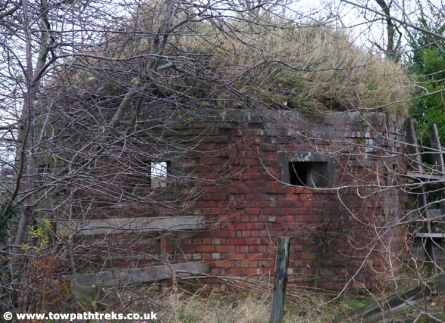
From: www.towpathtreks.co.uk
This brick built/covered pill box is near Halsall Cutting close to Harkers Bridge #23. It is hard to see in summer as there is a tree growing in front of it. It's roof is covered in vegetation too.